
FCCInfo.com
A Service of Cavell, Mertz & Associates, Inc.
(855) FCC-INFO
|
|
|
|
|
||||||||||||||||
|
|
KYFO-FM1 Channel: 238D 95.5 MHz Salt Lake City, Utah Service: FB - A booster station or application for a booster. Facility ID: 171187 Fac. Service: FB Programming Delivery Method: Unspecified Status: License Application Accepted: 05/13/2008 Application Granted: 06/18/2008 File Number: BLFTB-20080513ABV License Expires: 00/00/0000 Prefix Type: This is a license for a booster Application Type: License To Cover FCC Website Links: LMS Facility Details This Application CDBS Application Other KYFO-FM1 Applications Other KYFO-FM1 Applications in CDBS Including Superseded Applications Mailing Address Correspondence for KYFO-FM1 Correspondence related to application BLFTB-20080513ABV Service Contour - Open Street Map or USGS Map (60 dBu) Service Contour - KML / Google Earth (60 dBu) Facility Type: NON-COMMERCIAL EDUC. FM Class: D, A Noncommercial educational operating with no more than 10W Site Location: 40-48-28.8 N 111-53-24.8 W (NAD 83) Site Location: 40-48-29.0 N 111-53-22.0 W (Converted to NAD 27) Effective Radiated Power: 0 kW Horiz. ; 0.007 kW Vert. Transmitter Output Power: 0.008 kW Antenna Center HAAT: 0 m Antenna Center AMSL: 0 m Horiz.; 1843 m Vert. Antenna Center HAG: 0 m Horiz.; 32 m Vert. Site Elevation: 1811 m. (5942 ft.) Height Overall*: 40 m (131 ft.) (* As Filed In This Application, may differ from ASR Data, Below.) Directional Antenna Antenna Make/Model: None Antenna ID: 78927 Polarization:
| ||||||||||||||||||
| Antenna Data for Antenna Id: 78927 KYFO-FM1 FB File: BLFTB-20080513ABV None - Service: FB Pattern and Field Values Include a 255° Clockwise Rotation | 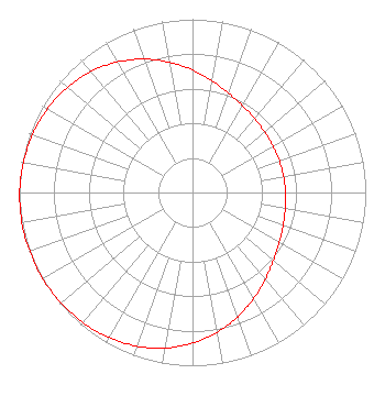 | ||||||||||||||||||
| Azimuth | Ratio | Azimuth | Ratio | Azimuth | Ratio | Azimuth | Ratio | ||||||||||||
| 5 | 0.679 | 15 | 0.630 | 25 | 0.592 | 35 | 0.566 | ||||||||||||
| 45 | 0.549 | 55 | 0.540 | 65 | 0.535 | 75 | 0.534 | ||||||||||||
| 85 | 0.535 | 95 | 0.540 | 105 | 0.549 | 115 | 0.566 | ||||||||||||
| 125 | 0.592 | 135 | 0.630 | 145 | 0.679 | 155 | 0.735 | ||||||||||||
| 165 | 0.792 | 175 | 0.845 | 185 | 0.892 | 195 | 0.929 | ||||||||||||
| 205 | 0.956 | 215 | 0.975 | 225 | 0.987 | 235 | 0.995 | ||||||||||||
| 245 | 0.999 | 255 | 1.000 | 265 | 0.999 | 275 | 0.995 | ||||||||||||
| 285 | 0.987 | 295 | 0.975 | 305 | 0.956 | 315 | 0.929 | ||||||||||||
| 325 | 0.892 | 335 | 0.845 | 345 | 0.792 | 355 | 0.735 | ||||||||||||
Structure Registration Number 1044646 Structure Type: TOWER Registered To: ALPHA COMMUNICATIONS SITES DBA = UTAH COMMUNICATIONS INC Structure Address: E Of Bonneville Dr Between Jones And Hall Canyons Salt Lake City, UT County Name: Salt Lake County ASR Issued: 04/20/1998 Date Built: 01/01/1994 Site Elevation: 1810.8 m (5941 ft.) Structure Height: 37.2 m (122 ft.) Height Overall: 40.2 m (132 ft.) Overall Height AMSL: 1851 m (6073 ft.) FAA Determination: 09/29/1995 FAA Study #: 94-ANM-0377-OE Paint & Light FAA Chapters: NONE Removed expiration date from determination. Scenario 1./jjs/case#635066 40-48-29.0 N 111-53-25.0 W (NAD 83) 40-48-29.2 N 111-53-22.2 W (Converted to NAD 27) |
11530 Carmel Commons Boulevard Charlotte, NC 28226 Phone: 704-523-5555 | Date: 05/13/2008 Application Certifier BIBLE BROADCASTING NETWORK, INC. 11530 Carmel Commons Boulevard Charlotte, NC 28226 Applicant JUSTIN W. ASHER Munn-reese, Inc. Po Box 220, 385 Airport Drive Coldwater, MI 49036-0220 CONSULTING ENGINEER GARY S. SMITHWICK Smithwick & Belendiuk, P.c. 5028 Wisconsin Avenue, Nw Suite 301 Washington, DC 20016 | |||||||||||||||||