
FCCInfo.com
A Service of Cavell, Mertz & Associates, Inc.
(855) FCC-INFO
|
|
|
|
|
||||||||||||||||
|
|
K278AM Channel: 278D 103.5 MHz Spearfish, South Dakota Service: FX - A translator or application for a translator. Facility ID: 67365 Fac. Service: FX Programming Delivery Method: Unspecified Status: License Application Accepted: 01/14/2000 Application Granted: 02/04/2000 File Number: BLFT-19991105AAY License Expires: 00/00/0000 Prefix Type: This is a license for a translator Application Type: License To Cover FCC Website Links: LMS Facility Details This Application CDBS Application Other K278AM Applications Other K278AM Applications in CDBS Including Superseded Applications Mailing Address Correspondence for K278AM Correspondence related to application BLFT-19991105AAY Service Contour - Open Street Map or USGS Map (60 dBu) Service Contour - KML / Google Earth (60 dBu) Class: D, A Noncommercial educational operating with no more than 10W Site Location: 44-29-32.9 N 103-50-06.7 W (NAD 83) Site Location: 44-29-33.0 N 103-50-05.0 W (Converted to NAD 27) Effective Radiated Power: 0.049 kW Horiz. ; 0 kW Vert. Transmitter Output Power: 0.01 kW Antenna Center HAAT: 292 m Horiz.; 0 m Vert. Antenna Center AMSL: 1377 m Horiz.; 0 m Vert. Antenna Center HAG: 12 m Horiz.; 0 m Vert. Calculated Site Elevation: 1365 m. (4478 ft.) Height Overall*: 20 m (66 ft.) (* As Filed In This Application, may differ from ASR Data, Below.) Directional Antenna Antenna Make/Model: None Antenna ID: 15968 Polarization:
| ||||||||||||||||||
| Antenna Data for Antenna Id: 15968 K278AM FX File: BLFT-19991105AAY None - Service: FX | 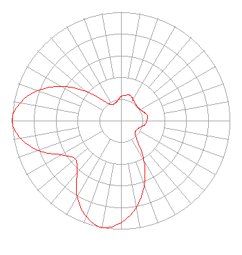 | ||||||||||||||||||
| Azimuth | Ratio | Azimuth | Ratio | Azimuth | Ratio | Azimuth | Ratio | ||||||||||||
| 0 | 0.222 | 10 | 0.237 | 20 | 0.247 | 30 | 0.224 | ||||||||||||
| 40 | 0.204 | 50 | 0.197 | 60 | 0.204 | 70 | 0.224 | ||||||||||||
| 80 | 0.247 | 90 | 0.237 | 100 | 0.222 | 110 | 0.185 | ||||||||||||
| 120 | 0.168 | 130 | 0.171 | 140 | 0.225 | 150 | 0.419 | ||||||||||||
| 160 | 0.628 | 170 | 0.812 | 180 | 0.940 | 190 | 1.000 | ||||||||||||
| 200 | 0.937 | 210 | 0.806 | 220 | 0.631 | 230 | 0.549 | ||||||||||||
| 240 | 0.631 | 250 | 0.806 | 260 | 0.937 | 270 | 1.000 | ||||||||||||
| 280 | 0.940 | 290 | 0.812 | 300 | 0.628 | 310 | 0.419 | ||||||||||||
| 320 | 0.225 | 330 | 0.171 | 340 | 0.168 | 350 | 0.185 | ||||||||||||
Structure Registration Number 1061651 [ASR Heights Differ from K278AM Application] Structure Type: LTOWER Registered To: Riverfront Broadcasting, LLC Structure Address: 1.2 Mi E On Lookout Mountain Spearfish, SD County Name: Lawrence County ASR Issued: 10/03/2019 Date Built: 01/01/1962 Site Elevation: 1364.9 m (4478 ft.) Structure Height: 15.2 m (50 ft.) Height Overall: 16.5 m (54 ft.) Overall Height AMSL: 1381.4 m (4532 ft.) FAA Determination: 05/16/2018 FAA Study #: 2018-AGL-6572-OE Paint & Light FAA Chapters: NONE PRIOR STUDY 2011-AGL-8204-OE 44-29-33.9 N 103-50-06.9 W (NAD 83) 44-29-34.0 N 103-50-05.2 W (Converted to NAD 27) |
407 West 11th Street Yankton, SD 57078 Phone: 605-661-2393 Limited Liability Company | Date: 11/05/1999 Application Certifier DUHAMEL BROADCASTING ENTERPRISES 2001 Pennsylvania Avenue, N.w. Washington, DC 20006 Applicant PRESIDENT | |||||||||||||||||