
FCCInfo.com
A Service of Cavell, Mertz & Associates, Inc.
(855) FCC-INFO
|
|
WFIX from 02/16/1987 WFIX from 04/29/1986 |
|
|
||||||||||||||||
|
|
WFIX Channel: 217C1 91.3 MHz Florence, Alabama Service: FM - A full-service FM station or application. Facility ID: 67799 Fac. Service: FM Status: License Application Accepted: 09/08/2005 Application Granted: 09/27/2005 File Number: BLED-20050908ABG License Expires: 00/00/0000 Prefix Type: This is a license for a noncommercial educational FM station Application Type: License To Cover FCC Website Links: LMS Facility Details This Application CDBS Application Other WFIX Applications Other WFIX Applications in CDBS Including Superseded Applications Mailing Address Correspondence for WFIX Correspondence related to application BLED-20050908ABG Service Contour - Open Street Map or USGS Map (60 dBu) Service Contour - KML / Google Earth (60 dBu) Public Inspection Files Facility Type: NON-COMMERCIAL EDUC. FM Class: C1, A Zone II station; with 50kW-100kW ERP and a class contour distance 52km-72km Site Location: 34-40-24.3 N 87-42-56.1 W (NAD 83) Site Location: 34-40-24.0 N 87-42-56.0 W (Converted to NAD 27) Effective Radiated Power: 100 kW Transmitter Output Power: 16.03 kW Antenna Center HAAT: 265 m (869 ft.) Antenna Center AMSL: 450 m (1476 ft.) Antenna Center HAG: 191 m (627 ft.) Site Elevation: 259 m. (850 ft.) Height Overall*: 250 m (820 ft.) (* As Filed In This Application, may differ from ASR Data, Below.) Directional Antenna Antenna Make/Model: DIA 102117, 8 sections Antenna ID: 69493 Polarization: | ||||||||||||||||||
| Antenna Data for Antenna Id: 69493 WFIX FM File: BLED-20050908ABG DIA - 102117, 8 sections Service: FM | 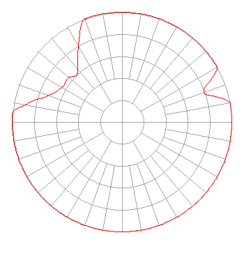 | ||||||||||||||||||
| Azimuth | Ratio | Azimuth | Ratio | Azimuth | Ratio | Azimuth | Ratio | ||||||||||||
| 0 | 1.000 | 10 | 1.000 | 20 | 1.000 | 30 | 1.000 | ||||||||||||
| 40 | 1.000 | 50 | 1.000 | 60 | 1.000 | 70 | 0.794 | ||||||||||||
| 80 | 1.000 | 90 | 1.000 | 100 | 1.000 | 110 | 1.000 | ||||||||||||
| 120 | 1.000 | 130 | 1.000 | 140 | 1.000 | 150 | 1.000 | ||||||||||||
| 160 | 1.000 | 170 | 1.000 | 180 | 1.000 | 190 | 1.000 | ||||||||||||
| 200 | 1.000 | 210 | 1.000 | 220 | 1.000 | 230 | 1.000 | ||||||||||||
| 240 | 1.000 | 250 | 1.000 | 260 | 1.000 | 270 | 1.000 | ||||||||||||
| 275 | 1.000 | 280 | 0.891 | 290 | 0.708 | 300 | 0.631 | ||||||||||||
| 310 | 0.631 | 315 | 0.596 | 320 | 0.631 | 330 | 0.794 | ||||||||||||
| 340 | 1.000 | 350 | 1.000 | ||||||||||||||||
Structure Registration Number 1037310 Structure Type: 2TOWER Registered To: BIG RIVER BROADCASTING Structure Address: 1215 New Cut Rd Tuscumbia, AL County Name: Colbert County ASR Issued: 01/12/1998 Date Built: 01/01/1988 Site Elevation: 259 m (850 ft.) Structure Height: 248.4 m (815 ft.) Height Overall: 250 m (820 ft.) Overall Height AMSL: 509 m (1670 ft.) FAA Determination: 04/04/1986 FAA Study #: 85-ASO-1798-OE FAA Circular #: 70/7460-1G Paint & Light FAA Chapters: 3, 4, 5, 9 34-40-24.0 N 87-42-56.0 W (NAD 83) 34-40-23.7 N 87-42-55.9 W (Converted to NAD 27) |
113 North Seminary Street Florence, AL 35630-1564 Private Not-for-Profit Educational Institution | Date: 09/08/2005 Application Certifier TRI-STATE INSPIRATIONAL BROADCASTING 113 North Seminary Street Florence, AL 35630 Applicant KEVIN C. KIDD Kk Broadcast Engineering 51 Ridge Lane Lawrenceburg, TN 38464 CONSULTING ENGINEER M. SCOTT JOHNSON, ESQUIRE Fletcher, Heald & Hildreth, Plc | |||||||||||||||||
| |||||||||||||||||||