
FCCInfo.com
A Service of Cavell, Mertz & Associates, Inc.
(855) FCC-INFO
|
|
|
|
|
||||||||||||||||
|
|
K220HX Channel: 220D 91.9 MHz Franklin, Nebraska Service: FX - A translator or application for a translator. Facility ID: 93753 Fac. Service: FX Programming Delivery Method: Unspecified Status: License Application Accepted: 06/07/2000 Application Granted: 08/24/2000 File Number: BLFT-20000524ABL License Expires: 00/00/0000 Prefix Type: This is a license for a translator Application Type: License To Cover FCC Website Links: LMS Facility Details This Application CDBS Application Other K220HX Applications Other K220HX Applications in CDBS Including Superseded Applications Mailing Address Correspondence for K220HX Correspondence related to application BLFT-20000524ABL Service Contour - Open Street Map or USGS Map (60 dBu) Service Contour - KML / Google Earth (60 dBu) Class: D, A Noncommercial educational operating with no more than 10W Site Location: 40-12-21.0 N 98-56-43.3 W (NAD 83) Site Location: 40-12-21.0 N 98-56-42.0 W (Converted to NAD 27) Effective Radiated Power: 0 kW Horiz. ; 0.14 kW Vert. Transmitter Output Power: 0.16 kW Antenna Center HAAT: 0 m Horiz.; 106.9 m Vert. Antenna Center AMSL: 0 m Horiz.; 734 m Vert. Antenna Center HAG: 0 m Horiz.; 85 m Vert. Site Elevation: 649 m. (2129 ft.) Height Overall*: 95 m (312 ft.) (* As Filed In This Application, may differ from ASR Data, Below.) Directional Antenna Antenna Make/Model: None Antenna ID: 16017 Polarization:
| ||||||||||||||||||
| Antenna Data for Antenna Id: 16017 K220HX FX File: BLFT-20000524ABL None - Service: FX Pattern and Field Values Include a 155° Clockwise Rotation | 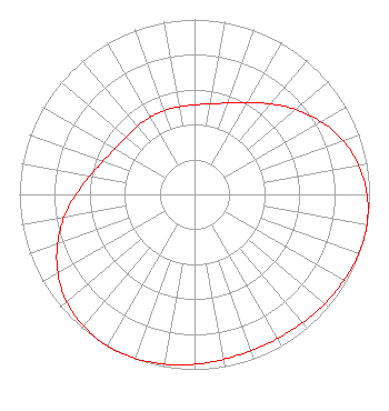 | ||||||||||||||||||
| Azimuth | Ratio | Azimuth | Ratio | Azimuth | Ratio | Azimuth | Ratio | ||||||||||||
| 5 | 0.517 | 15 | 0.538 | 25 | 0.579 | 35 | 0.639 | ||||||||||||
| 45 | 0.715 | 55 | 0.795 | 65 | 0.869 | 75 | 0.930 | ||||||||||||
| 85 | 0.972 | 95 | 0.995 | 105 | 1.000 | 115 | 0.992 | ||||||||||||
| 125 | 0.978 | 135 | 0.964 | 145 | 0.953 | 155 | 0.949 | ||||||||||||
| 165 | 0.953 | 175 | 0.964 | 185 | 0.978 | 195 | 0.992 | ||||||||||||
| 205 | 1.000 | 215 | 0.995 | 225 | 0.972 | 235 | 0.930 | ||||||||||||
| 245 | 0.869 | 255 | 0.795 | 265 | 0.715 | 275 | 0.639 | ||||||||||||
| 285 | 0.579 | 295 | 0.538 | 305 | 0.517 | 315 | 0.509 | ||||||||||||
| 325 | 0.509 | 335 | 0.509 | 345 | 0.509 | 355 | 0.509 | ||||||||||||
Structure Registration Number 1064353 [ASR Heights Differ from K220HX Application] Structure Type: GTOWER Registered To: SBA Steel LLC Structure Address: 1326 "o" Road (ne20061-a) Franklin, NE County Name: Franklin County ASR Issued: 03/18/2016 Date Built: 01/01/1992 Site Elevation: 652.2 m (2140 ft.) Structure Height: 93.9 m (308 ft.) Height Overall: 95.1 m (312 ft.) Overall Height AMSL: 747.3 m (2452 ft.) FAA Determination: 03/17/2016 FAA Study #: 2016-ACE-822-OE FAA Circular #: 70/7460-1L Paint & Light FAA Chapters: 4, 8, 12 40-12-21.2 N 98-56-43.5 W (NAD 83) 40-12-21.2 N 98-56-42.2 W (Converted to NAD 27) |
P.o. Box 391 4002 N. 3300 E. Twin Falls, ID 83303 Phone: 208-733-3133 | Date: 05/24/2000 Application Certifier CALVARY CHAPEL OF TWIN FALLS, INC. 4002 N. 3300 E. Twin Falls, ID 83301 Applicant | |||||||||||||||||