
FCCInfo.com
A Service of Cavell, Mertz & Associates, Inc.
(855) FCC-INFO
|
|
|
|
|
||||||||||||||||
|
|
W253BK Channel: 253D 98.5 MHz Winchester, Kentucky Service: FX - A translator or application for a translator. Facility ID: 148885 Fac. Service: FX Programming Delivery Method: Unspecified Status: License Application Accepted: 10/31/2014 Application Granted: 11/24/2014 File Number: BLFT-20141031AAB License Expires: 00/00/0000 Prefix Type: This is a license for a translator Application Type: License To Cover FCC Website Links: LMS Facility Details This Application CDBS Application Other W253BK Applications Other W253BK Applications in CDBS Including Superseded Applications Mailing Address Correspondence for W253BK Correspondence related to application BLFT-20141031AAB Service Contour - Open Street Map or USGS Map (60 dBu) Service Contour - KML / Google Earth (60 dBu) Class: D, A Noncommercial educational operating with no more than 10W Site Location: 38-02-06.3 N 84-27-01.8 W (NAD 83) Site Location: 38-02-06.0 N 84-27-02.0 W (Converted to NAD 27) Effective Radiated Power: 0 kW Horiz. ; 0.25 kW Vert. Transmitter Output Power: 0.282 kW Antenna Center HAAT: 0 m Antenna Center AMSL: 0 m Horiz.; 439 m Vert. Antenna Center HAG: 0 m Horiz.; 113 m Vert. Site Elevation: 326 m. (1070 ft.) Height Overall*: 162 m (531 ft.) (* As Filed In This Application, may differ from ASR Data, Below.) Directional Antenna Antenna Make/Model: None Antenna ID: 31326 Polarization:
| ||||||||||||||||||
| Antenna Data for Antenna Id: 31326 W253BK FX File: BLFT-20141031AAB None - Service: FX Pattern and Field Values Include a 224° Clockwise Rotation | 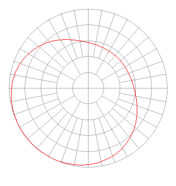 | ||||||||||||||||||
| Azimuth | Ratio | Azimuth | Ratio | Azimuth | Ratio | Azimuth | Ratio | ||||||||||||
| 4 | 0.566 | 14 | 0.549 | 24 | 0.540 | 34 | 0.535 | ||||||||||||
| 44 | 0.534 | 54 | 0.535 | 64 | 0.540 | 74 | 0.549 | ||||||||||||
| 84 | 0.566 | 94 | 0.592 | 104 | 0.630 | 114 | 0.679 | ||||||||||||
| 124 | 0.735 | 134 | 0.792 | 144 | 0.845 | 154 | 0.892 | ||||||||||||
| 164 | 0.929 | 174 | 0.956 | 184 | 0.975 | 194 | 0.987 | ||||||||||||
| 204 | 0.995 | 214 | 0.999 | 224 | 1.000 | 234 | 0.999 | ||||||||||||
| 244 | 0.995 | 254 | 0.987 | 264 | 0.975 | 274 | 0.956 | ||||||||||||
| 284 | 0.929 | 294 | 0.892 | 304 | 0.845 | 314 | 0.792 | ||||||||||||
| 324 | 0.735 | 334 | 0.679 | 344 | 0.630 | 354 | 0.592 | ||||||||||||
Structure Registration Number 1036781 Structure Type: TOWER Registered To: Vertical Bridge CC FM, LLC Structure Address: 1087 New Circle Road Lexington, KY County Name: Fayette County ASR Issued: 11/08/2018 Date Built: 04/18/1997 Site Elevation: 326.1 m (1070 ft.) Structure Height: 156.1 m (512 ft.) Height Overall: 162.4 m (533 ft.) Overall Height AMSL: 488.5 m (1603 ft.) FAA Determination: 11/26/1997 FAA Study #: 97-ASO-5146-OE FAA Circular #: 70/7460-1J Paint & Light FAA Chapters: 3, 4, 5, 13 38-02-06.0 N 84-27-02.0 W (NAD 83) 38-02-05.7 N 84-27-02.2 W (Converted to NAD 27) |
4111 Plains Blvd. Amarillo, TX 79106 Phone: 208-733-3551 | Date: 10/31/2014 Application Certifier EDGEWATER BROADCASTING, INC. 160 Gooding St. West Suite B Twin Falls, ID 83301 Applicant GENE WISNIEWSKI 160 Gooding Street West Suite A Twin Falls, ID 83301 CONSULTING ENGINEER CLARK PARRISH Edgewater Broadcasting, Inc. 160 Gooding St. West Suite B Twin Falls, ID 83301 | |||||||||||||||||