
FCCInfo.com
A Service of Cavell, Mertz & Associates, Inc.
(855) FCC-INFO
|
|
K276FI from 07/26/2004 |
|
|
||||||||||||||||
|
|
K276FI Channel: 276D 103.1 MHz Fremont, Nebraska Service: FX - A translator or application for a translator. Facility ID: 140372 Fac. Service: FX Programming Delivery Method: Unspecified Status: License Application Accepted: 07/19/2010 Application Granted: 07/30/2010 File Number: BLFT-20100719ADG License Expires: 00/00/0000 Prefix Type: This is a license for a translator Application Type: License To Cover FCC Website Links: LMS Facility Details This Application CDBS Application Other K276FI Applications Other K276FI Applications in CDBS Including Superseded Applications Mailing Address Correspondence for K276FI Correspondence related to application BLFT-20100719ADG Service Contour - Open Street Map or USGS Map (60 dBu) Service Contour - KML / Google Earth (60 dBu) Class: D, A Noncommercial educational operating with no more than 10W Site Location: 41-24-40.0 N 96-31-58.1 W (NAD 83) Site Location: 41-24-40.0 N 96-31-57.0 W (Converted to NAD 27) Effective Radiated Power: 0.25 kW Transmitter Output Power: 0.094 kW Antenna Center HAAT: 86.1 m Horiz.; 0 m Vert. Antenna Center AMSL: 464 m (1522 ft.) Antenna Center HAG: 52 m (171 ft.) Site Elevation: 412 m. (1352 ft.) Height Overall*: 112 m (367 ft.) (* As Filed In This Application, may differ from ASR Data, Below.) Directional Antenna Antenna Make/Model: None Antenna ID: 98466 Polarization:
| ||||||||||||||||||
| Antenna Data for Antenna Id: 98466 K276FI FX File: BLFT-20100719ADG None - Service: FX Pattern and Field Values Include a 60° Clockwise Rotation | 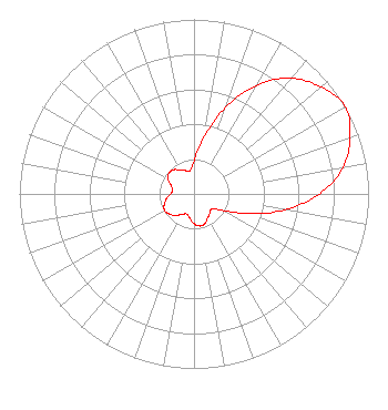 | ||||||||||||||||||
| Azimuth | Ratio | Azimuth | Ratio | Azimuth | Ratio | Azimuth | Ratio | ||||||||||||
| 0 | 0.190 | 10 | 0.329 | 20 | 0.528 | 30 | 0.718 | ||||||||||||
| 40 | 0.866 | 50 | 0.952 | 60 | 1.000 | 70 | 0.952 | ||||||||||||
| 80 | 0.866 | 90 | 0.718 | 100 | 0.528 | 110 | 0.329 | ||||||||||||
| 120 | 0.190 | 130 | 0.134 | 140 | 0.142 | 150 | 0.157 | ||||||||||||
| 160 | 0.181 | 170 | 0.187 | 180 | 0.171 | 190 | 0.140 | ||||||||||||
| 200 | 0.123 | 210 | 0.135 | 220 | 0.160 | 230 | 0.182 | ||||||||||||
| 240 | 0.193 | 250 | 0.182 | 260 | 0.160 | 270 | 0.135 | ||||||||||||
| 280 | 0.123 | 290 | 0.140 | 300 | 0.171 | 310 | 0.187 | ||||||||||||
| 320 | 0.181 | 330 | 0.157 | 340 | 0.142 | 350 | 0.134 | ||||||||||||
Structure Registration Number 1025599 [ASR Heights Differ from K276FI Application] Structure Type: TOWER Registered To: SNYDER, KENNETH C DBA = METRO PAGING RADIO COMMUNICATIONS CO Structure Address: 1.5 Mi S On Hwy 77 1.8 Mi W On Cty Rd From Fremont, NE County Name: Saunders County ASR Issued: 07/17/1997 Date Built: 10/01/1978 Site Elevation: 411.5 m (1350 ft.) Structure Height: 106.7 m (350 ft.) Height Overall: 111.8 m (367 ft.) Overall Height AMSL: 523.3 m (1717 ft.) FAA Determination: 06/25/1996 FAA Study #: 96-ACE-0384-OE FAA Circular #: 70/7460-1J Paint & Light FAA Chapters: 3, 4, 5, 13 41-24-40.0 N 96-31-58.0 W (NAD 83) 41-24-40.0 N 96-31-56.9 W (Converted to NAD 27) |
10550 Barkley, Suite 108 Overland Park, KS 66212 Phone: 913-642-7770 | Date: 07/19/2010 Application Certifier COMMUNITY BROADCASTING, INC. 10550 Barkley, Suite 108 Overland Park, KS 66212 Applicant JEREMY D. RUCK, PE D.l. Markley & Associates, Inc. 2104 West Moss Avenue Peoria, IL 61604 CONSULTING ENGINEER HARRY C. MARTIN Fletcher, Heald & Hildreth, Plc 1300 North 17th Street 11th Floor Arlington, VA 22209 | |||||||||||||||||