
FCCInfo.com
A Service of Cavell, Mertz & Associates, Inc.
(855) FCC-INFO
|
|
W251CJ from 10/29/2008 W251CJ from 04/24/1984 |
|
|
||||||||||||||||
|
|
W251CJ Channel: 251D 98.1 MHz Bristol, Tennessee Service: FX - A translator or application for a translator. Facility ID: 27506 Fac. Service: FX Programming Delivery Method: Unspecified Status: License Application Accepted: 07/29/2019 Application Granted: 08/05/2019 File Number: BLFT-20190729ABK License Expires: 00/00/0000 Prefix Type: This is a license for a translator Application Type: License To Cover FCC Website Links: LMS Facility Details This Application CDBS Application Other W251CJ Applications Other W251CJ Applications in CDBS Including Superseded Applications Mailing Address Correspondence for W251CJ Correspondence related to application BLFT-20190729ABK Service Contour - Open Street Map or USGS Map (60 dBu) Service Contour - KML / Google Earth (60 dBu) Class: D, A Noncommercial educational operating with no more than 10W Site Location: 36-25-53.4 N 82-08-15.5 W (NAD 83) Site Location: 36-25-53.0 N 82-08-16.0 W (Converted to NAD 27) Effective Radiated Power: 0.25 kW Transmitter Output Power: 0.32 kW Antenna Center HAAT: 0 m Antenna Center AMSL: 1298 m (4259 ft.) Antenna Center HAG: 26 m (85 ft.) Site Elevation: 1272 m. (4173 ft.) Height Overall*: 69 m (226 ft.) (* As Filed In This Application, may differ from ASR Data, Below.) Directional Antenna Antenna Make/Model: None Antenna ID: 135077 Polarization:
| ||||||||||||||||||
| Antenna Data for Antenna Id: 135077 W251CJ FX File: BLFT-20190729ABK None - Service: FX | 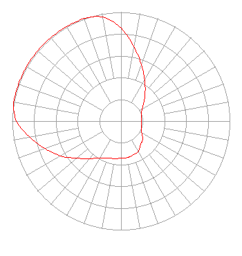 | ||||||||||||||||||
| Azimuth | Ratio | Azimuth | Ratio | Azimuth | Ratio | Azimuth | Ratio | ||||||||||||
| 0 | 0.852 | 10 | 0.690 | 20 | 0.548 | 30 | 0.435 | ||||||||||||
| 40 | 0.345 | 50 | 0.275 | 60 | 0.225 | 70 | 0.197 | ||||||||||||
| 80 | 0.192 | 90 | 0.190 | 100 | 0.190 | 110 | 0.200 | ||||||||||||
| 120 | 0.220 | 130 | 0.260 | 140 | 0.280 | 150 | 0.320 | ||||||||||||
| 160 | 0.330 | 170 | 0.340 | 180 | 0.340 | 190 | 0.350 | ||||||||||||
| 200 | 0.360 | 210 | 0.390 | 220 | 0.450 | 230 | 0.530 | ||||||||||||
| 240 | 0.640 | 250 | 0.740 | 260 | 0.850 | 270 | 0.960 | ||||||||||||
| 280 | 1.000 | 290 | 1.000 | 300 | 1.000 | 310 | 1.000 | ||||||||||||
| 320 | 1.000 | 330 | 1.000 | 340 | 1.000 | 350 | 0.969 | ||||||||||||
Structure Registration Number 1054538 Structure Type: TOWER Registered To: HOLSTON VALLEY BROADCASTING CORPORATION Structure Address: 6247 Panhandle Road Hunter, TN County Name: Carter County ASR Issued: 08/06/1998 Date Built: 10/01/1994 Site Elevation: 1271.9 m (4173 ft.) Structure Height: 51.6 m (169 ft.) Height Overall: 68.8 m (226 ft.) Overall Height AMSL: 1340.7 m (4399 ft.) FAA Determination: 07/14/1998 FAA Study #: 98-ASO-2328-OE FAA Circular #: 70/7460-1J Paint & Light FAA Chapters: 3, 4, 5, 13 36-25-53.0 N 82-08-15.0 W (NAD 83) 36-25-52.6 N 82-08-15.5 W (Converted to NAD 27) |
222 Commerce St Kingsport, TN 37660-1971 Phone: 423-246-9578 | Date: 07/29/2019 Application Certifier HOLSTON VALLEY BROADCASTING CORPORATION 222 Commerce Street Kingsport, TN 37660 Applicant CHARLES M. ANDERSON 1519 Euclid Avenue Bowling Green, KY 42103 ENGINEERING CONSULTANT DENNIS J. KELLY Law Office Of Dennis J. Kelly Post Office Box 41177 Washington, DC 20018-0577 | |||||||||||||||||