
FCCInfo.com
A Service of Cavell, Mertz & Associates, Inc.
(855) FCC-INFO
|
|
|
|
|
||||||||||||||||
|
|
WSMA Channel: 213B1 90.5 MHz Scituate, Massachusetts Service: FM - A full-service FM station or application. Facility ID: 122202 Fac. Service: FM Status: License Application Accepted: 05/16/2008 Application Granted: 11/03/2009 File Number: BMLED-20080516AAL License Expires: 00/00/0000 Prefix Type: This is a modification of license for a noncommercial educational FM station Application Type: Minor Modification FCC Website Links: LMS Facility Details This Application CDBS Application Other WSMA Applications Other WSMA Applications in CDBS Including Superseded Applications Mailing Address Correspondence for WSMA Correspondence related to application BMLED-20080516AAL Service Contour - Open Street Map or USGS Map (60 dBu) Service Contour - KML / Google Earth (60 dBu) Public Inspection Files Facility Type: NON-COMMERCIAL EDUC. FM Class: B1, A Zone I or I-A station; with 6kW-25kW ERP and a class contour distance 28km-39km Site Location: 41-56-02.4 N 70-35-08.1 W (NAD 83) Site Location: 41-56-02.0 N 70-35-10.0 W (Converted to NAD 27) Effective Radiated Power: 0.005 kW Horiz. ; 7.7 kW Vert. Transmitter Output Power: 2.329 kW Antenna Center HAAT: 150 m (492 ft.) Antenna Center AMSL: 164 m (538 ft.) Antenna Center HAG: 81 m (266 ft.) Site Elevation: 83 m. (272 ft.) Height Overall*: 128 m (420 ft.) (* As Filed In This Application, may differ from ASR Data, Below.) Directional Antenna Antenna Make/Model: Propagation System Inc FMPV-2C-DA, Two Sections, full wavelength spaced Antenna ID: 71671 Polarization:
| ||||||||||||||||||
| Antenna Data for Antenna Id: 71671 WSMA FM File: BMLED-20080516AAL Propagation System Inc - FMPV-2C-DA, Two Sections, full wavelength spaced Service: FM | 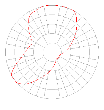 | ||||||||||||||||||
| Azimuth | Ratio | Azimuth | Ratio | Azimuth | Ratio | Azimuth | Ratio | ||||||||||||
| 0 | 1.000 | 10 | 1.000 | 20 | 1.000 | 30 | 0.980 | ||||||||||||
| 40 | 0.820 | 50 | 0.670 | 60 | 0.532 | 70 | 0.423 | ||||||||||||
| 80 | 0.336 | 90 | 0.267 | 100 | 0.214 | 110 | 0.180 | ||||||||||||
| 120 | 0.179 | 130 | 0.179 | 140 | 0.178 | 150 | 0.178 | ||||||||||||
| 160 | 0.224 | 170 | 0.282 | 180 | 0.355 | 190 | 0.447 | ||||||||||||
| 200 | 0.562 | 210 | 0.708 | 220 | 0.891 | 230 | 1.000 | ||||||||||||
| 240 | 1.000 | 250 | 0.831 | 260 | 0.660 | 270 | 0.570 | ||||||||||||
| 280 | 0.520 | 290 | 0.466 | 300 | 0.500 | 310 | 0.629 | ||||||||||||
| 320 | 0.792 | 330 | 0.920 | 340 | 0.954 | 350 | 1.000 | ||||||||||||
Structure Registration Number 1007828 Structure Type: GTOWER Registered To: Industrial Tower and Wireless, LLC Structure Address: 265 State Road Plymouth, MA County Name: Plymouth County ASR Issued: 03/28/2023 Date Built: 02/16/1998 Site Elevation: 82.9 m (272 ft.) Structure Height: 120.3 m (395 ft.) Height Overall: 128 m (420 ft.) Overall Height AMSL: 210.9 m (692 ft.) FAA Determination: 03/27/2023 FAA Study #: 2022-ANE-2880-OE FAA Circular #: 70/7460-1L Paint & Light FAA Chapters: 4, 8, 12 OM&L to remain the same as prior study = A MED-DUAL SYSTEM 41-56-01.8 N 70-35-08.2 W (NAD 83) 41-56-01.4 N 70-35-10.1 W (Converted to NAD 27) |
4002 N. 3300 E. Twin Falls, ID 83303 Phone: 208-733-3133 Not-for-Profit | Date: 05/16/2008 Application Certifier CALVARY CHAPEL OF TWIN FALLS, INC. Po Box 391 Twin Falls, ID 83303 Applicant LOIS MILLS Po Box 391 Twin Falls, ID 83303 APPLICATION TECHNICIAN LOIS MILLS Calvary Chapel Of Twin Falls, Inc. | |||||||||||||||||