
FCCInfo.com
A Service of Cavell, Mertz & Associates, Inc.
(855) FCC-INFO
|
|
|
|
|
||||||||||||||||
|
|
W266CM Channel: 266D 101.1 MHz Mobile, Alabama Service: FX - A translator or application for a translator. Facility ID: 150912 Fac. Service: FX Programming Delivery Method: Unspecified Status: License Application Accepted: 05/02/2018 Application Granted: 05/07/2018 File Number: BMLFT-20180502AAB License Expires: 00/00/0000 Prefix Type: This is a modification of license for a translator Application Type: Minor Modification FCC Website Links: LMS Facility Details This Application CDBS Application Other W266CM Applications Other W266CM Applications in CDBS Including Superseded Applications Mailing Address Correspondence for W266CM Correspondence related to application BMLFT-20180502AAB Service Contour - Open Street Map or USGS Map (60 dBu) Service Contour - KML / Google Earth (60 dBu) Class: D, A Noncommercial educational operating with no more than 10W Site Location: 30-43-34.7 N 88-09-06.0 W (NAD 83) Site Location: 30-43-34.0 N 88-09-06.0 W (Converted to NAD 27) Effective Radiated Power: 0.25 kW Transmitter Output Power: 0.393 kW Antenna Center HAAT: 0 m Antenna Center AMSL: 133 m (436 ft.) Antenna Center HAG: 81 m (266 ft.) Site Elevation: 52 m. (171 ft.) Height Overall*: 129 m (423 ft.) (* As Filed In This Application, may differ from ASR Data, Below.) Directional Antenna Antenna Make/Model: None Antenna ID: 124168 Polarization:
| ||||||||||||||||||
| Antenna Data for Antenna Id: 124168 W266CM FX File: BMLFT-20180502AAB None - Service: FX Pattern and Field Values Include a 5° Clockwise Rotation | 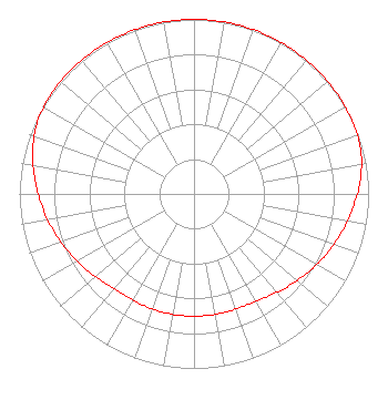 | ||||||||||||||||||
| Azimuth | Ratio | Azimuth | Ratio | Azimuth | Ratio | Azimuth | Ratio | ||||||||||||
| 5 | 1.000 | 15 | 1.000 | 25 | 1.000 | 35 | 1.000 | ||||||||||||
| 45 | 1.000 | 55 | 1.000 | 65 | 0.998 | 75 | 0.988 | ||||||||||||
| 85 | 0.957 | 95 | 0.913 | 105 | 0.872 | 115 | 0.832 | ||||||||||||
| 125 | 0.791 | 135 | 0.755 | 145 | 0.721 | 155 | 0.705 | ||||||||||||
| 165 | 0.701 | 175 | 0.701 | 185 | 0.701 | 195 | 0.701 | ||||||||||||
| 205 | 0.701 | 215 | 0.705 | 225 | 0.721 | 235 | 0.755 | ||||||||||||
| 245 | 0.791 | 255 | 0.832 | 265 | 0.872 | 275 | 0.913 | ||||||||||||
| 285 | 0.957 | 295 | 0.988 | 305 | 0.998 | 315 | 1.000 | ||||||||||||
| 325 | 1.000 | 335 | 1.000 | 345 | 1.000 | 355 | 1.000 | ||||||||||||
Structure Registration Number 1037341 Structure Type: TOWER Registered To: Clearview Tower Company II, LLC Structure Address: End Of Le Ruth Dr 4 Mi N Of Moffat Rd Mobile, AL County Name: Mobile County ASR Issued: 10/16/2014 Date Built: 08/01/1972 Site Elevation: 51.8 m (170 ft.) Structure Height: 128.9 m (423 ft.) Height Overall: 128.9 m (423 ft.) Overall Height AMSL: 180.7 m (593 ft.) Paint & Light FAA Chapters: 1, 3, 12, 21 30-43-35.0 N 88-09-06.0 W (NAD 83) 30-43-34.3 N 88-09-06.0 W (Converted to NAD 27) |
4111 Plains Blvd. Amarillo, TX 79106 Phone: 208-733-3551 Not-for-Profit | Date: 05/02/2018 Application Certifier EDGEWATER BROADCASTING, INC. 160 Gooding Street West Suite B Twin Falls, ID 83301 Applicant GENE WISNIEWSKI 160 Gooding Street West Suite A Twin Falls, ID 83301 CONSULTING ENGINEER CLARK PARRISH Edgewater Broadcasting Inc. 160 Gooding Street West Suite B Twin Falls, ID 83301 | |||||||||||||||||