
FCCInfo.com
A Service of Cavell, Mertz & Associates, Inc.
(855) FCC-INFO
|
|
K279AJ from 06/23/1995 K279AJ from 01/19/1995 K279AJ from 11/05/1986 |
|
|
||||||||||||||||
|
|
K279AJ Channel: 279D 103.7 MHz Roseburg, Oregon Service: FX - A translator or application for a translator. Facility ID: 13709 Fac. Service: FX Programming Delivery Method: Unspecified Status: License Application Accepted: 08/23/2005 Application Granted: 10/18/2005 File Number: BLFT-20050823ABS License Expires: 00/00/0000 Prefix Type: This is a license for a translator Application Type: License To Cover FCC Website Links: LMS Facility Details This Application CDBS Application Other K279AJ Applications Other K279AJ Applications in CDBS Including Superseded Applications Mailing Address Correspondence for K279AJ Correspondence related to application BLFT-20050823ABS Service Contour - Open Street Map or USGS Map (60 dBu) Service Contour - KML / Google Earth (60 dBu) Class: D, A Noncommercial educational operating with no more than 10W Site Location: 43-12-07.4 N 123-22-58.3 W (NAD 83) Site Location: 43-12-08.0 N 123-22-54.0 W (Converted to NAD 27) Effective Radiated Power: 0 kW Horiz. ; 0.075 kW Vert. Transmitter Output Power: 0.48 kW Antenna Center HAAT: 0 m Horiz.; 153 m Vert. Antenna Center AMSL: 0 m Horiz.; 426 m Vert. Antenna Center HAG: 0 m Horiz.; 18 m Vert. Site Elevation: 408 m. (1339 ft.) Height Overall*: 31 m (102 ft.) (* As Filed In This Application, may differ from ASR Data, Below.) Directional Antenna Antenna Make/Model: None Antenna ID: 43897 Polarization:
| ||||||||||||||||||
| Antenna Data for Antenna Id: 43897 K279AJ FX File: BLFT-20050823ABS None - Service: FX | 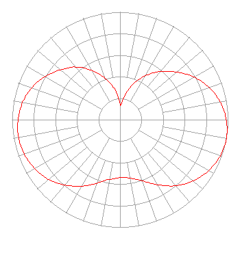 | ||||||||||||||||||
| Azimuth | Ratio | Azimuth | Ratio | Azimuth | Ratio | Azimuth | Ratio | ||||||||||||
| 0 | 0.147 | 3 | 0.137 | 10 | 0.210 | 13 | 0.257 | ||||||||||||
| 20 | 0.350 | 30 | 0.471 | 40 | 0.583 | 50 | 0.687 | ||||||||||||
| 60 | 0.791 | 70 | 0.878 | 80 | 0.942 | 90 | 0.983 | ||||||||||||
| 100 | 1.000 | 110 | 0.987 | 120 | 0.947 | 130 | 0.885 | ||||||||||||
| 140 | 0.801 | 150 | 0.698 | 160 | 0.604 | 170 | 0.551 | ||||||||||||
| 180 | 0.538 | 190 | 0.562 | 192 | 0.571 | 200 | 0.629 | ||||||||||||
| 210 | 0.713 | 220 | 0.792 | 230 | 0.863 | 240 | 0.912 | ||||||||||||
| 250 | 0.942 | 260 | 0.954 | 270 | 0.944 | 280 | 0.916 | ||||||||||||
| 290 | 0.869 | 300 | 0.800 | 310 | 0.721 | 316 | 0.672 | ||||||||||||
| 320 | 0.634 | 330 | 0.529 | 340 | 0.411 | 350 | 0.285 | ||||||||||||
Structure Registration Number 1019017 [ASR Heights Differ from K279AJ Application] Structure Type: TOWER Registered To: JATCOM COMMUNICATIONS INC Structure Address: Nebo Ridge 2.8 Km Sw Center Of Roseburg Or Roseburg Green, OR County Name: Douglas County ASR Issued: 02/23/2009 Date Built: 01/01/1991 Site Elevation: 406.9 m (1335 ft.) Structure Height: 30.5 m (100 ft.) Height Overall: 36 m (118 ft.) Overall Height AMSL: 442.9 m (1453 ft.) FAA Determination: 02/20/2009 FAA Study #: 2009-ANM-170-OE Paint & Light FAA Chapters: NONE PRIOR STUDY 1996-ANM-1007-OE 43-12-07.4 N 123-22-58.3 W (NAD 83) 43-12-08.0 N 123-22-54.0 W (Converted to NAD 27) |
1303 Jewel Drive Roseburg, OR 97471 Phone: 541-672-5761 | Date: 08/23/2005 Application Certifier RAIDER COMMUNICATIONS, INC. 1638 Nw Garden Valley Blvd Roseburg, OR 97470 Applicant J. DOMINIC MONAHAN Luvaas Cobb Suite 300 777 High Street Eugene, OR 97401-2787 LAWRENCE E. MORTON, P.E. 185 Tenango Road Claremont, CA 91711-2341 CONSULTING ENGINEER | |||||||||||||||||