
FCCInfo.com
A Service of Cavell, Mertz & Associates, Inc.
(855) FCC-INFO
|
|
WXBW-FM1 from 12/01/1998 |
|
|
||||||||||||||||
|
|
WXBW-FM1 Channel: 268D 101.5 MHz Huntington, West Virginia Service: FB - A booster station or application for a booster. Facility ID: 70693 Fac. Service: FB Programming Delivery Method: Unspecified Status: License Application Accepted: 11/16/2006 Application Granted: 01/10/2007 File Number: BLFTB-20061116ADN License Expires: 00/00/0000 Prefix Type: This is a license for a booster Application Type: License To Cover FCC Website Links: LMS Facility Details This Application CDBS Application Other WXBW-FM1 Applications Other WXBW-FM1 Applications in CDBS Including Superseded Applications Mailing Address Correspondence for WXBW-FM1 Correspondence related to application BLFTB-20061116ADN Service Contour - Open Street Map or USGS Map (60 dBu) Service Contour - KML / Google Earth (60 dBu) Facility Type: FM STATION Class: D, A Noncommercial educational operating with no more than 10W Site Location: 38-24-25.3 N 82-33-39.6 W (NAD 83) Site Location: 38-24-25.0 N 82-33-40.0 W (Converted to NAD 27) Effective Radiated Power: 0 kW Horiz. ; 3.5 kW Vert. Transmitter Output Power: 0.7 kW Antenna Center HAAT: 0 m Antenna Center AMSL: 0 m Horiz.; 278 m Vert. Antenna Center HAG: 0 m Horiz.; 34 m Vert. Site Elevation: 244 m. (801 ft.) Height Overall*: 55 m (180 ft.) (* As Filed In This Application, may differ from ASR Data, Below.) Directional Antenna Antenna Make/Model: None Antenna ID: 76536 Polarization:
| ||||||||||||||||||
| Antenna Data for Antenna Id: 76536 WXBW-FM1 FB File: BLFTB-20061116ADN None - Service: FB | 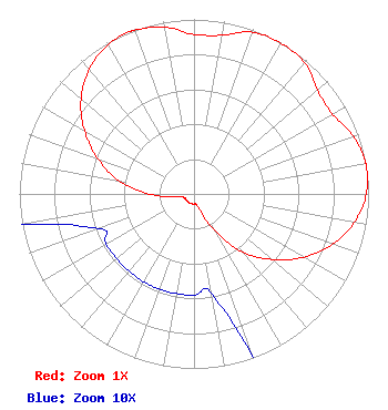 | ||||||||||||||||||
| Azimuth | Ratio | Azimuth | Ratio | Azimuth | Ratio | Azimuth | Ratio | ||||||||||||
| 0 | 0.914 | 10 | 0.923 | 20 | 0.985 | 30 | 0.996 | ||||||||||||
| 40 | 0.985 | 50 | 0.923 | 60 | 0.914 | 70 | 0.970 | ||||||||||||
| 80 | 0.998 | 81 | 1.000 | 90 | 0.986 | 100 | 0.933 | ||||||||||||
| 110 | 0.844 | 120 | 0.724 | 130 | 0.585 | 140 | 0.438 | ||||||||||||
| 150 | 0.256 | 160 | 0.101 | 170 | 0.058 | 180 | 0.058 | ||||||||||||
| 190 | 0.058 | 200 | 0.058 | 210 | 0.058 | 220 | 0.058 | ||||||||||||
| 230 | 0.058 | 240 | 0.058 | 250 | 0.058 | 260 | 0.101 | ||||||||||||
| 270 | 0.256 | 280 | 0.438 | 290 | 0.585 | 300 | 0.724 | ||||||||||||
| 310 | 0.844 | 320 | 0.933 | 330 | 0.986 | 338 | 1.000 | ||||||||||||
| 340 | 0.998 | 350 | 0.970 | ||||||||||||||||
Structure Registration Number 1043534 Structure Type: TOWER Registered To: Kindred Communications, Inc. Structure Address: 0.6 Mi E Of The N & W Railroad Crossing South Point, OH County Name: Lawrence County ASR Issued: 02/08/2024 Date Built: 07/01/1995 Site Elevation: 244 m (801 ft.) Structure Height: 55 m (180 ft.) Height Overall: 55 m (180 ft.) Overall Height AMSL: 299 m (981 ft.) FAA Determination: 06/03/1994 FAA Study #: 94-AGL-2509-OE Paint & Light FAA Chapters: NONE 38-24-25.0 N 82-33-40.0 W (NAD 83) 38-24-24.7 N 82-33-40.4 W (Converted to NAD 27) |
555 Fifth Avenue Suite K Huntington, WV 25701 Phone: 304-523-8401 Corporation | Date: 11/16/2006 Application Certifier CONNOISSEUR MEDIA OF WV-OH, LLC 136 Main Street Suite 202 Westport, CT 06880 Applicant LOUIS ROBERT DUTREIL JR Dutreil Lundin & Rackley Inc 201 Fletcher Ave Sarasota, FL 34237-6019 CONSULTING ENGINEER DAVID D. OXENFORD Davis Wright Tremaine Llp 1500 K Street, Nw Suite 450 Washington, DC 20005 | |||||||||||||||||