
FCCInfo.com
A Service of Cavell, Mertz & Associates, Inc.
(855) FCC-INFO
|
|
|
|
|
||||||||||||||||
|
|
K242AD Channel: 242D 96.3 MHz Ukiah, California Service: FX - A translator or application for a translator. Facility ID: 68733 Fac. Service: FX Programming Delivery Method: Unspecified Status: License Application Accepted: 03/04/2014 Application Granted: 04/16/2014 File Number: BLFT-20140304ACB License Expires: 00/00/0000 Prefix Type: This is a license for a translator Application Type: License To Cover FCC Website Links: LMS Facility Details This Application CDBS Application Other K242AD Applications Other K242AD Applications in CDBS Including Superseded Applications Mailing Address Correspondence for K242AD Correspondence related to application BLFT-20140304ACB Service Contour - Open Street Map or USGS Map (60 dBu) Service Contour - KML / Google Earth (60 dBu) Class: D, A Noncommercial educational operating with no more than 10W Site Location: 39-06-59.6 N 123-13-57.0 W (NAD 83) Site Location: 39-06-60.0 N 123-13-53.0 W (Converted to NAD 27) Effective Radiated Power: 0 kW Horiz. ; 0.25 kW Vert. Transmitter Output Power: 0.075 kW Antenna Center HAAT: 301.6 m Horiz.; 0 m Vert. Antenna Center AMSL: 0 m Horiz.; 768 m Vert. Antenna Center HAG: 0 m Horiz.; 12 m Vert. Site Elevation: 756 m. (2480 ft.) Height Overall*: 21 m (69 ft.) (* As Filed In This Application, may differ from ASR Data, Below.) Directional Antenna Antenna Make/Model: None Antenna ID: 115608 Polarization:
| ||||||||||||||||||
| Antenna Data for Antenna Id: 115608 K242AD FX File: BLFT-20140304ACB None - Service: FX Pattern and Field Values Include a 43° Clockwise Rotation | 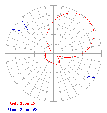 | ||||||||||||||||||
| Azimuth | Ratio | Azimuth | Ratio | Azimuth | Ratio | Azimuth | Ratio | ||||||||||||
| 3 | 0.705 | 13 | 0.821 | 23 | 0.911 | 33 | 0.972 | ||||||||||||
| 43 | 1.000 | 53 | 0.989 | 63 | 0.939 | 73 | 0.851 | ||||||||||||
| 83 | 0.719 | 93 | 0.557 | 103 | 0.371 | 113 | 0.197 | ||||||||||||
| 123 | 0.088 | 133 | 0.139 | 143 | 0.207 | 153 | 0.241 | ||||||||||||
| 163 | 0.240 | 173 | 0.220 | 183 | 0.200 | 193 | 0.189 | ||||||||||||
| 203 | 0.186 | 213 | 0.188 | 223 | 0.192 | 233 | 0.189 | ||||||||||||
| 243 | 0.187 | 253 | 0.178 | 263 | 0.169 | 273 | 0.165 | ||||||||||||
| 283 | 0.160 | 293 | 0.138 | 303 | 0.089 | 313 | 0.075 | ||||||||||||
| 323 | 0.170 | 333 | 0.299 | 343 | 0.438 | 353 | 0.576 | ||||||||||||
Structure Registration Number 1288150 Structure Type: GTOWER Structure Address: Cleland Mountain / Spanish Mountain Ukiah, CA County Name: Mendocino County ASR Issued: 07/09/2013 Date Built: 01/01/1985 Site Elevation: 755.9 m (2480 ft.) Structure Height: 21.3 m (70 ft.) Height Overall: 21.3 m (70 ft.) Overall Height AMSL: 777.2 m (2550 ft.) FAA Determination: 07/05/2013 FAA Study #: 2013-AWP-1985-OE Paint & Light FAA Chapters: NONE 39-07-00.0 N 123-13-56.7 W (NAD 83) 39-07-00.4 N 123-13-52.7 W (Converted to NAD 27) |
1 Blackfield Drive # 333 Tiburon, CA 94920 Phone: 415-789-5035 | Date: 03/04/2014 Application Certifier BICOASTAL MEDIA LICENSES, LLC 1 Blackfield Drive #333 Tiburon, CA 94920 Applicant ERIK C. SWANSON, P.E. Hatfield & Dawson Consulting Engineers, 9500 Greenwood Ave N Seattle, WA 98103 CONSULTING ENGINEER ERWIN G. KRASNOW, ESQ. Garvey Schubert Barer 1000 Potomac Street, N.w. 5th Floor Washington, DC 20007-3501 | |||||||||||||||||
| |||||||||||||||||||