
FCCInfo.com
A Service of Cavell, Mertz & Associates, Inc.
(855) FCC-INFO
|
|
|
|
|
||||||||||||||||
|
|
W262AR Channel: 250D 97.9 MHz Irondale, Alabama Service: FX - A translator or application for a translator. Facility ID: 150821 Fac. Service: FX Programming Delivery Method: Unspecified Status: License Application Accepted: 02/28/2019 Application Granted: 03/04/2019 File Number: BLFT-20190228ABI License Expires: 00/00/0000 Prefix Type: This is a license for a translator Application Type: License To Cover FCC Website Links: LMS Facility Details This Application CDBS Application Other W262AR Applications Other W262AR Applications in CDBS Including Superseded Applications Mailing Address Correspondence for W262AR Correspondence related to application BLFT-20190228ABI Service Contour - Open Street Map or USGS Map (60 dBu) Service Contour - KML / Google Earth (60 dBu) Class: D, A Noncommercial educational operating with no more than 10W Site Location: 33-29-02.4 N 86-48-21.0 W (NAD 83) Site Location: 33-29-02.0 N 86-48-21.0 W (Converted to NAD 27) Effective Radiated Power: 0.12 kW Transmitter Output Power: 0.27 kW Antenna Center HAAT: 0 m Antenna Center AMSL: 408 m (1339 ft.) Antenna Center HAG: 129 m (423 ft.) Site Elevation: 279 m. (915 ft.) Height Overall*: 346 m (1135 ft.) (* As Filed In This Application, may differ from ASR Data, Below.) Directional Antenna Antenna Make/Model: None Antenna ID: 129500 Polarization:
| ||||||||||||||||||
| Antenna Data for Antenna Id: 129500 W262AR FX File: BLFT-20190228ABI None - Service: FX | 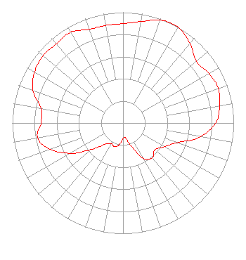 | ||||||||||||||||||
| Azimuth | Ratio | Azimuth | Ratio | Azimuth | Ratio | Azimuth | Ratio | ||||||||||||
| 0 | 0.897 | 10 | 0.931 | 20 | 0.987 | 25 | 1.000 | ||||||||||||
| 30 | 0.998 | 40 | 0.940 | 50 | 0.864 | 60 | 0.897 | ||||||||||||
| 70 | 0.915 | 80 | 0.888 | 90 | 0.837 | 100 | 0.713 | ||||||||||||
| 110 | 0.520 | 120 | 0.431 | 130 | 0.377 | 140 | 0.412 | ||||||||||||
| 150 | 0.369 | 160 | 0.223 | 170 | 0.138 | 180 | 0.139 | ||||||||||||
| 190 | 0.202 | 200 | 0.226 | 210 | 0.216 | 220 | 0.252 | ||||||||||||
| 230 | 0.373 | 240 | 0.549 | 250 | 0.698 | 260 | 0.783 | ||||||||||||
| 270 | 0.740 | 280 | 0.750 | 290 | 0.865 | 300 | 0.922 | ||||||||||||
| 310 | 0.943 | 320 | 0.936 | 330 | 0.946 | 340 | 0.900 | ||||||||||||
| 350 | 0.895 | ||||||||||||||||||
Structure Registration Number 1037278 [ASR Heights Differ from W262AR Application] Structure Type: GTOWER Registered To: Nexstar Media Inc. Structure Address: 2075 Golden Crest Dr Birmingham, AL County Name: Jefferson County ASR Issued: 09/27/2023 Date Built: 08/19/2022 Site Elevation: 278.9 m (915 ft.) Structure Height: 328 m (1076 ft.) Height Overall: 345 m (1132 ft.) Overall Height AMSL: 623.9 m (2047 ft.) FAA Determination: 06/05/2023 FAA Study #: 2022-ASO-33905-OE Paint & Light FAA Chapters: 1, 3, 8, 17, 21 Continue As Is OM&L = PAINT/RED LIGHTS 33-29-02.0 N 86-48-21.0 W (NAD 83) 33-29-01.6 N 86-48-21.0 W (Converted to NAD 27) |
1406 E. Garden Lane Midland, TX 79701 Phone: 432-682-1485 | Date: 02/28/2019 Application Certifier LA PROMESA FOUNDATION 1406 E. Garden Lane Midland, TX 79701 Applicant KENT LONEY 1406 E. Garden Lane Midland, TX 79701 CHIEF ENGINEER DENNIS J. KELLY Law Office Of Dennis J. Kelly Post Office Box 41177 Washington, DC 20018-0577 | |||||||||||||||||