
FCCInfo.com
A Service of Cavell, Mertz & Associates, Inc.
(855) FCC-INFO
|
|
K206DF from 07/06/2006 K206DF from 08/11/2000 K206DF from 04/22/1999 K206DF from 10/19/1998 |
|
|
||||||||||||||||
|
|
K206DF Channel: 206D 89.1 MHz Talmage, California Service: FX - A translator or application for a translator. Facility ID: 91893 Fac. Service: FX Programming Delivery Method: Unspecified Status: License Application Accepted: 01/15/2009 Application Granted: 01/22/2009 File Number: BMLFT-20090115AHU License Expires: 00/00/0000 Prefix Type: This is a modification of license for a translator Application Type: Minor Modification FCC Website Links: LMS Facility Details This Application CDBS Application Other K206DF Applications Other K206DF Applications in CDBS Including Superseded Applications Mailing Address Correspondence for K206DF Correspondence related to application BMLFT-20090115AHU Service Contour - Open Street Map or USGS Map (60 dBu) Service Contour - KML / Google Earth (60 dBu) Class: D, A Noncommercial educational operating with no more than 10W Site Location: 39-06-56.6 N 123-14-00.0 W (NAD 83) Site Location: 39-06-57.0 N 123-13-56.0 W (Converted to NAD 27) Effective Radiated Power: 0 kW Horiz. ; 0.01 kW Vert. Transmitter Output Power: 0.007 kW Antenna Center HAAT: 0 m Horiz.; 306.5 m Vert. Antenna Center AMSL: 0 m Horiz.; 773 m Vert. Antenna Center HAG: 0 m Horiz.; 12 m Vert. Site Elevation: 761 m. (2497 ft.) Height Overall*: 21 m (69 ft.) (* As Filed In This Application, may differ from ASR Data, Below.) Directional Antenna Antenna Make/Model: None Antenna ID: 16130 Polarization:
| ||||||||||||||||||
| Antenna Data for Antenna Id: 16130 K206DF FX File: BMLFT-20090115AHU None - Service: FX Pattern and Field Values Include a 35° Clockwise Rotation | 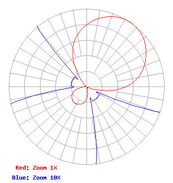 | ||||||||||||||||||
| Azimuth | Ratio | Azimuth | Ratio | Azimuth | Ratio | Azimuth | Ratio | ||||||||||||
| 5 | 0.840 | 15 | 0.923 | 25 | 0.980 | 35 | 1.000 | ||||||||||||
| 45 | 0.980 | 55 | 0.923 | 65 | 0.840 | 75 | 0.735 | ||||||||||||
| 85 | 0.600 | 95 | 0.410 | 105 | 0.185 | 115 | 0.030 | ||||||||||||
| 125 | 0.020 | 135 | 0.020 | 145 | 0.020 | 155 | 0.020 | ||||||||||||
| 165 | 0.025 | 175 | 0.125 | 185 | 0.195 | 195 | 0.230 | ||||||||||||
| 205 | 0.250 | 215 | 0.260 | 225 | 0.250 | 235 | 0.230 | ||||||||||||
| 245 | 0.195 | 255 | 0.125 | 265 | 0.025 | 275 | 0.020 | ||||||||||||
| 285 | 0.020 | 295 | 0.020 | 305 | 0.020 | 315 | 0.030 | ||||||||||||
| 325 | 0.185 | 335 | 0.410 | 345 | 0.600 | 355 | 0.735 | ||||||||||||
Structure Registration Number 1204202 [ASR Heights Differ from K206DF Application] Structure Type: TOWER Structure Address: Cleland Mountain Ukiah, CA County Name: Mendocino County ASR Issued: 11/08/1999 Date Built: 06/09/1999 Site Elevation: 760.5 m (2495 ft.) Structure Height: 21 m (69 ft.) Height Overall: 21 m (69 ft.) Overall Height AMSL: 781.5 m (2564 ft.) FAA Determination: 06/07/1999 FAA Study #: 99-AWP-0707-OE Paint & Light FAA Chapters: NONE Removed expiration date from determination. Scenario 1./jjs/case#635066 39-06-57.0 N 123-14-00.0 W (NAD 83) 39-06-57.4 N 123-13-56.0 W (Converted to NAD 27) |
P.o. Box 391 4002 N. 3300 E. Twin Falls, ID 83303 Phone: 208-733-3133 | Date: 01/15/2009 Application Certifier CALVARY CHAPEL OF TWIN FALLS, INC. Po Box 391 Twin Falls, ID 83303 Applicant LOIS MILLS Po Box 391 Twin Falls, ID 83303 APPLICATIONS TECHNICIAN CARY TEPPER Booth, Freret, Imlay And Tepper, Pc 7900 Wisconsin Ave, Suite 304 Bethesda, MD 20814 | |||||||||||||||||