
FCCInfo.com
A Service of Cavell, Mertz & Associates, Inc.
(855) FCC-INFO
|
|
KHTQ from 09/23/1991 KHTQ from 05/11/1989 |
|  |
|
|||||||||||||||||||||||||||
|
|
KHTQ Channel: 233C 94.5 MHz Hayden, Idaho Service: FM - A full-service FM station or application. Facility ID: 49244 Fac. Service: FM Status: License Application Accepted: 11/09/1999 Application Granted: 01/12/2000 File Number: BLH-19991103AAZ License Expires: 00/00/0000 Prefix Type: This is a license for a commercial FM station Application Type: License To Cover FCC Website Links: LMS Facility Details This Application CDBS Application Other KHTQ Applications Other KHTQ Applications in CDBS Including Superseded Applications Mailing Address Correspondence for KHTQ Correspondence related to application BLH-19991103AAZ Service Contour - Open Street Map or USGS Map (60 dBu) Service Contour - KML / Google Earth (60 dBu) Public Inspection Files Facility Type: FM STATION Class: C, A Zone II station; with exactly 100kW ERP and a class contour distance 72km-92km Site Location: 47-39-33.6 N 116-57-51.7 W (NAD 83) Site Location: 47-39-34.0 N 116-57-48.0 W (Converted to NAD 27) Effective Radiated Power: 83 kW Transmitter Output Power: 23 kW Antenna Center HAAT: 665 m (2182 ft.) Antenna Center AMSL: 1475 m (4839 ft.) Antenna Center HAG: 146 m (479 ft.) Site Elevation: 1329 m. (4360 ft.) Height Overall*: 152 m (499 ft.) (* As Filed In This Application, may differ from ASR Data, Below.) Directional Antenna Antenna Make/Model: Shivley 6810-8R-SS-DA Antenna ID: 15607 Polarization:
| ||||||||||||||||||||||||||||||
| Antenna Data for Antenna Id: 15607 KHTQ FM File: BLH-19991103AAZ Shivley - 6810-8R-SS-DA Service: FM | 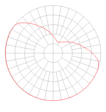 | ||||||||||||||||||||||||||||||
| Azimuth | Ratio | Azimuth | Ratio | Azimuth | Ratio | Azimuth | Ratio | ||||||||||||||||||||||||
| 0 | 0.360 | 10 | 0.300 | 20 | 0.257 | 30 | 0.257 | ||||||||||||||||||||||||
| 40 | 0.300 | 50 | 0.360 | 60 | 0.450 | 70 | 0.550 | ||||||||||||||||||||||||
| 80 | 0.670 | 90 | 0.820 | 100 | 0.960 | 110 | 1.000 | ||||||||||||||||||||||||
| 120 | 1.000 | 130 | 1.000 | 140 | 1.000 | 150 | 1.000 | ||||||||||||||||||||||||
| 160 | 1.000 | 170 | 1.000 | 180 | 1.000 | 190 | 1.000 | ||||||||||||||||||||||||
| 200 | 1.000 | 210 | 1.000 | 220 | 1.000 | 230 | 1.000 | ||||||||||||||||||||||||
| 240 | 1.000 | 250 | 1.000 | 260 | 1.000 | 270 | 1.000 | ||||||||||||||||||||||||
| 280 | 1.000 | 290 | 1.000 | 300 | 1.000 | 310 | 0.960 | ||||||||||||||||||||||||
| 320 | 0.820 | 330 | 0.670 | 340 | 0.550 | 350 | 0.450 | ||||||||||||||||||||||||
Structure Registration Number 1035499 [ASR Heights Differ from KHTQ Application] Structure Type: TOWER Registered To: QueenB Radio, Inc. Structure Address: Blossom Mountain Near Post Falls, ID County Name: Kootenai County ASR Issued: 09/23/2008 Date Built: 10/08/1999 Site Elevation: 1328.9 m (4360 ft.) Structure Height: 164.6 m (540 ft.) Height Overall: 164.6 m (540 ft.) Overall Height AMSL: 1493.5 m (4900 ft.) FAA Determination: 04/15/2008 FAA Study #: 2008-ANM-330-OE FAA Circular #: 70/7460-1K Paint & Light FAA Chapters: 4, 8, 12 PRIOR STUDY 1997-ANM-1397-OE 47-39-33.6 N 116-57-51.7 W (NAD 83) 47-39-34.0 N 116-57-48.0 W (Converted to NAD 27) |
500 West Boone Avenue Spokane, WA 99201 Phone: 509-324-4000 Corporation | Date: 11/03/1999 Application Certifier QUEENB RADIO, INC. 500 West Boone Avenue Spokane, WA 99201 Applicant TECHNICAL DIRECTOR | |||||||||||||||||||||||||||||
|
| ||||||||||||||||||||||||||||||