
FCCInfo.com
A Service of Cavell, Mertz & Associates, Inc.
(855) FCC-INFO
|
|
|
|  |
|
||||||||||||||||||
|
|
WBCY Channel: 208B1 89.5 MHz Archbold, Ohio Service: FM - A full-service FM station or application. Facility ID: 64657 Fac. Service: FM Status: License Application Accepted: 12/05/2005 Application Granted: 12/20/2005 File Number: BLED-20051205AAM License Expires: 00/00/0000 Prefix Type: This is a license for a noncommercial educational FM station Application Type: License To Cover FCC Website Links: LMS Facility Details This Application CDBS Application Other WBCY Applications Other WBCY Applications in CDBS Including Superseded Applications Mailing Address Correspondence for WBCY Correspondence related to application BLED-20051205AAM Service Contour - Open Street Map or USGS Map (60 dBu) Service Contour - KML / Google Earth (60 dBu) Public Inspection Files Facility Type: NON-COMMERCIAL EDUC. FM Class: B1, A Zone I or I-A station; with 6kW-25kW ERP and a class contour distance 28km-39km Site Location: 41-28-59.2 N 84-16-57.8 W (NAD 83) Site Location: 41-28-59.0 N 84-16-58.0 W (Converted to NAD 27) Effective Radiated Power: 20 kW Transmitter Output Power: 6.29 kW Antenna Center HAAT: 96 m (315 ft.) Antenna Center AMSL: 317 m (1040 ft.) Antenna Center HAG: 91 m (299 ft.) Site Elevation: 226 m. (741 ft.) Height Overall*: 102 m (335 ft.) (* As Filed In This Application, may differ from ASR Data, Below.) Directional Antenna Antenna Make/Model: Electronics Research Inc. LP-8C-DA-HW, 8 sections, .5 wavelength spaced Antenna ID: 71066 Polarization:
| |||||||||||||||||||||
| Antenna Data for Antenna Id: 71066 WBCY FM File: BLED-20051205AAM Electronics Research Inc. - LP-8C-DA-HW, 8 sections, .5 wavelength spaced Service: FM | 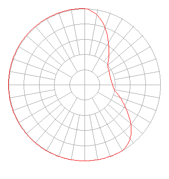 | |||||||||||||||||||||
| Azimuth | Ratio | Azimuth | Ratio | Azimuth | Ratio | Azimuth | Ratio | |||||||||||||||
| 0 | 1.000 | 10 | 0.930 | 20 | 0.793 | 30 | 0.630 | |||||||||||||||
| 40 | 0.500 | 50 | 0.400 | 60 | 0.370 | 70 | 0.355 | |||||||||||||||
| 80 | 0.355 | 90 | 0.370 | 100 | 0.400 | 110 | 0.500 | |||||||||||||||
| 120 | 0.630 | 130 | 0.793 | 140 | 0.930 | 150 | 1.000 | |||||||||||||||
| 160 | 1.000 | 170 | 1.000 | 180 | 1.000 | 190 | 1.000 | |||||||||||||||
| 200 | 1.000 | 210 | 1.000 | 220 | 1.000 | 230 | 1.000 | |||||||||||||||
| 240 | 1.000 | 250 | 1.000 | 260 | 1.000 | 270 | 1.000 | |||||||||||||||
| 280 | 1.000 | 290 | 1.000 | 300 | 1.000 | 310 | 1.000 | |||||||||||||||
| 320 | 1.000 | 330 | 1.000 | 340 | 1.000 | 350 | 1.000 | |||||||||||||||
Structure Registration Number 1015721 Structure Type: TOWER Registered To: Taylor University Broadcasting, Inc. Structure Address: 753 Twp Rd W21 Archbold, OH County Name: Henry County ASR Issued: 05/25/2011 Date Built: 11/10/1992 Site Elevation: 225.6 m (740 ft.) Structure Height: 102 m (335 ft.) Height Overall: 102.1 m (335 ft.) Overall Height AMSL: 327.7 m (1075 ft.) FAA Determination: 08/28/2005 FAA Study #: 2005-AGL-4014-OE FAA Circular #: 70/7460-1K Paint & Light FAA Chapters: 4, 8, 12 PRIOR STUDY 1991-AGL-726-OE 41-28-58.8 N 84-16-58.3 W (NAD 83) 41-28-58.6 N 84-16-58.5 W (Converted to NAD 27) |
1115 West Rudisill Blvd Fort Wayne, IN 46807 Phone: 260-745-0576 | Date: 12/05/2005 Application Certifier TAYLOR UNIVERSITY BROADCASTING, INC. 1025 W. Rudisill Blvd. Fort Wayne, IN 46807 Applicant WAYNE S. REESE Munn-reese, Inc. Po Box 220, 385 Airport Drive Coldwater, MI 49036-0220 CONSULTING ENGINEER MATTHEW H. MCCORMICK, LLP Reddy, Begley & Mccormick, Llp | ||||||||||||||||||||
| ||||||||||||||||||||||