
FCCInfo.com
A Service of Cavell, Mertz & Associates, Inc.
(855) FCC-INFO
|
|
KGSF from 03/11/1999 |
|
|
||||||||||||||||
|
|
KGSF Channel: 204C3 88.7 MHz Huntsville, Arkansas Service: FM - A full-service FM station or application. Facility ID: 92987 Fac. Service: FM Status: License Application Accepted: 08/19/2013 Application Granted: 10/22/2013 File Number: BLED-20130819ACA License Expires: 00/00/0000 Prefix Type: This is a license for a noncommercial educational FM station Application Type: License To Cover FCC Website Links: LMS Facility Details This Application CDBS Application Other KGSF Applications Other KGSF Applications in CDBS Including Superseded Applications Mailing Address Correspondence for KGSF Correspondence related to application BLED-20130819ACA Service Contour - Open Street Map or USGS Map (60 dBu) Service Contour - KML / Google Earth (60 dBu) Public Inspection Files Facility Type: NON-COMMERCIAL EDUC. FM Class: C3, A Zone II station; with 6kW-25kW ERP and a class contour distance 28km-39km Site Location: 36-21-38.3 N 93-44-54.7 W (NAD 83) Site Location: 36-21-38.0 N 93-44-54.0 W (Converted to NAD 27) Effective Radiated Power: 0 kW Horiz. ; 5 kW Vert. Transmitter Output Power: 2.571 kW Antenna Center HAAT: 0 m Horiz.; 181.5 m Vert. Antenna Center AMSL: 0 m Horiz.; 571 m Vert. Antenna Center HAG: 0 m Horiz.; 71 m Vert. Calculated Site Elevation: m. Height Overall*: 81 m (266 ft.) (* As Filed In This Application, may differ from ASR Data, Below.) Directional Antenna Antenna Make/Model: Propagation System Inc FMV-2-HWS-DA, 2 sections, .5 wavelength spaced Antenna ID: 113475 Polarization:
| ||||||||||||||||||
| Antenna Data for Antenna Id: 113475 KGSF FM File: BLED-20130819ACA Propagation System Inc - FMV-2-HWS-DA, 2 sections, .5 wavelength spaced Service: FM | 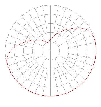 | ||||||||||||||||||
| Azimuth | Ratio | Azimuth | Ratio | Azimuth | Ratio | Azimuth | Ratio | ||||||||||||
| 0 | 0.244 | 10 | 0.306 | 20 | 0.386 | 30 | 0.486 | ||||||||||||
| 40 | 0.611 | 50 | 0.769 | 60 | 0.918 | 70 | 0.989 | ||||||||||||
| 80 | 1.000 | 90 | 1.000 | 100 | 1.000 | 110 | 1.000 | ||||||||||||
| 120 | 1.000 | 130 | 1.000 | 140 | 1.000 | 150 | 1.000 | ||||||||||||
| 160 | 1.000 | 170 | 1.000 | 180 | 1.000 | 190 | 1.000 | ||||||||||||
| 200 | 1.000 | 210 | 1.000 | 220 | 1.000 | 230 | 1.000 | ||||||||||||
| 240 | 1.000 | 250 | 1.000 | 260 | 0.973 | 270 | 0.873 | ||||||||||||
| 280 | 0.718 | 290 | 0.570 | 300 | 0.453 | 310 | 0.360 | ||||||||||||
| 320 | 0.286 | 330 | 0.227 | 340 | 0.193 | 350 | 0.201 | ||||||||||||
Structure Registration Number 1037669 [ASR Heights Differ from KGSF Application] Structure Type: TOWER Registered To: K2 Towers III, LLC Structure Address: 1.8 Mi S Jct Hwys 23 & 62 Eureka Springs, AR County Name: Carroll County ASR Issued: 03/04/2024 Date Built: 12/08/1995 Site Elevation: 500 m (1640 ft.) Structure Height: 73.1 m (240 ft.) Height Overall: 81.4 m (267 ft.) Overall Height AMSL: 581.4 m (1907 ft.) FAA Determination: 06/13/1995 FAA Study #: 95-ASW-0590-OE FAA Circular #: 70/7460-1H Paint & Light FAA Chapters: 3, 4, 5, 13 36-21-38.0 N 93-44-55.0 W (NAD 83) 36-21-37.7 N 93-44-54.3 W (Converted to NAD 27) |
4002 N. 3300 E. Twin Falls, ID 83301 Phone: 208-734-6633 Not-for-Profit | Date: 08/19/2013 Application Certifier CALVARY CHAPEL OF TWIN FALLS, INC. Po Box 391 Twin Falls, ID 83303 Applicant LOIS MILLS Po Box 391 Twin Falls, ID 83303 APPLICATION TECHNITION LOIS MILLS Christian Broadcasting Of Idaho, Inc. | |||||||||||||||||