
FCCInfo.com
A Service of Cavell, Mertz & Associates, Inc.
(855) FCC-INFO
|
|
W288BU from 09/29/2004 |
|
|
||||||||||||||||
|
|
W288BU Channel: 288D 105.5 MHz Durham, North Carolina Service: FX - A translator or application for a translator. Facility ID: 154202 Fac. Service: FX Programming Delivery Method: Unspecified Status: License Application Accepted: 04/03/2015 Application Granted: 04/13/2015 File Number: BLFT-20150403AAM License Expires: 00/00/0000 Prefix Type: This is a license for a translator Application Type: License To Cover FCC Website Links: LMS Facility Details This Application CDBS Application Other W288BU Applications Other W288BU Applications in CDBS Including Superseded Applications Mailing Address Correspondence for W288BU Correspondence related to application BLFT-20150403AAM Service Contour - Open Street Map or USGS Map (60 dBu) Service Contour - KML / Google Earth (60 dBu) Class: D, A Noncommercial educational operating with no more than 10W Site Location: 35-59-54.5 N 78-51-20.0 W (NAD 83) Site Location: 35-59-54.0 N 78-51-21.0 W (Converted to NAD 27) Effective Radiated Power: 0.25 kW Transmitter Output Power: 0.8 kW Antenna Center HAAT: 130.6 m Horiz.; 0 m Vert. Antenna Center AMSL: 235 m (771 ft.) Antenna Center HAG: 116 m (381 ft.) Site Elevation: 119 m. (390 ft.) Height Overall*: 128 m (420 ft.) (* As Filed In This Application, may differ from ASR Data, Below.) Directional Antenna Antenna Make/Model: None Antenna ID: 109775 Polarization:
| ||||||||||||||||||
| Antenna Data for Antenna Id: 109775 W288BU FX File: BLFT-20150403AAM None - Service: FX | 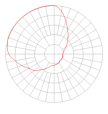 | ||||||||||||||||||
| Azimuth | Ratio | Azimuth | Ratio | Azimuth | Ratio | Azimuth | Ratio | ||||||||||||
| 0 | 1.000 | 10 | 0.893 | 20 | 0.710 | 30 | 0.564 | ||||||||||||
| 40 | 0.448 | 50 | 0.356 | 60 | 0.283 | 70 | 0.224 | ||||||||||||
| 80 | 0.195 | 90 | 0.178 | 100 | 0.180 | 110 | 0.188 | ||||||||||||
| 120 | 0.182 | 130 | 0.189 | 140 | 0.184 | 150 | 0.209 | ||||||||||||
| 160 | 0.216 | 170 | 0.224 | 180 | 0.235 | 190 | 0.242 | ||||||||||||
| 200 | 0.287 | 210 | 0.354 | 220 | 0.428 | 230 | 0.532 | ||||||||||||
| 240 | 0.591 | 250 | 0.705 | 260 | 0.810 | 270 | 0.932 | ||||||||||||
| 280 | 0.973 | 290 | 1.000 | 300 | 1.000 | 310 | 1.000 | ||||||||||||
| 320 | 1.000 | 330 | 1.000 | 340 | 1.000 | 350 | 1.000 | ||||||||||||
Structure Registration Number 1005705 [ASR Heights Differ from W288BU Application] Structure Type: GTOWER Registered To: SBA GC Towers, LLC Structure Address: 503 Junction Road (nc15958-a #2) Durham, NC County Name: Durham County ASR Issued: 06/06/2014 Date Built: 06/27/1994 Site Elevation: 109.1 m (358 ft.) Structure Height: 122.2 m (401 ft.) Height Overall: 127.1 m (417 ft.) Overall Height AMSL: 236.2 m (775 ft.) FAA Determination: 05/30/2014 FAA Study #: 2014-ASO-4797-OE FAA Circular #: 70/7460-1K Paint & Light FAA Chapters: 3, 4, 6, 12 PRIOR STUDY 1994-ASO-751-OE 35-59-55.0 N 78-51-21.0 W (NAD 83) 35-59-54.5 N 78-51-22.0 W (Converted to NAD 27) |
4405 Providence Lane Suite D Winston-salem, NC 27106 Phone: 336-759-0363 Corporation | Date: 04/03/2015 Application Certifier TRUTH BROADCASTING CORPORATION 4405 Providence Lane Suite D Winston-salem, NC 27106 Applicant CARL E. GLUCK Carl T. Jones Corp 7901 Yarnwood Court Springfield, VA 22153-2899 TECHNICAL CONSULTANT DAVINA SASHKIN, ESQ. Fletcher, Heald & Hildreth, Plc 1300 North 17th Street 11th Floor Arlington, VA 22209 | |||||||||||||||||