
FCCInfo.com
A Service of Cavell, Mertz & Associates, Inc.
(855) FCC-INFO
|
|
W227CZ from 12/04/2013 |
|
|
||||||||||||||||
|
|
W227CZ Channel: 227D 93.3 MHz Durham, North Carolina Service: FX - A translator or application for a translator. Facility ID: 142785 Fac. Service: FX Programming Delivery Method: Unspecified Status: License Application Accepted: 12/02/2016 Application Granted: 12/08/2016 File Number: BLFT-20161202AAJ License Expires: 00/00/0000 Prefix Type: This is a license for a translator Application Type: License To Cover FCC Website Links: LMS Facility Details This Application CDBS Application Other W227CZ Applications Other W227CZ Applications in CDBS Including Superseded Applications Mailing Address Correspondence for W227CZ Correspondence related to application BLFT-20161202AAJ Service Contour - Open Street Map or USGS Map (60 dBu) Service Contour - KML / Google Earth (60 dBu) Class: D, A Noncommercial educational operating with no more than 10W Site Location: 36-06-13.5 N 78-57-56.0 W (NAD 83) Site Location: 36-06-13.0 N 78-57-57.0 W (Converted to NAD 27) Effective Radiated Power: 0.2 kW Transmitter Output Power: 0.125 kW Antenna Center HAAT: 0 m Antenna Center AMSL: 335 m (1099 ft.) Antenna Center HAG: 134 m (440 ft.) Site Elevation: 201 m. (659 ft.) Height Overall*: 152 m (499 ft.) (* As Filed In This Application, may differ from ASR Data, Below.) Directional Antenna Antenna Make/Model: None Antenna ID: 123049 Polarization:
| ||||||||||||||||||
| Antenna Data for Antenna Id: 123049 W227CZ FX File: BLFT-20161202AAJ None - Service: FX | 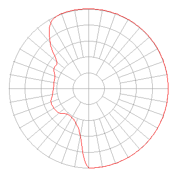 | ||||||||||||||||||
| Azimuth | Ratio | Azimuth | Ratio | Azimuth | Ratio | Azimuth | Ratio | ||||||||||||
| 0 | 1.000 | 10 | 1.000 | 20 | 1.000 | 30 | 1.000 | ||||||||||||
| 40 | 1.000 | 50 | 1.000 | 60 | 1.000 | 70 | 1.000 | ||||||||||||
| 80 | 1.000 | 90 | 1.000 | 100 | 1.000 | 110 | 1.000 | ||||||||||||
| 120 | 1.000 | 130 | 1.000 | 140 | 1.000 | 150 | 1.000 | ||||||||||||
| 160 | 1.000 | 170 | 1.000 | 180 | 1.000 | 190 | 0.600 | ||||||||||||
| 200 | 0.465 | 210 | 0.420 | 220 | 0.420 | 230 | 0.480 | ||||||||||||
| 240 | 0.500 | 250 | 0.500 | 260 | 0.460 | 270 | 0.440 | ||||||||||||
| 280 | 0.440 | 290 | 0.450 | 300 | 0.500 | 310 | 0.520 | ||||||||||||
| 320 | 0.750 | 330 | 0.950 | 340 | 1.000 | 350 | 1.000 | ||||||||||||
Structure Registration Number 1267862 Structure Type: GTOWER Registered To: New Century Media Group, LLC - New102.5 Structure Address: N Of Sr 1453; 0.5 Km E Of Intersection Of Sr1453 And Sr 1452 Durham, NC County Name: Durham County ASR Issued: 06/24/2020 Date Built: 09/23/2010 Site Elevation: 200.9 m (659 ft.) Structure Height: 151.5 m (497 ft.) Height Overall: 152.4 m (500 ft.) Overall Height AMSL: 353.3 m (1159 ft.) FAA Determination: 06/23/2020 FAA Study #: 2020-ASO-6852-OE FAA Circular #: 70/7460-1L Paint & Light FAA Chapters: 3, 4, 5, 12 PRIOR STUDY 2009-ASO-262-OE 36-06-13.7 N 78-57-55.7 W (NAD 83) 36-06-13.2 N 78-57-56.7 W (Converted to NAD 27) |
3012 Highwoods Blvd. Suite 201 Raleigh, NC 27602 Phone: 919-790-9392 | Date: 12/02/2016 Application Certifier EASTERN AIRWAVES, LLC 3012 Highwoods Blvd. Suite 201 Raleigh, NC 27604 Applicant TIMOTHY L. WARNER, P.E. Timothy L. Warner, Inc. Post Office Box 8045 Asheville, NC 28814-8045 TECHNICAL CONSULTANT COE W. RAMSEY Brooks, Pierce, Et. Al. Po Box 1800 Raleigh, NC 27602 | |||||||||||||||||