
FCCInfo.com
A Service of Cavell, Mertz & Associates, Inc.
(855) FCC-INFO
|
|
KAJC from 08/26/1998 |
|  |
|
|||||||||||||||
|
|
KAJC Channel: 211A 90.1 MHz Salem, Oregon Service: FM - A full-service FM station or application. Facility ID: 91565 Fac. Service: FM Status: License Application Accepted: 01/24/2005 Application Granted: 03/31/2005 File Number: BLED-20050124AHZ License Expires: 00/00/0000 Prefix Type: This is a license for a noncommercial educational FM station Application Type: License To Cover FCC Website Links: LMS Facility Details This Application CDBS Application Other KAJC Applications Other KAJC Applications in CDBS Including Superseded Applications Mailing Address Correspondence for KAJC Correspondence related to application BLED-20050124AHZ Service Contour - Open Street Map or USGS Map (60 dBu) Service Contour - KML / Google Earth (60 dBu) Public Inspection Files Facility Type: NON-COMMERCIAL EDUC. FM Class: A, A Zone I; I-A; or II station; with 0.1kW-6kW ERP and a class contour distance <=28km Site Location: 44-45-32.4 N 123-13-38.4 W (NAD 83) Site Location: 44-45-33.0 N 123-13-34.0 W (Converted to NAD 27) Effective Radiated Power: 0.56 kW Transmitter Output Power: 0.696 kW Antenna Center HAAT: 39 m (128 ft.) Antenna Center AMSL: 150 m (492 ft.) Antenna Center HAG: 44 m (144 ft.) Site Elevation: 106 m. (348 ft.) Height Overall*: 46 m (151 ft.) (* As Filed In This Application, may differ from ASR Data, Below.) Directional Antenna Antenna Make/Model: None Jampro JMPC-1 DA, 1 section Antenna ID: 40293 Polarization: | ||||||||||||||||||
| Antenna Data for Antenna Id: 40293 KAJC FM File: BLED-20050124AHZ None - Jampro JMPC-1 DA, 1 section Service: FM | 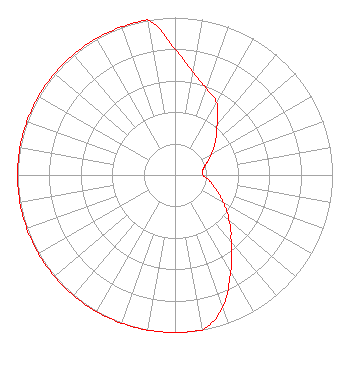 | ||||||||||||||||||
| Azimuth | Ratio | Azimuth | Ratio | Azimuth | Ratio | Azimuth | Ratio | ||||||||||||
| 0 | 0.800 | 10 | 0.662 | 20 | 0.584 | 30 | 0.529 | ||||||||||||
| 40 | 0.420 | 45 | 0.374 | 50 | 0.333 | 60 | 0.265 | ||||||||||||
| 70 | 0.210 | 80 | 0.179 | 90 | 0.178 | 100 | 0.224 | ||||||||||||
| 110 | 0.282 | 120 | 0.355 | 130 | 0.447 | 135 | 0.501 | ||||||||||||
| 140 | 0.562 | 150 | 0.708 | 160 | 0.891 | 170 | 1.000 | ||||||||||||
| 180 | 1.000 | 190 | 1.000 | 200 | 1.000 | 210 | 1.000 | ||||||||||||
| 220 | 1.000 | 225 | 1.000 | 230 | 1.000 | 240 | 1.000 | ||||||||||||
| 250 | 1.000 | 260 | 1.000 | 270 | 1.000 | 280 | 1.000 | ||||||||||||
| 290 | 1.000 | 300 | 1.000 | 310 | 1.000 | 315 | 1.000 | ||||||||||||
| 320 | 1.000 | 330 | 1.000 | 340 | 1.000 | 350 | 1.000 | ||||||||||||
Structure Registration Number 1040962 [ASR Heights Differ from KAJC Application] Structure Type: MTOWER Registered To: T-Mobile West Tower LLC Structure Address: 12035 Helmick Rd Monmouth, OR County Name: Polk County ASR Issued: 10/20/2020 Date Built: 09/04/2020 Site Elevation: 107.6 m (353 ft.) Structure Height: 50.6 m (166 ft.) Height Overall: 51.8 m (170 ft.) Overall Height AMSL: 159.4 m (523 ft.) FAA Determination: 10/19/2020 FAA Study #: 2020-ANM-5086-OE Paint & Light FAA Chapters: NONE PRIOR STUDY 2019-ANM-134-OE 44-45-31.5 N 123-13-38.0 W (NAD 83) 44-45-32.1 N 123-13-33.6 W (Converted to NAD 27) |
Independence, OR 97351 Phone: 717-507-3426 Not-for-Profit | Date: 01/24/2005 Application Certifier CSN INTERNATIONAL 4002 N. 3300 E. Twin Falls, ID 83301 Applicant LOIS MILLS 4002 N. 3300 E. Twin Falls, ID 83301 APPLICATIONS TECHNICIAN CARY S. TEPPER, ESQ. Booth, Freret, Imlay & Tepper, P.c. | |||||||||||||||||