
FCCInfo.com
A Service of Cavell, Mertz & Associates, Inc.
(855) FCC-INFO
|
|
|
|
|
||||||||||||||||
|
|
K265FM Channel: 265D 100.9 MHz Nephi, Utah Service: FX - A translator or application for a translator. Facility ID: 139646 Fac. Service: FX Programming Delivery Method: Unspecified Status: License Application Accepted: 08/15/2019 Application Granted: 08/28/2019 File Number: BLFT-20190815ABQ License Expires: 00/00/0000 Prefix Type: This is a license for a translator Application Type: License To Cover FCC Website Links: LMS Facility Details This Application CDBS Application Other K265FM Applications Other K265FM Applications in CDBS Including Superseded Applications Mailing Address Correspondence for K265FM Correspondence related to application BLFT-20190815ABQ Service Contour - Open Street Map or USGS Map (60 dBu) Service Contour - KML / Google Earth (60 dBu) Class: D, A Noncommercial educational operating with no more than 10W Site Location: 39-43-57.8 N 111-56-37.8 W (NAD 83) Site Location: 39-43-58.0 N 111-56-35.0 W (Converted to NAD 27) Effective Radiated Power: 0.25 kW Transmitter Output Power: 0.58 kW Antenna Center HAAT: 0 m Antenna Center AMSL: 1942 m (6371 ft.) Antenna Center HAG: 24 m (79 ft.) Site Elevation: 1918 m. (6293 ft.) Height Overall*: 138 m (453 ft.) (* As Filed In This Application, may differ from ASR Data, Below.) Directional Antenna Antenna Make/Model: None Antenna ID: 135147 Polarization:
| ||||||||||||||||||
| Antenna Data for Antenna Id: 135147 K265FM FX File: BLFT-20190815ABQ None - Service: FX Pattern and Field Values Include a 120° Clockwise Rotation | 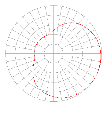 | ||||||||||||||||||
| Azimuth | Ratio | Azimuth | Ratio | Azimuth | Ratio | Azimuth | Ratio | ||||||||||||
| 0 | 0.479 | 10 | 0.557 | 20 | 0.650 | 30 | 0.737 | ||||||||||||
| 40 | 0.804 | 50 | 0.856 | 60 | 0.899 | 70 | 0.939 | ||||||||||||
| 80 | 0.963 | 90 | 0.978 | 100 | 0.989 | 110 | 0.995 | ||||||||||||
| 120 | 1.000 | 130 | 0.995 | 140 | 0.989 | 150 | 0.978 | ||||||||||||
| 160 | 0.963 | 170 | 0.939 | 180 | 0.899 | 190 | 0.856 | ||||||||||||
| 200 | 0.804 | 210 | 0.737 | 220 | 0.650 | 230 | 0.557 | ||||||||||||
| 240 | 0.479 | 250 | 0.423 | 260 | 0.399 | 270 | 0.403 | ||||||||||||
| 280 | 0.398 | 290 | 0.404 | 300 | 0.401 | 310 | 0.404 | ||||||||||||
| 320 | 0.398 | 330 | 0.403 | 340 | 0.399 | 350 | 0.423 | ||||||||||||
Structure Registration Number 1210829 [ASR Heights Differ from K265FM Application] Structure Type: GTOWER Registered To: AT&T Mobility Spectrum LLC Structure Address: 3.85km North Of Hwy 132, 6.4km West Of Nephi Airort Nephi, UT County Name: Juab County ASR Issued: 11/01/2022 Date Built: 06/22/2010 Site Elevation: 1917.5 m (6291 ft.) Structure Height: 136.2 m (447 ft.) Height Overall: 137.8 m (452 ft.) Overall Height AMSL: 2055.3 m (6743 ft.) FAA Determination: 09/02/2016 FAA Study #: 2016-ANM-2731-OE FAA Circular #: 70/7460-1L Paint & Light FAA Chapters: 4, 8, 12 PRIOR STUDY 2011-ANM-2943-OE 39-43-58.0 N 111-56-37.4 W (NAD 83) 39-43-58.2 N 111-56-34.6 W (Converted to NAD 27) |
P.o. Box 40 Manti, UT 84642 Phone: 435-835-8141 | Date: 08/15/2019 Application Certifier SANPETE COUNTY BROADCASTING CO. P.o. Box 40 Manti, UT 84642 Applicant KEVIN TERRY 2520 Airport Rd Helena, MT 59601 TECHNICAL CONSULTANT SHELLEY SADOWSKY Shelley Sadowsky, Llc 5938 Dorchester Way Rockville, MD 20852 | |||||||||||||||||