
FCCInfo.com
A Service of Cavell, Mertz & Associates, Inc.
(855) FCC-INFO
|
|
|
|
|
||||||||||||||||
|
|
W272EE Channel: 272D 102.3 MHz Zanesville, Ohio Service: FX - A translator or application for a translator. Facility ID: 201025 Fac. Service: FX Programming Delivery Method: Unspecified Status: License Application Accepted: 08/07/2018 Application Granted: 08/15/2018 File Number: BLFT-20180807ACT License Expires: 00/00/0000 Prefix Type: This is a license for a translator Application Type: License To Cover FCC Website Links: LMS Facility Details This Application CDBS Application Other W272EE Applications Other W272EE Applications in CDBS Including Superseded Applications Mailing Address Correspondence for W272EE Correspondence related to application BLFT-20180807ACT Service Contour - Open Street Map or USGS Map (60 dBu) Service Contour - KML / Google Earth (60 dBu) Class: D, A Noncommercial educational operating with no more than 10W Site Location: 39-55-42.0 N 81-59-07.0 W (NAD 83) Site Location: 39-55-41.8 N 81-59-07.5 W (Converted to NAD 27) Effective Radiated Power: 0.25 kW Transmitter Output Power: 0.348 kW Antenna Center HAAT: 0 m Antenna Center AMSL: 405 m (1329 ft.) Antenna Center HAG: 128 m (420 ft.) Site Elevation: 277 m. (909 ft.) Height Overall*: 153 m (502 ft.) (* As Filed In This Application, may differ from ASR Data, Below.) Directional Antenna Antenna Make/Model: None Antenna ID: 131872 Polarization:
| ||||||||||||||||||
| Antenna Data for Antenna Id: 131872 W272EE FX File: BLFT-20180807ACT None - Service: FX | 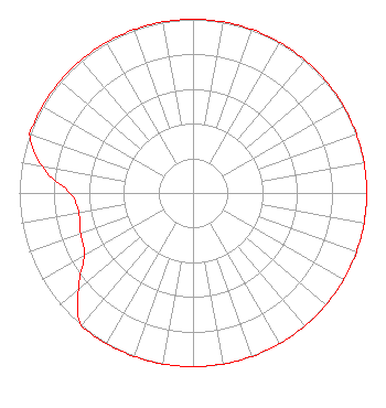 | ||||||||||||||||||
| Azimuth | Ratio | Azimuth | Ratio | Azimuth | Ratio | Azimuth | Ratio | ||||||||||||
| 0 | 1.000 | 10 | 1.000 | 20 | 1.000 | 30 | 1.000 | ||||||||||||
| 40 | 1.000 | 50 | 1.000 | 60 | 1.000 | 70 | 1.000 | ||||||||||||
| 80 | 1.000 | 90 | 1.000 | 100 | 1.000 | 110 | 1.000 | ||||||||||||
| 120 | 1.000 | 130 | 1.000 | 140 | 1.000 | 150 | 1.000 | ||||||||||||
| 160 | 1.000 | 170 | 1.000 | 180 | 1.000 | 190 | 1.000 | ||||||||||||
| 200 | 1.000 | 210 | 1.000 | 220 | 1.000 | 230 | 0.861 | ||||||||||||
| 240 | 0.722 | 250 | 0.689 | 260 | 0.667 | 270 | 0.709 | ||||||||||||
| 280 | 0.882 | 290 | 1.000 | 300 | 1.000 | 310 | 1.000 | ||||||||||||
| 320 | 1.000 | 330 | 1.000 | 340 | 1.000 | 350 | 1.000 | ||||||||||||
Structure Registration Number 1232923 Structure Type: GTOWER Registered To: Marquee Broadcasting Ohio, Inc. Structure Address: 629 Downard Road Zanesville, OH County Name: Muskingum County ASR Issued: 04/03/2023 Date Built: 06/19/2002 Site Elevation: 276.8 m (908 ft.) Structure Height: 140.2 m (460 ft.) Height Overall: 153.3 m (503 ft.) Overall Height AMSL: 430.1 m (1411 ft.) FAA Determination: 03/31/2023 FAA Study #: 2022-AGL-25470-OE FAA Circular #: 70/7460-1M Paint & Light FAA Chapters: 3, 4, 5, 15 PRIOR STUDY 2001-AGL-5942-OE 39-55-41.7 N 81-59-06.8 W (NAD 83) 39-55-41.5 N 81-59-07.3 W (Converted to NAD 27) |
629 Downard Road Zanesville, OH 43701 Phone: 301-661-9610 Corporation | Date: 08/07/2018 Application Certifier SOUTHEASTERN OHIO BROADCASTING SYSTEM, INC. 629 Downard Road Zanesville, OH 43701 Applicant KEVIN J. BUENTE 629 Downard Road Zanesville, OH 43701 CHIEF ENGINEER J. RICHARD CARR, ESQ. J. Richard Carr, Esq. 5528 Trent Street Chevy Chase, MD 20815 | |||||||||||||||||