
FCCInfo.com
A Service of Cavell, Mertz & Associates, Inc.
(855) FCC-INFO
|
|
KOJO from 09/26/1989 |
|
|
|||||||||||||||||||
|
|
KOJO Channel: 216C3 91.1 MHz Lake Charles, Louisiana Service: FM - A full-service FM station or application. Facility ID: 39891 Fac. Service: FM Status: License Application Accepted: 08/20/2004 Application Granted: 12/10/2004 File Number: BLED-20040820AAJ License Expires: 00/00/0000 Prefix Type: This is a license for a noncommercial educational FM station Application Type: License To Cover FCC Website Links: LMS Facility Details This Application CDBS Application Other KOJO Applications Other KOJO Applications in CDBS Including Superseded Applications Mailing Address Correspondence for KOJO Correspondence related to application BLED-20040820AAJ Service Contour - Open Street Map or USGS Map (60 dBu) Service Contour - KML / Google Earth (60 dBu) Public Inspection Files Facility Type: NON-COMMERCIAL EDUC. FM Class: C3, A Zone II station; with 6kW-25kW ERP and a class contour distance 28km-39km Site Location: 30-12-07.7 N 92-56-47.5 W (NAD 83) Site Location: 30-12-07.0 N 92-56-47.0 W (Converted to NAD 27) Effective Radiated Power: 4 kW Horiz. ; 14 kW Vert. Transmitter Output Power: 3.166 kW Antenna Center HAAT: 118 m (387 ft.) Antenna Center AMSL: 123 m (404 ft.) Antenna Center HAG: 118 m (387 ft.) Site Elevation: 5 m. (16 ft.) Height Overall*: 152 m (499 ft.) (* As Filed In This Application, may differ from ASR Data, Below.) Directional Antenna Antenna Make/Model: Shivley 6810-4 H/V-DA Antenna ID: 68411 Polarization:
| |||||||||||||||||||||
| Antenna Data for Antenna Id: 68411 KOJO FM File: BLED-20040820AAJ Shivley - 6810-4 H/V-DA Service: FM | 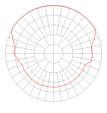 | |||||||||||||||||||||
| Azimuth | Ratio | Azimuth | Ratio | Azimuth | Ratio | Azimuth | Ratio | |||||||||||||||
| 0 | 1.000 | 10 | 1.000 | 20 | 1.000 | 30 | 1.000 | |||||||||||||||
| 40 | 1.000 | 50 | 1.000 | 60 | 1.000 | 70 | 0.900 | |||||||||||||||
| 80 | 0.800 | 90 | 0.800 | 100 | 0.800 | 110 | 0.700 | |||||||||||||||
| 120 | 0.700 | 130 | 0.700 | 140 | 0.700 | 150 | 0.700 | |||||||||||||||
| 160 | 0.700 | 170 | 0.700 | 180 | 0.700 | 190 | 0.700 | |||||||||||||||
| 200 | 0.700 | 210 | 0.700 | 220 | 0.700 | 230 | 0.700 | |||||||||||||||
| 240 | 0.700 | 250 | 0.700 | 260 | 0.750 | 270 | 0.810 | |||||||||||||||
| 280 | 0.820 | 290 | 0.900 | 300 | 1.000 | 310 | 1.000 | |||||||||||||||
| 320 | 1.000 | 330 | 1.000 | 340 | 1.000 | 350 | 1.000 | |||||||||||||||
Structure Registration Number 1015162 Structure Type: TOWER Registered To: Townsquare Media Lake Charles, LLC Structure Address: 1.7 Km W Of La Hwy 101 On The N Side Of Clifton Rd Lacassine, LA County Name: Jefferson Davis Parish ASR Issued: 03/24/2021 Date Built: 08/24/1998 Site Elevation: 4.6 m (15 ft.) Structure Height: 151 m (495 ft.) Height Overall: 152 m (499 ft.) Overall Height AMSL: 156.6 m (514 ft.) FAA Determination: 07/27/1996 FAA Study #: 96-ASW-0801-OE FAA Circular #: 70/7460-1H Paint & Light FAA Chapters: 3, 4, 5, 13 30-12-08.0 N 92-56-48.0 W (NAD 83) 30-12-07.3 N 92-56-47.5 W (Converted to NAD 27) |
601 Washington St Alexandria, LA 71301 Phone: 703-437-8400 | Date: 08/20/2004 Application Certifier RADIO MARIA, INC. 601 Washington Street Alexandria, LA 71301 Applicant JEFFERSON G. BROCK Graham Brock, Inc. P.o. Box 24466 St. Simons Island, GA 31522-7466 TECHNICAL CONSULTANT JOHN C. TRENT, ESQUIRE Putbrese Hunsaker & Trent, P.c. | ||||||||||||||||||||
| ||||||||||||||||||||||