
FCCInfo.com
A Service of Cavell, Mertz & Associates, Inc.
(855) FCC-INFO
|
|
WRWR from 12/04/2013 WRWR from 12/16/2009 WRWR from 03/15/2005 WRWR from 12/01/1978 |
|  |
|
|||||||||||||||
|
|
WRWR Channel: 298A 107.5 MHz Cochran, Georgia Service: FM - A full-service FM station or application. Facility ID: 26626 Fac. Service: FM Status: License 73.215 Station Application Accepted: 01/20/2010 Application Granted: 01/22/2010 File Number: BLH-20100120ACT License Expires: 00/00/0000 Prefix Type: This is a license for a commercial FM station Application Type: License To Cover FCC Website Links: LMS Facility Details This Application CDBS Application Other WRWR Applications Other WRWR Applications in CDBS Including Superseded Applications Mailing Address Correspondence for WRWR Correspondence related to application BLH-20100120ACT Service Contour - Open Street Map or USGS Map (60 dBu) Service Contour - KML / Google Earth (60 dBu) Public Inspection Files History Cards for WRWR Facility Type: FM STATION Class: A, A Zone I; I-A; or II station; with 0.1kW-6kW ERP and a class contour distance <=28km Site Location: 32-32-36.5 N 83-27-54.6 W (NAD 83) Site Location: 32-32-36.0 N 83-27-55.0 W (Converted to NAD 27) Effective Radiated Power: 4 kW Transmitter Output Power: 2.4 kW Antenna Center HAAT: 122.3 m (401 ft.) Antenna Center AMSL: 218.8 m (718 ft.) Antenna Center HAG: 112.7 m (370 ft.) Calculated Site Elevation: 106.1 m. (348 ft.) Height Overall*: 117.4 m (385 ft.) (* As Filed In This Application, may differ from ASR Data, Below.) Directional Antenna Antenna Make/Model: Shivley 6810-3SS Antenna ID: 93923 Polarization:
| ||||||||||||||||||
| Antenna Data for Antenna Id: 93923 WRWR FM File: BLH-20100120ACT Shivley - 6810-3SS Service: FM | 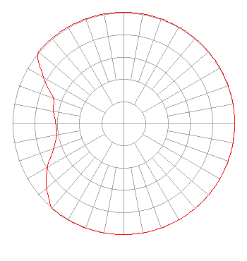 | ||||||||||||||||||
| Azimuth | Ratio | Azimuth | Ratio | Azimuth | Ratio | Azimuth | Ratio | ||||||||||||
| 0 | 1.000 | 10 | 1.000 | 20 | 1.000 | 30 | 1.000 | ||||||||||||
| 40 | 1.000 | 45 | 1.000 | 50 | 1.000 | 60 | 1.000 | ||||||||||||
| 70 | 1.000 | 80 | 1.000 | 90 | 1.000 | 100 | 1.000 | ||||||||||||
| 110 | 1.000 | 120 | 1.000 | 130 | 1.000 | 135 | 1.000 | ||||||||||||
| 140 | 1.000 | 150 | 1.000 | 160 | 1.000 | 170 | 1.000 | ||||||||||||
| 180 | 1.000 | 190 | 1.000 | 200 | 1.000 | 210 | 1.000 | ||||||||||||
| 220 | 1.000 | 225 | 0.950 | 230 | 0.900 | 240 | 0.790 | ||||||||||||
| 250 | 0.670 | 260 | 0.610 | 270 | 0.610 | 280 | 0.640 | ||||||||||||
| 290 | 0.675 | 300 | 0.832 | 310 | 1.000 | 315 | 1.000 | ||||||||||||
| 320 | 1.000 | 330 | 1.000 | 340 | 1.000 | 350 | 1.000 | ||||||||||||
Structure Registration Number 1243345 [ASR Heights Differ from WRWR Application] Structure Type: GTOWER Registered To: American Towers LLC Structure Address: 13862 Hwy 96 West (205019) Dry Branch, GA County Name: Twiggs County ASR Issued: 01/22/2020 Date Built: 07/05/2004 Site Elevation: 106 m (348 ft.) Structure Height: 116.1 m (381 ft.) Height Overall: 117.7 m (386 ft.) Overall Height AMSL: 223.7 m (734 ft.) FAA Determination: 11/04/2019 FAA Study #: 2019-ASO-29541-OE FAA Circular #: 70/7460-1L Paint & Light FAA Chapters: 4, 8, 12 PRIOR STUDY 2019-ASO-13937-OE 32-32-37.0 N 83-27-54.4 W (NAD 83) 32-32-36.5 N 83-27-54.8 W (Converted to NAD 27) |
6174 Highway 57 Macon, GA 31217 Phone: 404-307-8079 Limited Liability Company | Date: 01/20/2010 Application Certifier GEORGIA EAGLE BROADCASTING, INC. 6316 Peake Rd. Macon, GA 31210 Applicant DAN J. ALPERT The Law Office Of Dan J. Alpert RICHARD HAMILTON 111 N. Davis Dr. Warner Robins, GA 31093 CONSULTING ENGINEER | |||||||||||||||||
| |||||||||||||||||||