
FCCInfo.com
A Service of Cavell, Mertz & Associates, Inc.
(855) FCC-INFO
|
|
|
|
|
||||||||||||||||
|
|
W261BX Channel: 261D 100.1 MHz Birmingham, Alabama Service: FX - A translator or application for a translator. Facility ID: 150818 Fac. Service: FX Programming Delivery Method: Unspecified Status: License Application Accepted: 07/07/2015 Application Granted: 11/20/2015 File Number: BLFT-20150707ADF License Expires: 04/01/2028 Prefix Type: This is a license for a translator Application Type: License To Cover FCC Website Links: LMS Facility Details This Application CDBS Application Other W261BX Applications Other W261BX Applications in CDBS Including Superseded Applications Mailing Address Correspondence for W261BX Correspondence related to application BLFT-20150707ADF Service Contour - Open Street Map or USGS Map (60 dBu) Service Contour - KML / Google Earth (60 dBu) Class: D, A Noncommercial educational operating with no more than 10W Site Location: 33-29-02.4 N 86-48-21.0 W (NAD 83) Site Location: 33-29-02.0 N 86-48-21.0 W (Converted to NAD 27) Effective Radiated Power: 0.035 kW Transmitter Output Power: 0.128 kW Antenna Center HAAT: 0 m Antenna Center AMSL: 537 m (1762 ft.) Antenna Center HAG: 258 m (846 ft.) Site Elevation: 279 m. (915 ft.) Height Overall*: 346 m (1135 ft.) (* As Filed In This Application, may differ from ASR Data, Below.) Directional Antenna Antenna Make/Model: Shivley 6014 Antenna ID: 119412 Polarization: H
| ||||||||||||||||||
| Antenna Data for Antenna Id: 119412 W261BX FX File: BLFT-20150707ADF Shivley - 6014 Service: FX | 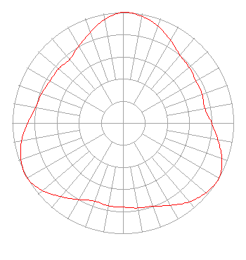 | ||||||||||||||||||
| Azimuth | Ratio | Azimuth | Ratio | Azimuth | Ratio | Azimuth | Ratio | ||||||||||||
| 0 | 1.000 | 10 | 0.980 | 20 | 0.930 | 30 | 0.860 | ||||||||||||
| 40 | 0.800 | 50 | 0.780 | 60 | 0.760 | 70 | 0.760 | ||||||||||||
| 80 | 0.750 | 90 | 0.800 | 100 | 0.870 | 110 | 0.950 | ||||||||||||
| 120 | 1.000 | 130 | 0.980 | 140 | 0.930 | 150 | 0.860 | ||||||||||||
| 160 | 0.800 | 170 | 0.780 | 180 | 0.760 | 190 | 0.760 | ||||||||||||
| 200 | 0.750 | 210 | 0.800 | 220 | 0.870 | 230 | 0.950 | ||||||||||||
| 240 | 1.000 | 250 | 0.980 | 260 | 0.930 | 270 | 0.860 | ||||||||||||
| 280 | 0.800 | 290 | 0.780 | 300 | 0.760 | 310 | 0.760 | ||||||||||||
| 320 | 0.750 | 330 | 0.800 | 340 | 0.870 | 350 | 0.950 | ||||||||||||
Structure Registration Number 1037278 [ASR Heights Differ from W261BX Application] Structure Type: GTOWER Registered To: Nexstar Media Inc. Structure Address: 2075 Golden Crest Dr Birmingham, AL County Name: Jefferson County ASR Issued: 09/27/2023 Date Built: 08/19/2022 Site Elevation: 278.9 m (915 ft.) Structure Height: 328 m (1076 ft.) Height Overall: 345 m (1132 ft.) Overall Height AMSL: 623.9 m (2047 ft.) FAA Determination: 06/05/2023 FAA Study #: 2022-ASO-33905-OE Paint & Light FAA Chapters: 1, 3, 8, 17, 21 Continue As Is OM&L = PAINT/RED LIGHTS 33-29-02.0 N 86-48-21.0 W (NAD 83) 33-29-01.6 N 86-48-21.0 W (Converted to NAD 27) |
Po Box 3746 Amarillo, TX 79116 Phone: 806-350-4444 Not-for-Profit | Date: 07/07/2015 Application Certifier EDGEWATER BROADCASTING, INC. 160 Gooding St. West Suite B Twin Falls, ID 83301 Applicant GENE WISNIEWSKI 160 Gooding Street West Suite A Twin Falls, ID 83301 CONSULTING ENGINEER CLARK PARRISH Edgewater Broadcasting, Inc. 160 Gooding St. West Suite B Twin Falls, ID 83301 | |||||||||||||||||