
FCCInfo.com
A Service of Cavell, Mertz & Associates, Inc.
(855) FCC-INFO
|
|
|
|
|
||||||||||||||||
|
|
W272DZ Channel: 272D 102.3 MHz Keene, New Hampshire Service: FX - A translator or application for a translator. Facility ID: 201372 Fac. Service: FX Programming Delivery Method: Unspecified Status: License Application Accepted: 11/30/2018 Application Granted: 12/04/2018 File Number: BLFT-20181130AAL License Expires: 00/00/0000 Prefix Type: This is a license for a translator Application Type: License To Cover FCC Website Links: LMS Facility Details This Application CDBS Application Other W272DZ Applications Other W272DZ Applications in CDBS Including Superseded Applications Mailing Address Correspondence for W272DZ Correspondence related to application BLFT-20181130AAL Service Contour - Open Street Map or USGS Map (60 dBu) Service Contour - KML / Google Earth (60 dBu) Class: D, A Noncommercial educational operating with no more than 10W Site Location: 42-54-57.3 N 72-19-51.3 W (NAD 83) Site Location: 42-54-57.0 N 72-19-53.0 W (Converted to NAD 27) Effective Radiated Power: 0.25 kW Horiz. ; 0 kW Vert. Transmitter Output Power: 0.336 kW Antenna Center HAAT: 0 m Antenna Center AMSL: 423 m Horiz.; 0 m Vert. Antenna Center HAG: 21 m Horiz.; 0 m Vert. Site Elevation: 402 m. (1319 ft.) Height Overall*: 34 m (112 ft.) (* As Filed In This Application, may differ from ASR Data, Below.) Directional Antenna Antenna Make/Model: None Antenna ID: 133316 Polarization:
| ||||||||||||||||||
| Antenna Data for Antenna Id: 133316 W272DZ FX File: BLFT-20181130AAL None - Service: FX | 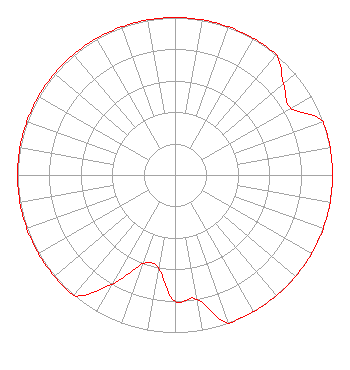 | ||||||||||||||||||
| Azimuth | Ratio | Azimuth | Ratio | Azimuth | Ratio | Azimuth | Ratio | ||||||||||||
| 0 | 1.000 | 10 | 1.000 | 20 | 1.000 | 30 | 1.000 | ||||||||||||
| 40 | 1.000 | 50 | 0.900 | 60 | 0.850 | 70 | 1.000 | ||||||||||||
| 80 | 1.000 | 90 | 1.000 | 100 | 1.000 | 110 | 1.000 | ||||||||||||
| 120 | 1.000 | 130 | 1.000 | 140 | 1.000 | 150 | 1.000 | ||||||||||||
| 160 | 1.000 | 170 | 0.800 | 180 | 0.800 | 190 | 0.600 | ||||||||||||
| 200 | 0.600 | 210 | 0.800 | 220 | 1.000 | 230 | 1.000 | ||||||||||||
| 240 | 1.000 | 250 | 1.000 | 260 | 1.000 | 270 | 1.000 | ||||||||||||
| 280 | 1.000 | 290 | 1.000 | 300 | 1.000 | 310 | 1.000 | ||||||||||||
| 320 | 1.000 | 330 | 1.000 | 340 | 1.000 | 350 | 1.000 | ||||||||||||
Structure Registration Number 1034136 Structure Type: TOWER Registered To: Saga Communications of New Hampshire, LLC Structure Address: Atop West Hill Keene, NH County Name: Cheshire County ASR Issued: 10/20/2009 Date Built: 04/01/1995 Site Elevation: 401.7 m (1318 ft.) Structure Height: 34.4 m (113 ft.) Height Overall: 34.4 m (113 ft.) Overall Height AMSL: 436.1 m (1431 ft.) FAA Determination: 10/18/2009 FAA Study #: 2009-ANE-1037-OE Paint & Light FAA Chapters: NONE PRIOR STUDY 2008-ANE-1298-OE 42-54-57.0 N 72-19-50.9 W (NAD 83) 42-54-56.7 N 72-19-52.6 W (Converted to NAD 27) |
73 Kercheval Avenue Grosse Pointe Farms, MI 48236 Phone: 313-886-7070 | Date: 11/30/2018 Application Certifier SAGA COMMUNICATIONS OF NEW HAMPSHIRE, LLC 73 Kercheval Avenue Grosse Pointe Farms, MI 48236 Applicant JUSTIN ASHER Asher Broadcast Consulting, Llc 579 Babcock Road Bronson, MI 49028-9347 TECHNICAL CONSULTANT GARY S. SMITHWICK, ESQ. Smithwick & Belendiuk, P.c. 5028 Wisconsin Avenue, Nw Suite 301 Washington, DC 20016 | |||||||||||||||||