
FCCInfo.com
A Service of Cavell, Mertz & Associates, Inc.
(855) FCC-INFO
|
|
W293DB from 07/20/2016 W293DB from 06/21/2007 W293DB from 06/24/2004 |
|
|
||||||||||||||||
|
|
W293DB Channel: 293D 106.5 MHz Champaign, Illinois Service: FX - A translator or application for a translator. Facility ID: 148907 Fac. Service: FX Programming Delivery Method: Unspecified Status: License Application Accepted: 09/11/2017 Application Granted: 09/13/2017 File Number: BLFT-20170911AAF License Expires: 00/00/0000 Prefix Type: This is a license for a translator Application Type: License To Cover FCC Website Links: LMS Facility Details This Application CDBS Application Other W293DB Applications Other W293DB Applications in CDBS Including Superseded Applications Mailing Address Correspondence for W293DB Correspondence related to application BLFT-20170911AAF Service Contour - Open Street Map or USGS Map (60 dBu) Service Contour - KML / Google Earth (60 dBu) Class: D, A Noncommercial educational operating with no more than 10W Site Location: 40-10-52.1 N 88-19-03.2 W (NAD 83) Site Location: 40-10-52.0 N 88-19-03.0 W (Converted to NAD 27) Effective Radiated Power: 0.25 kW Transmitter Output Power: 0.576 kW Antenna Center HAAT: 0 m Antenna Center AMSL: 368 m (1207 ft.) Antenna Center HAG: 107 m (351 ft.) Site Elevation: 261 m. (856 ft.) Height Overall*: 143 m (469 ft.) (* As Filed In This Application, may differ from ASR Data, Below.) Directional Antenna Antenna Make/Model: None Antenna ID: 127669 Polarization:
| ||||||||||||||||||
| Antenna Data for Antenna Id: 127669 W293DB FX File: BLFT-20170911AAF None - Service: FX | 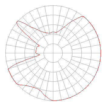 | ||||||||||||||||||
| Azimuth | Ratio | Azimuth | Ratio | Azimuth | Ratio | Azimuth | Ratio | ||||||||||||
| 0 | 0.442 | 10 | 0.442 | 20 | 0.537 | 30 | 0.749 | ||||||||||||
| 40 | 1.000 | 50 | 1.000 | 60 | 1.000 | 70 | 1.000 | ||||||||||||
| 80 | 1.000 | 90 | 1.000 | 100 | 1.000 | 110 | 1.000 | ||||||||||||
| 120 | 1.000 | 130 | 1.000 | 140 | 1.000 | 150 | 1.000 | ||||||||||||
| 160 | 1.000 | 170 | 1.000 | 180 | 1.000 | 190 | 0.915 | ||||||||||||
| 200 | 0.827 | 210 | 0.830 | 220 | 0.889 | 230 | 1.000 | ||||||||||||
| 240 | 1.000 | 250 | 1.000 | 260 | 0.330 | 270 | 0.360 | ||||||||||||
| 280 | 0.360 | 290 | 0.360 | 300 | 0.390 | 310 | 1.000 | ||||||||||||
| 320 | 0.712 | 330 | 0.534 | 340 | 0.456 | 350 | 0.423 | ||||||||||||
Structure Registration Number 1003972 Structure Type: GTOWER Registered To: American Towers LLC Structure Address: 4307 Goldfinch Rd (204196) Champaign, IL County Name: Champaign County ASR Issued: 04/04/2018 Date Built: 12/27/1994 Site Elevation: 260.6 m (855 ft.) Structure Height: 137.1 m (450 ft.) Height Overall: 143.3 m (470 ft.) Overall Height AMSL: 403.9 m (1325 ft.) FAA Determination: 04/03/2018 FAA Study #: 2018-AGL-5841-OE FAA Circular #: 70/7460-1L Paint & Light FAA Chapters: 4, 8, 12 PRIOR STUDY 1997-AGL-4829-OE 40-10-52.1 N 88-19-03.2 W (NAD 83) 40-10-52.0 N 88-19-03.0 W (Converted to NAD 27) |
1655 Ravine Lane Unit A Carpentersville, IL 60110 Phone: 847-687-9046 | Date: 09/11/2017 Application Certifier EDGEWATER BROADCASTING, INC. 160 W Gooding Street Twin Falls, ID 83301 Applicant GENE WISNIEWSKI 160 Gooding Street West Suite A Twin Falls, ID 83301 CONSULTING ENGINEER CLARK PARRISH Edgewater Broadcasting, Inc. 160 W Gooding Street Twin Falls, ID 83301 | |||||||||||||||||