
FCCInfo.com
A Service of Cavell, Mertz & Associates, Inc.
(855) FCC-INFO
|
|
W292CO from 04/17/2012 W292CO from 03/22/2004 |
|
|
||||||||||||||||
|
|
W292CO Channel: 292D 106.3 MHz Middletown, Ohio Service: FX - A translator or application for a translator. Facility ID: 138872 Fac. Service: FX Programming Delivery Method: Unspecified Status: License Application Accepted: 03/04/2013 Application Granted: 04/19/2013 File Number: BLFT-20130304ACM License Expires: 00/00/0000 Prefix Type: This is a license for a translator Application Type: License To Cover FCC Website Links: LMS Facility Details This Application CDBS Application Other W292CO Applications Other W292CO Applications in CDBS Including Superseded Applications Mailing Address Correspondence for W292CO Correspondence related to application BLFT-20130304ACM Service Contour - Open Street Map or USGS Map (60 dBu) Service Contour - KML / Google Earth (60 dBu) Class: D, A Noncommercial educational operating with no more than 10W Site Location: 39-16-24.0 N 84-31-37.0 W (NAD 83) Site Location: 39-16-23.8 N 84-31-37.2 W (Converted to NAD 27) Effective Radiated Power: 0 kW Horiz. ; 0.25 kW Vert. Transmitter Output Power: 0.193 kW Antenna Center HAAT: 203.1 m Horiz.; 0 m Vert. Antenna Center AMSL: 0 m Horiz.; 425 m Vert. Antenna Center HAG: 0 m Horiz.; 179 m Vert. Site Elevation: 246 m. (807 ft.) Height Overall*: 226 m (741 ft.) (* As Filed In This Application, may differ from ASR Data, Below.) Directional Antenna Antenna Make/Model: None Antenna ID: 111371 Polarization:
| ||||||||||||||||||
| Antenna Data for Antenna Id: 111371 W292CO FX File: BLFT-20130304ACM None - Service: FX | 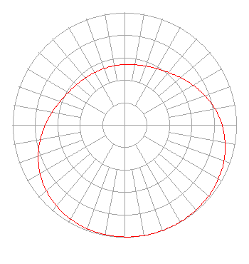 | ||||||||||||||||||
| Azimuth | Ratio | Azimuth | Ratio | Azimuth | Ratio | Azimuth | Ratio | ||||||||||||
| 0 | 0.537 | 10 | 0.544 | 20 | 0.556 | 30 | 0.578 | ||||||||||||
| 40 | 0.610 | 50 | 0.654 | 60 | 0.706 | 70 | 0.763 | ||||||||||||
| 80 | 0.819 | 90 | 0.870 | 100 | 0.911 | 110 | 0.944 | ||||||||||||
| 120 | 0.967 | 130 | 0.982 | 140 | 0.991 | 150 | 0.997 | ||||||||||||
| 160 | 1.000 | 170 | 1.000 | 180 | 0.997 | 190 | 0.991 | ||||||||||||
| 200 | 0.982 | 210 | 0.967 | 220 | 0.944 | 230 | 0.911 | ||||||||||||
| 240 | 0.870 | 250 | 0.819 | 260 | 0.763 | 270 | 0.706 | ||||||||||||
| 280 | 0.654 | 290 | 0.610 | 300 | 0.578 | 310 | 0.556 | ||||||||||||
| 320 | 0.544 | 330 | 0.537 | 340 | 0.534 | 350 | 0.534 | ||||||||||||
Structure Registration Number 1013596 Structure Type: TOWER Registered To: COMBINED TECHNOLOGIES INCORPORATED Structure Address: 1211 W Sharon Rd Cincinnati, OH County Name: Hamilton County ASR Issued: 03/25/1997 Date Built: 06/01/1983 Site Elevation: 245.7 m (806 ft.) Structure Height: 219.5 m (720 ft.) Height Overall: 225.6 m (740 ft.) Overall Height AMSL: 471.3 m (1546 ft.) FAA Determination: 04/04/1983 FAA Study #: 82-AGL-1268-OE FAA Circular #: 70/7460-1D Paint & Light FAA Chapters: 4, 7, 9 DUAL HIGH INTENSITY 39-16-24.0 N 84-31-37.0 W (NAD 83) 39-16-23.8 N 84-31-37.2 W (Converted to NAD 27) |
5700 West Oaks Blvd. Rocklin, CA 95765 Phone: 916-251-1732 | Date: 03/04/2013 Application Certifier EDUCATIONAL MEDIA FOUNDATION 5700 West Oaks Blvd Rocklin, CA 95765 Applicant SAM WALLINGTON 5700 West Oaks Blvd Rocklin, CA 95765 VP OF ENGINEERING DAVID OXENFORD, ESQ Wilkinson Barker Knauer, Llp 2300 N Street, N.w. Suite 700 Washington, DC 20037 | |||||||||||||||||