
FCCInfo.com
A Service of Cavell, Mertz & Associates, Inc.
(855) FCC-INFO
|
|
KMKL from 06/04/2001 |
|
|
||||||||||||||||
|
|
KMKL Channel: 212C3 90.3 MHz North Branch, Minnesota Service: FM - A full-service FM station or application. Facility ID: 121767 Fac. Service: FM Status: License Application Accepted: 03/12/2013 Application Granted: 03/29/2013 File Number: BLED-20130312AAR License Expires: 00/00/0000 Prefix Type: This is a license for a noncommercial educational FM station Application Type: License To Cover FCC Website Links: LMS Facility Details This Application CDBS Application Other KMKL Applications Other KMKL Applications in CDBS Including Superseded Applications Mailing Address Correspondence for KMKL Correspondence related to application BLED-20130312AAR Service Contour - Open Street Map or USGS Map (60 dBu) Service Contour - KML / Google Earth (60 dBu) Public Inspection Files Facility Type: NON-COMMERCIAL EDUC. FM Class: C3, A Zone II station; with 6kW-25kW ERP and a class contour distance 28km-39km Site Location: 45-32-40.9 N 92-58-20.8 W (NAD 83) Site Location: 45-32-41.0 N 92-58-20.0 W (Converted to NAD 27) Effective Radiated Power: 0 kW Horiz. ; 15 kW Vert. Transmitter Output Power: 1.945 kW Antenna Center HAAT: 0 m Horiz.; 123 m Vert. Antenna Center AMSL: 0 m Horiz.; 395 m Vert. Antenna Center HAG: 0 m Horiz.; 113 m Vert. Calculated Site Elevation: m. Height Overall*: 149 m (489 ft.) (* As Filed In This Application, may differ from ASR Data, Below.) Directional Antenna Antenna Make/Model: Electronics Research Inc. P300-4B-DA, 4 sections Antenna ID: 111807 Polarization:
| ||||||||||||||||||
| Antenna Data for Antenna Id: 111807 KMKL FM File: BLED-20130312AAR Electronics Research Inc. - P300-4B-DA, 4 sections Service: FM | 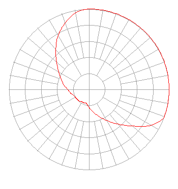 | ||||||||||||||||||
| Azimuth | Ratio | Azimuth | Ratio | Azimuth | Ratio | Azimuth | Ratio | ||||||||||||
| 0 | 1.000 | 10 | 1.000 | 20 | 1.000 | 30 | 1.000 | ||||||||||||
| 40 | 1.000 | 50 | 1.000 | 60 | 1.000 | 70 | 1.000 | ||||||||||||
| 80 | 1.000 | 90 | 1.000 | 100 | 1.000 | 110 | 1.000 | ||||||||||||
| 120 | 0.892 | 130 | 0.709 | 140 | 0.563 | 150 | 0.447 | ||||||||||||
| 160 | 0.355 | 170 | 0.282 | 180 | 0.224 | 190 | 0.178 | ||||||||||||
| 200 | 0.178 | 210 | 0.178 | 220 | 0.189 | 230 | 0.191 | ||||||||||||
| 240 | 0.197 | 250 | 0.208 | 260 | 0.238 | 270 | 0.266 | ||||||||||||
| 280 | 0.320 | 290 | 0.370 | 300 | 0.439 | 310 | 0.528 | ||||||||||||
| 320 | 0.645 | 330 | 0.772 | 340 | 0.875 | 350 | 0.967 | ||||||||||||
Structure Registration Number 1023116 [ASR Heights Differ from KMKL Application] Structure Type: TOWER Registered To: Cellco Partnership Structure Address: 0.3 Miles East On Cr 30 410th Street North Branch, MN County Name: Chisago County ASR Issued: 02/07/2020 Date Built: 10/07/2010 Site Elevation: 281.9 m (925 ft.) Structure Height: 147.8 m (485 ft.) Height Overall: 149.3 m (490 ft.) Overall Height AMSL: 431.2 m (1415 ft.) FAA Determination: 06/20/2010 FAA Study #: 2010-AGL-2346-OE FAA Circular #: 70/7460-1K Paint & Light FAA Chapters: 4, 8, 12 OM&L to remain the same as prior study = A MED-DUAL SYSTEM 45-32-40.8 N 92-58-20.4 W (NAD 83) 45-32-40.9 N 92-58-19.6 W (Converted to NAD 27) |
5700 West Oaks Blvd Rocklin, CA 95765 Phone: 916-251-1600 Not-for-Profit | Date: 03/12/2013 Application Certifier EDUCATIONAL MEDIA FOUNDATION 5700 West Oaks Blvd Rocklin, CA 95765 Applicant SAM WALLINGTON 5700 West Oaks Blvd Rocklin, CA 95765 VP OF ENGINEERING DAVID OXENFORD, ESQ Wilkinson Barker Knauer, Llp | |||||||||||||||||