
FCCInfo.com
A Service of Cavell, Mertz & Associates, Inc.
(855) FCC-INFO
|
|
K300DD from 01/28/2016 K300DD from 01/31/2014 K300DD from 08/25/1997 |
|
|
||||||||||||||||
|
|
K300DD Channel: 300D 107.9 MHz Watsonville, California Service: FX - A translator or application for a translator. Facility ID: 88248 Fac. Service: FX Programming Delivery Method: Unspecified Status: License Application Accepted: 05/05/2017 Application Granted: 05/11/2017 File Number: BLFT-20170505ADM License Expires: 00/00/0000 Prefix Type: This is a license for a translator Application Type: Amendment FCC Website Links: LMS Facility Details This Application CDBS Application Other K300DD Applications Other K300DD Applications in CDBS Including Superseded Applications Mailing Address Correspondence for K300DD Correspondence related to application BLFT-20170505ADM Service Contour - Open Street Map or USGS Map (60 dBu) Service Contour - KML / Google Earth (60 dBu) Class: D, A Noncommercial educational operating with no more than 10W Site Location: 37-03-27.8 N 121-46-33.8 W (NAD 83) Site Location: 37-03-28.0 N 121-46-30.0 W (Converted to NAD 27) Effective Radiated Power: 0 kW Horiz. ; 0.024 kW Vert. Transmitter Output Power: 0.006 kW Antenna Center HAAT: 0 m Antenna Center AMSL: 0 m Horiz.; 898 m Vert. Antenna Center HAG: 0 m Horiz.; 137 m Vert. Site Elevation: 761 m. (2497 ft.) Height Overall*: 473 m (1552 ft.) (* As Filed In This Application, may differ from ASR Data, Below.) Directional Antenna Antenna Make/Model: None Antenna ID: 126121 Polarization:
| ||||||||||||||||||
| Antenna Data for Antenna Id: 126121 K300DD FX File: BLFT-20170505ADM None - Service: FX Pattern and Field Values Include a 35° Clockwise Rotation | 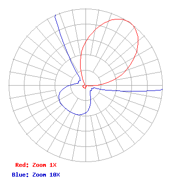 | ||||||||||||||||||
| Azimuth | Ratio | Azimuth | Ratio | Azimuth | Ratio | Azimuth | Ratio | ||||||||||||
| 5 | 0.645 | 15 | 0.820 | 25 | 0.950 | 35 | 1.000 | ||||||||||||
| 45 | 0.950 | 55 | 0.820 | 65 | 0.645 | 75 | 0.470 | ||||||||||||
| 85 | 0.250 | 95 | 0.085 | 105 | 0.020 | 115 | 0.010 | ||||||||||||
| 125 | 0.010 | 135 | 0.010 | 145 | 0.010 | 155 | 0.015 | ||||||||||||
| 165 | 0.025 | 175 | 0.034 | 185 | 0.038 | 195 | 0.040 | ||||||||||||
| 205 | 0.040 | 215 | 0.040 | 225 | 0.040 | 235 | 0.040 | ||||||||||||
| 245 | 0.038 | 255 | 0.034 | 265 | 0.025 | 275 | 0.015 | ||||||||||||
| 285 | 0.010 | 295 | 0.010 | 305 | 0.010 | 315 | 0.010 | ||||||||||||
| 325 | 0.020 | 335 | 0.085 | 345 | 0.250 | 355 | 0.470 | ||||||||||||
Structure Registration Number 1018359 Structure Type: TOWER Registered To: Mount Madonna Tower Owners Association Structure Address: Approx 9 Mi N Watsonville, CA County Name: Santa Clara County ASR Issued: 06/29/2009 Date Built: 01/01/1984 Site Elevation: 761.1 m (2497 ft.) Structure Height: 449.3 m (1474 ft.) Height Overall: 473.1 m (1552 ft.) Overall Height AMSL: 1234.2 m (4049 ft.) FAA Determination: 03/25/1997 FAA Study #: 97-AWP-0690-OE Paint & Light FAA Chapters: A1, B, F, H, 3, 10, 19, 21, 23 DUAL HIGH INTENSITY LIGHTS. 37-03-28.0 N 121-46-34.0 W (NAD 83) 37-03-28.2 N 121-46-30.2 W (Converted to NAD 27) |
2300 Portola Drive Santa Cruz, CA 95062 Phone: 831-477-1999 | Date: 05/05/2017 Application Certifier ZWERLING BROADCASTING SYSTEM LTD 2300 Portola Drive Santa Cruz, CA 95062 Applicant CHRIS COMPTON 44008 Hoban Ave Lancaster, CA 93534-4210 CONSULTING ENGINEER CARY S. TEPPER, ESQ. Tepper Law Firm, Llc 4900 Auburn Avenue Suite 100 Bethesda, MD 20814-2632 | |||||||||||||||||