
FCCInfo.com
A Service of Cavell, Mertz & Associates, Inc.
(855) FCC-INFO
|
|
WZFT from 05/29/2008 WZFT from 09/05/2003 WZFT from 10/10/2002 WZFT from 11/01/1994 WZFT from 02/01/1994 WZFT from 02/20/1993 |
|
|
||||||||||||||||
|
|
WZFT Channel: 282B 104.3 MHz Baltimore, Maryland Service: FS - A full service FM station auxiliary transmitting antenna or application. Facility ID: 8684 Fac. Service: FM Analog & Digital Status: License Application Accepted: 01/22/2010 Application Granted: 01/29/2010 File Number: BXLH-20100122ABA License Expires: 00/00/0000 Prefix Type: This is BXLH Application Type: License To Cover FCC Website Links: LMS Facility Details This Application CDBS Application Other WZFT Applications Other WZFT Applications in CDBS Including Superseded Applications Mailing Address Correspondence for WZFT Correspondence related to application BXLH-20100122ABA Service Contour - Open Street Map or USGS Map (54 dBu) Service Contour - KML / Google Earth (54 dBu) Public Inspection Files History Cards for WZFT Facility Type: FM STATION Class: B, A Zone I or I-A station; with 25kW-50kW ERP and a class contour distance 39km-52km Site Location: 39-25-45.4 N 76-26-59.9 W (NAD 83) Site Location: 39-25-45.0 N 76-27-01.0 W (Converted to NAD 27) Effective Radiated Power: 29 kW Transmitter Output Power: 14.32 kW Antenna Center HAAT: 145 m (476 ft.) Antenna Center AMSL: 221 m (725 ft.) Antenna Center HAG: 147 m (482 ft.) Calculated Site Elevation: 74 m. (243 ft.) Height Overall*: 153 m (502 ft.) (* As Filed In This Application, may differ from ASR Data, Below.) Directional Antenna Antenna Make/Model: Electronics Research Inc. FMH-4AE-DA-HW,4 sections, .5 wavelength spacing Antenna ID: 94083 Polarization: | ||||||||||||||||||
| Antenna Data for Antenna Id: 94083 WZFT FS File: BXLH-20100122ABA Electronics Research Inc. - FMH-4AE-DA-HW,4 sections, .5 wavelength spacing Service: FS | 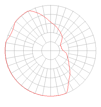 | ||||||||||||||||||
| Azimuth | Ratio | Azimuth | Ratio | Azimuth | Ratio | Azimuth | Ratio | ||||||||||||
| 0 | 0.630 | 10 | 0.562 | 20 | 0.501 | 30 | 0.446 | ||||||||||||
| 40 | 0.398 | 50 | 0.316 | 60 | 0.251 | 70 | 0.251 | ||||||||||||
| 80 | 0.251 | 90 | 0.281 | 100 | 0.354 | 110 | 0.396 | ||||||||||||
| 120 | 0.456 | 130 | 0.536 | 140 | 0.668 | 150 | 0.794 | ||||||||||||
| 160 | 1.000 | 170 | 1.000 | 180 | 1.000 | 190 | 1.000 | ||||||||||||
| 200 | 1.000 | 210 | 1.000 | 220 | 1.000 | 230 | 1.000 | ||||||||||||
| 240 | 1.000 | 250 | 1.000 | 260 | 1.000 | 270 | 1.000 | ||||||||||||
| 280 | 1.000 | 290 | 0.950 | 300 | 0.950 | 310 | 1.000 | ||||||||||||
| 320 | 1.000 | 330 | 1.000 | 340 | 0.891 | 350 | 0.749 | ||||||||||||
Structure Registration Number 1027387 Structure Type: GTOWER Registered To: American Towers LLC Structure Address: 4009 Miller Road (002008) Kingsville, MD County Name: Baltimore County ASR Issued: 12/14/2023 Date Built: 03/02/2004 Site Elevation: 73.8 m (242 ft.) Structure Height: 152.4 m (500 ft.) Height Overall: 153 m (502 ft.) Overall Height AMSL: 226.8 m (744 ft.) FAA Determination: 01/23/2023 FAA Study #: 2022-AEA-5850-OE FAA Circular #: 70/7460-1L Paint & Light FAA Chapters: 4, 8, 12 OM&L to remain the same as prior studies = A MED-DUAL SYSTEM 39-25-45.2 N 76-27-00.2 W (NAD 83) 39-25-44.8 N 76-27-01.3 W (Converted to NAD 27) |
7136 S. Yale Avenue Suite 501 Tulsa, OK 74136 Phone: 918-664-4581 | Date: 01/22/2010 Application Certifier CITICASTERS LICENSES, INC. 7136 S. Yale Avenue Suite 501 Tulsa, OK 74136-2623 Applicant TROY G. LANGHAM Clear Channel TROY G. LANGHAM 2625 S. Memorial Dr Suite A Tulsa, OK 74126-2623 FCC ENGINEERING SUPERVISOR | |||||||||||||||||