
FCCInfo.com
A Service of Cavell, Mertz & Associates, Inc.
(855) FCC-INFO
|
|
|
|  |
|
|||||||||||||||
|
|
KCCU Channel: 207C3 89.3 MHz Lawton, Oklahoma Service: FM - A full-service FM station or application. Facility ID: 8484 Fac. Service: FM Analog & Digital Status: License Application Accepted: 02/20/2013 Application Granted: 02/28/2013 File Number: BLED-20130220ABD License Expires: 00/00/0000 Prefix Type: This is a license for a noncommercial educational FM station Application Type: License To Cover FCC Website Links: LMS Facility Details This Application CDBS Application Other KCCU Applications Other KCCU Applications in CDBS Including Superseded Applications Mailing Address Correspondence for KCCU Correspondence related to application BLED-20130220ABD Service Contour - Open Street Map or USGS Map (60 dBu) Service Contour - KML / Google Earth (60 dBu) Public Inspection Files Facility Type: NON-COMMERCIAL EDUC. FM Class: C3, A Zone II station; with 6kW-25kW ERP and a class contour distance 28km-39km Site Location: 34-37-24.3 N 98-16-17.2 W (NAD 83) Site Location: 34-37-24.0 N 98-16-16.0 W (Converted to NAD 27) Effective Radiated Power: 5 kW Transmitter Output Power: 2.22 kW Antenna Center HAAT: 141 m (463 ft.) Antenna Center AMSL: 486 m (1594 ft.) Antenna Center HAG: 90 m (295 ft.) Calculated Site Elevation: 396 m. (1299 ft.) Height Overall*: 107 m (351 ft.) (* As Filed In This Application, may differ from ASR Data, Below.) Directional Antenna Antenna Make/Model: Electronics Research Inc. LP-3E-DA, three sections Antenna ID: 108336 Polarization:
| ||||||||||||||||||
| Antenna Data for Antenna Id: 108336 KCCU FM File: BLED-20130220ABD Electronics Research Inc. - LP-3E-DA, three sections Service: FM | 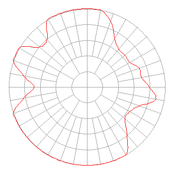 | ||||||||||||||||||
| Azimuth | Ratio | Azimuth | Ratio | Azimuth | Ratio | Azimuth | Ratio | ||||||||||||
| 0 | 1.000 | 10 | 1.000 | 20 | 0.890 | 30 | 0.708 | ||||||||||||
| 40 | 0.631 | 50 | 0.631 | 60 | 0.631 | 70 | 0.708 | ||||||||||||
| 80 | 0.708 | 90 | 0.794 | 100 | 0.890 | 110 | 0.708 | ||||||||||||
| 120 | 0.631 | 130 | 0.631 | 140 | 0.794 | 150 | 1.000 | ||||||||||||
| 160 | 1.000 | 170 | 1.000 | 180 | 1.000 | 190 | 1.000 | ||||||||||||
| 200 | 1.000 | 210 | 1.000 | 220 | 1.000 | 230 | 1.000 | ||||||||||||
| 240 | 1.000 | 250 | 1.000 | 260 | 0.822 | 270 | 0.677 | ||||||||||||
| 280 | 0.822 | 290 | 1.000 | 300 | 1.000 | 310 | 0.794 | ||||||||||||
| 320 | 0.794 | 330 | 1.000 | 340 | 1.000 | 350 | 1.000 | ||||||||||||
Structure Registration Number 1204648 Structure Type: TOWER Registered To: Oklahoma State Regents for Higher Ed Structure Address: 8 Mi East Of Lawton, OK County Name: Comanche County ASR Issued: 07/20/2010 Date Built: 05/03/2008 Site Elevation: 396.2 m (1300 ft.) Structure Height: 107.3 m (352 ft.) Height Overall: 107.3 m (352 ft.) Overall Height AMSL: 503.5 m (1652 ft.) FAA Determination: 12/22/2007 FAA Study #: 2007-ASW-11419-OE FAA Circular #: 70/7460-1K Paint & Light FAA Chapters: 4, 8, 12 34-37-24.2 N 98-16-17.1 W (NAD 83) 34-37-23.9 N 98-16-15.9 W (Converted to NAD 27) |
2800 West Gore Lawton, OK 73505 Phone: 580-581-2472 Fax: 580-581-5571 Private Not-for-Profit Educational Institution | Date: 02/20/2013 Application Certifier CAMERON UNIVERSITY 2800 West Gore Lawton, OK 73505 Applicant CARY S. TEPPER, ESQ. Booth, Freret, Imlay & Tepper, P.c. LAURA M. MIZRAHI Communications Technologies, Inc. P. O. Box 1130 Marlton, NJ 08053 TECHNICAL CONSULTANT | |||||||||||||||||
|
| ||||||||||||||||||