
FCCInfo.com
A Service of Cavell, Mertz & Associates, Inc.
(855) FCC-INFO
|
|
W277DE from 04/26/2013 |
|
|
||||||||||||||||
|
|
W277DE Channel: 277D 103.3 MHz Fleming Island, Florida Service: FX - A translator or application for a translator. Facility ID: 142664 Fac. Service: FX Programming Delivery Method: Unspecified Status: License Application Accepted: 12/30/2016 Application Granted: 04/05/2017 File Number: BLFT-20161230AAX License Expires: 00/00/0000 Prefix Type: This is a license for a translator Application Type: License To Cover FCC Website Links: LMS Facility Details This Application CDBS Application Other W277DE Applications Other W277DE Applications in CDBS Including Superseded Applications Mailing Address Correspondence for W277DE Correspondence related to application BLFT-20161230AAX Service Contour - Open Street Map or USGS Map (60 dBu) Service Contour - KML / Google Earth (60 dBu) Class: D, A Noncommercial educational operating with no more than 10W Site Location: 30-04-23.9 N 81-47-26.4 W (NAD 83) Site Location: 30-04-23.0 N 81-47-27.0 W (Converted to NAD 27) Effective Radiated Power: 0.25 kW Transmitter Output Power: 1.01 kW Antenna Center HAAT: 0 m Antenna Center AMSL: 157 m (515 ft.) Antenna Center HAG: 150 m (492 ft.) Site Elevation: 7 m. (23 ft.) Height Overall*: 152 m (499 ft.) (* As Filed In This Application, may differ from ASR Data, Below.) Directional Antenna Antenna Make/Model: None Antenna ID: 126321 Polarization:
| ||||||||||||||||||
| Antenna Data for Antenna Id: 126321 W277DE FX File: BLFT-20161230AAX None - Service: FX Pattern and Field Values Include a 120° Clockwise Rotation | 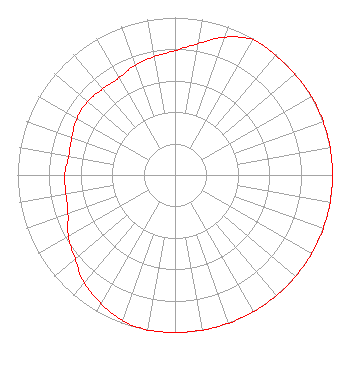 | ||||||||||||||||||
| Azimuth | Ratio | Azimuth | Ratio | Azimuth | Ratio | Azimuth | Ratio | ||||||||||||
| 0 | 0.789 | 10 | 0.847 | 20 | 0.932 | 30 | 0.991 | ||||||||||||
| 40 | 0.992 | 50 | 0.994 | 60 | 1.000 | 70 | 1.000 | ||||||||||||
| 80 | 1.000 | 90 | 1.000 | 100 | 1.000 | 110 | 1.000 | ||||||||||||
| 120 | 1.000 | 130 | 1.000 | 140 | 1.000 | 150 | 1.000 | ||||||||||||
| 160 | 1.000 | 170 | 1.000 | 180 | 1.000 | 190 | 1.000 | ||||||||||||
| 200 | 0.982 | 210 | 0.941 | 220 | 0.896 | 230 | 0.828 | ||||||||||||
| 240 | 0.782 | 250 | 0.723 | 260 | 0.703 | 270 | 0.700 | ||||||||||||
| 280 | 0.685 | 290 | 0.697 | 300 | 0.718 | 310 | 0.725 | ||||||||||||
| 320 | 0.713 | 330 | 0.712 | 340 | 0.740 | 350 | 0.763 | ||||||||||||
Structure Registration Number 1031135 Structure Type: 2TA2 Registered To: GOOD TIDINGS TRUST INC Structure Address: Twr 2 - 2500 Russell Rd Green Cove Springs, FL County Name: Clay County ASR Issued: 04/24/2012 Date Built: 10/01/1987 Site Elevation: 7 m (23 ft.) Structure Height: 151.2 m (496 ft.) Height Overall: 152.1 m (499 ft.) Overall Height AMSL: 159.1 m (522 ft.) FAA Determination: 04/23/2012 FAA Study #: 2012-ASO-2068-OE FAA Circular #: 70/7460-1K Paint & Light FAA Chapters: 3, 4, 5, 12 30-04-23.4 N 81-47-26.0 W (NAD 83) 30-04-22.5 N 81-47-26.6 W (Converted to NAD 27) |
2500 Russell Road Green Cove Springs, FL 32043 Phone: 904-284-1111 Corporation | Date: 12/30/2016 Application Certifier GOOD TIDINGS TRUST, INC. 2500 Russell Rd. Green Cove Springs, FL 32043 Applicant CHARLES KEILER 6711 Nw 26 Way Fort Lauderdale, FL 33309 CONSULTING ENGINEER BILL TIDWELL Good Tidings Trust, Inc. 2500 Russell Rd. Green Cove Springs, FL 32043 | |||||||||||||||||