
FCCInfo.com
A Service of Cavell, Mertz & Associates, Inc.
(855) FCC-INFO
|
|
WPOW from 10/22/1985 |
|  |
|
|||||||||||||||
|
|
WPOW Channel: 243C 96.5 MHz Miami, Florida Service: FS - A full service FM station auxiliary transmitting antenna or application. Facility ID: 73893 Fac. Service: FM Analog & Digital Status: License Application Accepted: 07/17/2015 Application Granted: 08/04/2015 File Number: BXLH-20150717AAG License Expires: 00/00/0000 Prefix Type: This is BXLH Application Type: License To Cover FCC Website Links: LMS Facility Details This Application CDBS Application Other WPOW Applications Other WPOW Applications in CDBS Including Superseded Applications Mailing Address Correspondence for WPOW Correspondence related to application BXLH-20150717AAG Service Contour - Open Street Map or USGS Map (60 dBu) Service Contour - KML / Google Earth (60 dBu) Public Inspection Files Facility Type: FM STATION Class: C, A Zone II station; with exactly 100kW ERP and a class contour distance 72km-92km Site Location: 25-58-08.3 N 80-13-19.2 W (NAD 83) Site Location: 25-58-07.0 N 80-13-20.0 W (Converted to NAD 27) Effective Radiated Power: 100 kW Transmitter Output Power: 15.7 kW Antenna Center HAAT: 302 m (991 ft.) Antenna Center AMSL: 302 m (991 ft.) Antenna Center HAG: 300 m (984 ft.) Calculated Site Elevation: 2 m. (7 ft.) Height Overall*: 317.3 m (1041 ft.) (* As Filed In This Application, may differ from ASR Data, Below.) Directional Antenna Antenna Make/Model: Electronics Research Inc. COG1184-8CP-2DA, 8 bays 0.8 wavelength spaced Antenna ID: 121792 Polarization: | ||||||||||||||||||
| Antenna Data for Antenna Id: 121792 WPOW FS File: BXLH-20150717AAG Electronics Research Inc. - COG1184-8CP-2DA, 8 bays 0.8 wavelength spaced Service: FS | 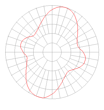 | ||||||||||||||||||
| Azimuth | Ratio | Azimuth | Ratio | Azimuth | Ratio | Azimuth | Ratio | ||||||||||||
| 0 | 0.904 | 10 | 0.978 | 20 | 0.988 | 30 | 0.933 | ||||||||||||
| 40 | 0.829 | 50 | 0.717 | 60 | 0.624 | 70 | 0.571 | ||||||||||||
| 80 | 0.574 | 90 | 0.662 | 100 | 0.724 | 110 | 0.724 | ||||||||||||
| 120 | 0.666 | 130 | 0.585 | 140 | 0.540 | 150 | 0.580 | ||||||||||||
| 160 | 0.662 | 170 | 0.778 | 180 | 0.900 | 190 | 0.990 | ||||||||||||
| 195 | 1.000 | 200 | 0.998 | 210 | 0.946 | 220 | 0.845 | ||||||||||||
| 230 | 0.727 | 240 | 0.630 | 250 | 0.571 | 260 | 0.549 | ||||||||||||
| 270 | 0.621 | 280 | 0.681 | 290 | 0.678 | 300 | 0.617 | ||||||||||||
| 310 | 0.531 | 320 | 0.538 | 330 | 0.585 | 340 | 0.673 | ||||||||||||
| 350 | 0.789 | ||||||||||||||||||
Structure Registration Number 1026553 [ASR Heights Differ from WPOW Application] Structure Type: GTOWER Registered To: American Towers LLC Structure Address: 1255 Nw 210th Street (282698) Miami, FL County Name: Miami-Dade County ASR Issued: 10/12/2023 Date Built: 01/01/1990 Site Elevation: 1.5 m (5 ft.) Structure Height: 289.9 m (951 ft.) Height Overall: 318.2 m (1044 ft.) Overall Height AMSL: 319.7 m (1049 ft.) FAA Determination: 04/21/2023 FAA Study #: 2022-ASO-14780-OE FAA Circular #: 70/7460-1G Paint & Light FAA Chapters: 4, 6, 9 OM&L to remain the same as prior study = 24-HR HI-STROBES 25-58-08.3 N 80-13-19.2 W (NAD 83) 25-58-07.0 N 80-13-20.0 W (Converted to NAD 27) |
2400 Market Street 4th Floor Philadelphia, PA 19103 Phone: 610-660-5610 Limited Liability Company | Date: 07/17/2015 Application Certifier CBS RADIO STATIONS INC. 1800 K St Nw Suite 920 Washington, DC 20006 Applicant BERT GOLDMAN 1511 Radcliffe Way Auburn, CA 95603 TECHNICAL CONSULTANT RAYMOND BENEDICT Cbs | |||||||||||||||||
| |||||||||||||||||||