
FCCInfo.com
A Service of Cavell, Mertz & Associates, Inc.
(855) FCC-INFO
|
|
|
|
|
||||||||||||||||
|
|
WKAQ-FM2 Channel: 284D 104.7 MHz Fajardo, Puerto Rico Service: FB - A booster station or application for a booster. Facility ID: 179635 Fac. Service: FB Programming Delivery Method: Unspecified Status: License Application Accepted: 10/15/2010 Application Granted: 11/02/2010 File Number: BLFTB-20101015AAU License Expires: 00/00/0000 Prefix Type: This is a license for a booster Application Type: License To Cover FCC Website Links: LMS Facility Details This Application CDBS Application Other WKAQ-FM2 Applications Other WKAQ-FM2 Applications in CDBS Including Superseded Applications Mailing Address Correspondence for WKAQ-FM2 Correspondence related to application BLFTB-20101015AAU Service Contour - Open Street Map or USGS Map (60 dBu) Service Contour - KML / Google Earth (60 dBu) Facility Type: FM STATION Class: D, A Noncommercial educational operating with no more than 10W Site Location: 18-16-52.0 N 65-40-09.0 W (NAD 83) Site Location: 18-16-59.2 N 65-40-10.4 W (Converted to NAD 27) Effective Radiated Power: 0.5 kW Transmitter Output Power: 0.106 kW Antenna Center HAAT: 0 m Antenna Center AMSL: 301 m (988 ft.) Antenna Center HAG: 18 m (59 ft.) Site Elevation: 283 m. (928 ft.) Height Overall*: 30 m (98 ft.) (* As Filed In This Application, may differ from ASR Data, Below.) Directional Antenna Antenna Make/Model: None Antenna ID: 101233 Polarization:
| ||||||||||||||||||
| Antenna Data for Antenna Id: 101233 WKAQ-FM2 FB File: BLFTB-20101015AAU None - Service: FB Pattern and Field Values Include a 60° Clockwise Rotation | 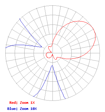 | ||||||||||||||||||
| Azimuth | Ratio | Azimuth | Ratio | Azimuth | Ratio | Azimuth | Ratio | ||||||||||||
| 0 | 0.203 | 10 | 0.363 | 20 | 0.553 | 30 | 0.727 | ||||||||||||
| 40 | 0.871 | 50 | 0.966 | 60 | 1.000 | 70 | 0.966 | ||||||||||||
| 80 | 0.871 | 90 | 0.727 | 100 | 0.553 | 110 | 0.363 | ||||||||||||
| 120 | 0.203 | 130 | 0.138 | 140 | 0.141 | 150 | 0.157 | ||||||||||||
| 160 | 0.130 | 170 | 0.060 | 180 | 0.027 | 190 | 0.042 | ||||||||||||
| 200 | 0.088 | 210 | 0.117 | 220 | 0.134 | 230 | 0.143 | ||||||||||||
| 240 | 0.145 | 250 | 0.143 | 260 | 0.134 | 270 | 0.117 | ||||||||||||
| 280 | 0.088 | 290 | 0.042 | 300 | 0.027 | 310 | 0.060 | ||||||||||||
| 320 | 0.130 | 330 | 0.157 | 340 | 0.141 | 350 | 0.138 | ||||||||||||
Structure Registration Number 1233151 Structure Type: TOWER Structure Address: 2.57 Kilometers Northwest Of Ceiba Ceiba, PR County Name: Ceiba Municipio ASR Issued: 03/25/2002 Site Elevation: 283 m (928 ft.) Structure Height: 30 m (98 ft.) Height Overall: 30 m (98 ft.) Overall Height AMSL: 313 m (1027 ft.) FAA Determination: 03/12/2002 FAA Study #: 02-ASO-0654-OE FAA Circular #: Paint & Light FAA Chapters: NONE PRIOR STUDY 97-ASO-0650-OE 18-16-44.8 N 65-40-07.6 W (NAD 83) 18-16-52.0 N 65-40-09.0 W (Converted to NAD 27) |
San Juan, PR 00936 Phone: 787-924-4444 General Partnership | Date: 10/15/2010 Application Certifier WLII/WSUR LICENSE PARTNERSHIP, GP 5999 Center Drive Suite 4083 Los Angeles, CA 90045 Applicant CHARLES W. STAPLES 4424 Glenwick Lane University Park, TX 75205-1037 TECHNICAL CONSULTANT WILLIAM H. FITZ, ESQ. Covington & Burling Llp 1201 Pennsylvania Avenue, Nw Washington, DC 20004 | |||||||||||||||||