
FCCInfo.com
A Service of Cavell, Mertz & Associates, Inc.
(855) FCC-INFO
|
|
|
|  |
|
|||||||||||||||
|
|
WRSM Channel: 206A 89.1 MHz Rising Sun, Maryland Service: FM - A full-service FM station or application. Facility ID: 173256 Fac. Service: FM Status: License Application Accepted: 03/28/2013 Application Granted: 03/29/2013 File Number: BLED-20130328AQA License Expires: 00/00/0000 Prefix Type: This is a license for a noncommercial educational FM station Application Type: License To Cover FCC Website Links: LMS Facility Details This Application CDBS Application Other WRSM Applications Other WRSM Applications in CDBS Including Superseded Applications Mailing Address Correspondence for WRSM Correspondence related to application BLED-20130328AQA Service Contour - Open Street Map or USGS Map (60 dBu) Service Contour - KML / Google Earth (60 dBu) Public Inspection Files Facility Type: NON-COMMERCIAL EDUC. FM Class: A, A Zone I; I-A; or II station; with 0.1kW-6kW ERP and a class contour distance <=28km Site Location: 39-43-17.4 N 76-09-17.8 W (NAD 83) Site Location: 39-43-17.0 N 76-09-19.0 W (Converted to NAD 27) Effective Radiated Power: 0.001 kW Horiz. ; 1 kW Vert. Transmitter Output Power: 0.47 kW Antenna Center HAAT: 96 m (315 ft.) Antenna Center AMSL: 196 m (643 ft.) Antenna Center HAG: 52 m (171 ft.) Calculated Site Elevation: 144 m. (472 ft.) Height Overall*: 64 m (210 ft.) (* As Filed In This Application, may differ from ASR Data, Below.) Directional Antenna Antenna Make/Model: Scala YA7-FML Antenna ID: 111848 Polarization:
| ||||||||||||||||||
| Antenna Data for Antenna Id: 111848 WRSM FM File: BLED-20130328AQA Scala - YA7-FML Service: FM | 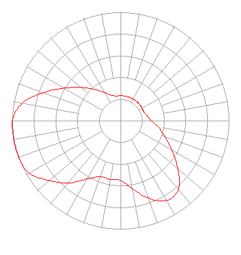 | ||||||||||||||||||
| Azimuth | Ratio | Azimuth | Ratio | Azimuth | Ratio | Azimuth | Ratio | ||||||||||||
| 0 | 0.230 | 10 | 0.230 | 20 | 0.230 | 30 | 0.230 | ||||||||||||
| 40 | 0.232 | 50 | 0.230 | 60 | 0.230 | 70 | 0.230 | ||||||||||||
| 80 | 0.250 | 90 | 0.283 | 100 | 0.356 | 110 | 0.435 | ||||||||||||
| 120 | 0.548 | 130 | 0.689 | 140 | 0.830 | 150 | 0.850 | ||||||||||||
| 160 | 0.763 | 170 | 0.637 | 180 | 0.550 | 190 | 0.550 | ||||||||||||
| 200 | 0.550 | 210 | 0.623 | 220 | 0.750 | 230 | 0.858 | ||||||||||||
| 240 | 0.970 | 250 | 1.000 | 260 | 1.000 | 270 | 1.000 | ||||||||||||
| 280 | 0.920 | 290 | 0.755 | 300 | 0.599 | 310 | 0.476 | ||||||||||||
| 320 | 0.378 | 330 | 0.300 | 340 | 0.250 | 350 | 0.230 | ||||||||||||
Structure Registration Number 1037350 [ASR Heights Differ from WRSM Application] Structure Type: TOWER Registered To: CNS Microwave, LLC Structure Address: .48 Mi Ne Rock Springs, MD County Name: Cecil County ASR Issued: 11/03/2021 Date Built: 01/01/1963 Site Elevation: 143.5 m (471 ft.) Structure Height: 64 m (210 ft.) Height Overall: 64 m (210 ft.) Overall Height AMSL: 207.5 m (681 ft.) FAA Determination: 08/19/1963 FAA Study #: 1-OE-3768 Paint & Light FAA Chapters: 1, 3, 11, 21 RED LIGHTS/PAINT 39-43-17.0 N 76-09-18.0 W (NAD 83) 39-43-16.6 N 76-09-19.2 W (Converted to NAD 27) |
55 East Main Street Marlton, NJ 08053 Phone: 856-983-1662 Not-for-Profit | Date: 03/28/2013 Application Certifier HOPE CHRISTIAN CHURCH OF MARLTON, INC. 55 East Main Street Marlton, NJ 08053 Applicant HARRY C. MARTIN, ESQUIRE Fletcher, Heald & Hildreth, Plc WILLIAM C. LUEBKEMANN, JR. 55 East Main Street Marlton, NJ 08053 PRESIDENT/CHIEF ENGINEER | |||||||||||||||||