
FCCInfo.com
A Service of Cavell, Mertz & Associates, Inc.
(855) FCC-INFO
|
|
W252DG from 12/06/2013 |
|
|
||||||||||||||||
|
|
W252DG Channel: 252D 98.3 MHz Grand Rapids, Michigan Service: FX - A translator or application for a translator. Facility ID: 151670 Fac. Service: FX Programming Delivery Method: Unspecified Status: License Application Accepted: 07/17/2018 Application Granted: 08/08/2018 File Number: BMLFT-20180717ABJ License Expires: 00/00/0000 Prefix Type: This is a modification of license for a translator Application Type: Minor Modification FCC Website Links: LMS Facility Details This Application CDBS Application Other W252DG Applications Other W252DG Applications in CDBS Including Superseded Applications Mailing Address Correspondence for W252DG Correspondence related to application BMLFT-20180717ABJ Service Contour - Open Street Map or USGS Map (60 dBu) Service Contour - KML / Google Earth (60 dBu) Class: D, A Noncommercial educational operating with no more than 10W Site Location: 42-57-25.1 N 85-54-07.1 W (NAD 83) Site Location: 42-57-25.0 N 85-54-07.0 W (Converted to NAD 27) Effective Radiated Power: 0.25 kW Transmitter Output Power: 0.123 kW Antenna Center HAAT: 0 m Antenna Center AMSL: 481 m Horiz.; 0 m Vert. Antenna Center HAG: 274 m Horiz.; 0 m Vert. Site Elevation: 207 m. (679 ft.) Height Overall*: 301 m (988 ft.) (* As Filed In This Application, may differ from ASR Data, Below.) Directional Antenna Antenna Make/Model: None Antenna ID: 123555 Polarization:
| ||||||||||||||||||
| Antenna Data for Antenna Id: 123555 W252DG FX File: BMLFT-20180717ABJ None - Service: FX Pattern and Field Values Include a 89° Clockwise Rotation | 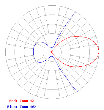 | ||||||||||||||||||
| Azimuth | Ratio | Azimuth | Ratio | Azimuth | Ratio | Azimuth | Ratio | ||||||||||||
| 9 | 0.010 | 19 | 0.020 | 29 | 0.085 | 39 | 0.250 | ||||||||||||
| 49 | 0.470 | 59 | 0.645 | 69 | 0.820 | 79 | 0.950 | ||||||||||||
| 89 | 1.000 | 99 | 0.950 | 109 | 0.820 | 119 | 0.645 | ||||||||||||
| 129 | 0.470 | 139 | 0.250 | 149 | 0.085 | 159 | 0.020 | ||||||||||||
| 169 | 0.010 | 179 | 0.010 | 189 | 0.010 | 199 | 0.010 | ||||||||||||
| 209 | 0.015 | 219 | 0.025 | 229 | 0.034 | 239 | 0.038 | ||||||||||||
| 249 | 0.040 | 259 | 0.040 | 269 | 0.040 | 279 | 0.040 | ||||||||||||
| 289 | 0.040 | 299 | 0.038 | 309 | 0.034 | 319 | 0.025 | ||||||||||||
| 329 | 0.015 | 339 | 0.010 | 349 | 0.010 | 359 | 0.010 | ||||||||||||
Structure Registration Number 1002079 Structure Type: Registered To: TRI-STATE CHRISTIAN TV, INC. Structure Address: 10290 48th Ave Allendale, MI County Name: Ottawa County ASR Issued: 06/10/2021 Date Built: 01/01/1986 Site Elevation: 207.2 m (680 ft.) Structure Height: 285.6 m (937 ft.) Height Overall: 301.1 m (988 ft.) Overall Height AMSL: 508.3 m (1668 ft.) FAA Determination: 10/04/1983 FAA Study #: 83-AGL-990-OE Paint & Light FAA Chapters: A1, B, D, H DUAL HIGH INTENSITY 42-57-25.0 N 85-54-07.0 W (NAD 83) 42-57-24.9 N 85-54-06.9 W (Converted to NAD 27) |
2504 Ardmore Street, S.e. Grand Rapids, MI 49506 Phone: 616-956-1140 | Date: 07/17/2018 Application Certifier HOLY FAMILY RADIO, INC. 2504 Ardmore Street, Se Grand Rapids, MI 49506 Applicant MARK A. MUELLER Mueller Broadcast Design 613 S. La Grange Rd. La Grange, IL 60525-5601 TECHNICAL CONSULTANT DENNIS J. KELLY Law Office Of Dennis J. Kelly Post Office Box 41177 Washington, DC 20018-0577 | |||||||||||||||||