
FCCInfo.com
A Service of Cavell, Mertz & Associates, Inc.
(855) FCC-INFO
|
|
|
|
|
||||||||||||||||
|
|
W258DM Channel: 258D 99.5 MHz Greeneville, Tennessee Service: FX - A translator or application for a translator. Facility ID: 202061 Fac. Service: FX Programming Delivery Method: Unspecified Status: License Application Accepted: 07/11/2018 Application Granted: 08/27/2018 File Number: BLFT-20180711AAF License Expires: 00/00/0000 Prefix Type: This is a license for a translator Application Type: License To Cover FCC Website Links: LMS Facility Details This Application CDBS Application Other W258DM Applications Other W258DM Applications in CDBS Including Superseded Applications Mailing Address Correspondence for W258DM Correspondence related to application BLFT-20180711AAF Service Contour - Open Street Map or USGS Map (60 dBu) Service Contour - KML / Google Earth (60 dBu) Class: D, A Noncommercial educational operating with no more than 10W Site Location: 36-10-10.4 N 82-50-51.6 W (NAD 83) Site Location: 36-10-10.0 N 82-50-52.0 W (Converted to NAD 27) Effective Radiated Power: 0.25 kW Transmitter Output Power: 0.231 kW Antenna Center HAAT: 0 m Antenna Center AMSL: 525 m (1722 ft.) Antenna Center HAG: 85 m (279 ft.) Site Elevation: 440 m. (1444 ft.) Height Overall*: 92 m (302 ft.) (* As Filed In This Application, may differ from ASR Data, Below.) Directional Antenna Antenna Make/Model: None Antenna ID: 132217 Polarization:
| ||||||||||||||||||
| Antenna Data for Antenna Id: 132217 W258DM FX File: BLFT-20180711AAF None - Service: FX | 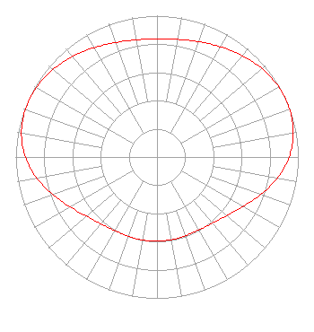 | ||||||||||||||||||
| Azimuth | Ratio | Azimuth | Ratio | Azimuth | Ratio | Azimuth | Ratio | ||||||||||||
| 0 | 0.837 | 10 | 0.845 | 20 | 0.868 | 30 | 0.901 | ||||||||||||
| 40 | 0.936 | 50 | 0.972 | 60 | 0.994 | 70 | 0.999 | ||||||||||||
| 80 | 0.979 | 90 | 0.935 | 100 | 0.864 | 110 | 0.779 | ||||||||||||
| 120 | 0.702 | 130 | 0.645 | 140 | 0.611 | 150 | 0.596 | ||||||||||||
| 160 | 0.592 | 170 | 0.594 | 180 | 0.596 | 190 | 0.596 | ||||||||||||
| 200 | 0.596 | 210 | 0.601 | 220 | 0.617 | 230 | 0.651 | ||||||||||||
| 240 | 0.707 | 250 | 0.781 | 260 | 0.864 | 270 | 0.932 | ||||||||||||
| 280 | 0.974 | 290 | 0.991 | 300 | 0.985 | 310 | 0.962 | ||||||||||||
| 320 | 0.929 | 330 | 0.893 | 340 | 0.862 | 350 | 0.842 | ||||||||||||
Structure Registration Number 1043091 Structure Type: TOWER Registered To: RADIO GREENEVILLE INC Structure Address: 1004 Arnold Rd Greeneville, TN County Name: Greene County ASR Issued: 04/07/1998 Date Built: 11/22/1976 Site Elevation: 440 m (1444 ft.) Structure Height: 92 m (302 ft.) Height Overall: 92.4 m (303 ft.) Overall Height AMSL: 532.4 m (1747 ft.) FAA Determination: 12/07/1976 FAA Study #: 75-SO-724-OE Paint & Light FAA Chapters: 1, 3, 12, 21 RED LIGHTS/PAINT 36-10-10.0 N 82-50-52.0 W (NAD 83) 36-10-09.6 N 82-50-52.4 W (Converted to NAD 27) |
Po Box 278 Greeneville, TN 37744 Phone: 423-638-4147 | Date: 07/11/2018 Application Certifier RADIO GREENEVILLE, INC. Po Box 278 Greeneville, TN 37744 Applicant CHARLES M. ANDERSON 1519 Euclid Avenue Bowling Green, KY 42103 ENGINEERING CONSULTANT PAUL R. METCALFE Radio Greeneville, Inc. Po Box 278 Greeneville, TN 37744 | |||||||||||||||||