
FCCInfo.com
A Service of Cavell, Mertz & Associates, Inc.
(855) FCC-INFO
|
|
W225CJ from 12/11/2013 |
|
|
||||||||||||||||
|
|
W225CJ Channel: 225D 92.9 MHz Asheville, North Carolina Service: FX - A translator or application for a translator. Facility ID: 141057 Fac. Service: FX Programming Delivery Method: Unspecified Status: License Application Accepted: 05/25/2017 Application Granted: 06/06/2017 File Number: BLFT-20170525AMP License Expires: 00/00/0000 Prefix Type: This is a license for a translator Application Type: License To Cover FCC Website Links: LMS Facility Details This Application CDBS Application Other W225CJ Applications Other W225CJ Applications in CDBS Including Superseded Applications Mailing Address Correspondence for W225CJ Correspondence related to application BLFT-20170525AMP Service Contour - Open Street Map or USGS Map (60 dBu) Service Contour - KML / Google Earth (60 dBu) Class: D, A Noncommercial educational operating with no more than 10W Site Location: 35-35-50.8 N 82-36-20.0 W (NAD 83) Site Location: 35-35-50.4 N 82-36-20.5 W (Converted to NAD 27) Effective Radiated Power: 0 kW Horiz. ; 0.18 kW Vert. Transmitter Output Power: 0.155 kW Antenna Center HAAT: 0 m Antenna Center AMSL: 0 m Horiz.; 755 m Vert. Antenna Center HAG: 0 m Horiz.; 83 m Vert. Site Elevation: 672 m. (2205 ft.) Height Overall*: 100 m (328 ft.) (* As Filed In This Application, may differ from ASR Data, Below.) Directional Antenna Antenna Make/Model: None Antenna ID: 61047 Polarization:
| ||||||||||||||||||
| Antenna Data for Antenna Id: 61047 W225CJ FX File: BLFT-20170525AMP None - Service: FX Pattern and Field Values Include a 173° Clockwise Rotation | 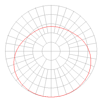 | ||||||||||||||||||
| Azimuth | Ratio | Azimuth | Ratio | Azimuth | Ratio | Azimuth | Ratio | ||||||||||||
| 3 | 0.535 | 13 | 0.540 | 23 | 0.549 | 33 | 0.566 | ||||||||||||
| 43 | 0.592 | 53 | 0.630 | 63 | 0.679 | 73 | 0.735 | ||||||||||||
| 83 | 0.792 | 93 | 0.845 | 103 | 0.892 | 113 | 0.929 | ||||||||||||
| 123 | 0.956 | 133 | 0.975 | 143 | 0.987 | 153 | 0.995 | ||||||||||||
| 163 | 0.999 | 173 | 1.000 | 183 | 0.999 | 193 | 0.995 | ||||||||||||
| 203 | 0.987 | 213 | 0.975 | 223 | 0.956 | 233 | 0.929 | ||||||||||||
| 243 | 0.892 | 253 | 0.845 | 263 | 0.792 | 273 | 0.735 | ||||||||||||
| 283 | 0.679 | 293 | 0.630 | 303 | 0.592 | 313 | 0.566 | ||||||||||||
| 323 | 0.549 | 333 | 0.540 | 343 | 0.535 | 353 | 0.534 | ||||||||||||
Structure Registration Number 1007876 Structure Type: 4TA4 Registered To: Capstar Radio Operating Company Structure Address: Twr 4 13 Summerlin Rd Asheville, NC County Name: Buncombe County ASR Issued: 08/29/2017 Date Built: 11/15/2006 Site Elevation: 672.1 m (2205 ft.) Structure Height: 99.4 m (326 ft.) Height Overall: 100.3 m (329 ft.) Overall Height AMSL: 772.4 m (2534 ft.) FAA Determination: 12/11/2007 FAA Study #: 2007-ASO-6896-OE Paint & Light FAA Chapters: NONE PRIOR STUDY 2006-ASO-2867-OE 35-35-50.8 N 82-36-20.0 W (NAD 83) 35-35-50.4 N 82-36-20.5 W (Converted to NAD 27) |
7136 S. Yale Avenue Suite 501 Tulsa, OK 74136 Phone: 918-664-4581 | Date: 05/25/2017 Application Certifier CAPSTAR TX LLC 2625 S. Memorial Drive, Suite A Tulsa, OK 74129 Applicant TROY G. LANGHAM 2625 South Memorial Drive Suite A Tulsa, OK 74129 FCC ENGINEER OF PRIMARY TROY LANGHAM Iheartmedia, Inc. 2625 S. Memorial Drive, Suite A Tulsa, OK 74129 | |||||||||||||||||