
FCCInfo.com
A Service of Cavell, Mertz & Associates, Inc.
(855) FCC-INFO
|
|
|
|  |
|
|||||||||||||||
|
|
KLTG Channel: 243C1 96.5 MHz Corpus Christi, Texas Service: FM - A full-service FM station or application. Facility ID: 63342 Fac. Service: FM Status: License 73.215 Station Application Accepted: 07/03/2014 Application Granted: 07/10/2014 File Number: BLH-20140703AAM License Expires: 00/00/0000 Prefix Type: This is a license for a commercial FM station Application Type: License To Cover FCC Website Links: LMS Facility Details This Application CDBS Application Other KLTG Applications Other KLTG Applications in CDBS Including Superseded Applications Mailing Address Correspondence for KLTG Correspondence related to application BLH-20140703AAM Service Contour - Open Street Map or USGS Map (60 dBu) Service Contour - KML / Google Earth (60 dBu) Public Inspection Files History Cards for KLTG Facility Type: FM STATION Class: C1, A Zone II station; with 50kW-100kW ERP and a class contour distance 52km-72km Site Location: 28-02-08.1 N 97-26-12.0 W (NAD 83) Site Location: 28-02-07.0 N 97-26-11.0 W (Converted to NAD 27) Effective Radiated Power: 100 kW Transmitter Output Power: 10.44 kW Antenna Center HAAT: 247 m (810 ft.) Antenna Center AMSL: 261 m (856 ft.) Antenna Center HAG: 247 m (810 ft.) Calculated Site Elevation: 14 m. (46 ft.) Height Overall*: 305 m (1001 ft.) (* As Filed In This Application, may differ from ASR Data, Below.) Directional Antenna Antenna Make/Model: Shivley 6810-12R-BB-BT(0.5)-DA, 12 bays, .5 wavelength Antenna ID: 110949 Polarization: | ||||||||||||||||||
| Antenna Data for Antenna Id: 110949 KLTG FM File: BLH-20140703AAM Shivley - 6810-12R-BB-BT(0.5)-DA, 12 bays, .5 wavelength Service: FM | 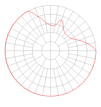 | ||||||||||||||||||
| Azimuth | Ratio | Azimuth | Ratio | Azimuth | Ratio | Azimuth | Ratio | ||||||||||||
| 0 | 0.562 | 10 | 0.562 | 20 | 0.708 | 30 | 0.562 | ||||||||||||
| 40 | 0.501 | 50 | 0.501 | 60 | 0.531 | 70 | 0.668 | ||||||||||||
| 80 | 0.841 | 90 | 1.000 | 100 | 1.000 | 110 | 1.000 | ||||||||||||
| 120 | 1.000 | 130 | 1.000 | 140 | 1.000 | 150 | 1.000 | ||||||||||||
| 160 | 1.000 | 170 | 1.000 | 180 | 1.000 | 190 | 1.000 | ||||||||||||
| 200 | 1.000 | 210 | 1.000 | 220 | 1.000 | 230 | 1.000 | ||||||||||||
| 240 | 1.000 | 250 | 1.000 | 260 | 1.000 | 270 | 1.000 | ||||||||||||
| 280 | 1.000 | 290 | 1.000 | 300 | 1.000 | 310 | 1.000 | ||||||||||||
| 320 | 1.000 | 330 | 1.000 | 340 | 0.794 | 350 | 0.631 | ||||||||||||
Structure Registration Number 1060584 Structure Type: Registered To: Tejas Broadcasting Ltd., LLP Structure Address: 4 Mi E On Hwy 821 Sinton, TX County Name: San Patricio County ASR Issued: 12/18/2018 Date Built: 01/01/1986 Site Elevation: 14.3 m (47 ft.) Structure Height: 304.8 m (1000 ft.) Height Overall: 304.8 m (1000 ft.) Overall Height AMSL: 319.1 m (1047 ft.) FAA Determination: 01/14/1999 FAA Study #: 98-ASW-4898-OE Paint & Light FAA Chapters: 1, 3, 7, 16, 21 28-02-08.0 N 97-26-12.0 W (NAD 83) 28-02-06.9 N 97-26-11.0 W (Converted to NAD 27) |
25410 Prado De Azul Calabasas, CA 91302 Phone: 818-222-9368 Limited Liability Company | Date: 07/03/2014 Application Certifier TEJAS BROADCASTING, LTD, LLP 1227 West Magnolia Avenue Suite 300 Fort Worth, TX 76104 Applicant ERIK C. SWANSON, P.E. Hatfield & Dawson Consulting Engineers 9500 Greenwood Ave N Seattle, WA 98103 CONSULTING ENGINEER ROBERT B. JACOBI Cohn And Marks Llp | |||||||||||||||||
| |||||||||||||||||||