
FCCInfo.com
A Service of Cavell, Mertz & Associates, Inc.
(855) FCC-INFO
|
|
W227CG from 06/21/2007 W227CG from 06/24/2004 |
|
|
||||||||||||||||
|
|
W227CG Channel: 227D 93.3 MHz Grand Rapids, Michigan Service: FX - A translator or application for a translator. Facility ID: 152364 Fac. Service: FX Programming Delivery Method: Unspecified Status: License Application Accepted: 02/25/2015 Application Granted: 03/23/2015 File Number: BLFT-20150225ACR License Expires: 00/00/0000 Prefix Type: This is a license for a translator Application Type: License To Cover FCC Website Links: LMS Facility Details This Application CDBS Application Other W227CG Applications Other W227CG Applications in CDBS Including Superseded Applications Mailing Address Correspondence for W227CG Correspondence related to application BLFT-20150225ACR Service Contour - Open Street Map or USGS Map (60 dBu) Service Contour - KML / Google Earth (60 dBu) Class: D, A Noncommercial educational operating with no more than 10W Site Location: 42-57-13.1 N 85-41-55.1 W (NAD 83) Site Location: 42-57-13.0 N 85-41-55.0 W (Converted to NAD 27) Effective Radiated Power: 0.25 kW Transmitter Output Power: 0.443 kW Antenna Center HAAT: 146 m Horiz.; 0 m Vert. Antenna Center AMSL: 361 m (1184 ft.) Antenna Center HAG: 175 m (574 ft.) Site Elevation: 186 m. (610 ft.) Height Overall*: 193 m (633 ft.) (* As Filed In This Application, may differ from ASR Data, Below.) Directional Antenna Antenna Make/Model: None Antenna ID: 110864 Polarization:
| ||||||||||||||||||
| Antenna Data for Antenna Id: 110864 W227CG FX File: BLFT-20150225ACR None - Service: FX Pattern and Field Values Include a 150° Clockwise Rotation | 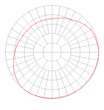 | ||||||||||||||||||
| Azimuth | Ratio | Azimuth | Ratio | Azimuth | Ratio | Azimuth | Ratio | ||||||||||||
| 0 | 0.712 | 10 | 0.732 | 20 | 0.772 | 30 | 0.802 | ||||||||||||
| 40 | 0.853 | 50 | 0.909 | 60 | 0.953 | 70 | 0.973 | ||||||||||||
| 80 | 0.983 | 90 | 1.000 | 100 | 0.992 | 110 | 0.988 | ||||||||||||
| 120 | 0.988 | 130 | 0.983 | 140 | 0.983 | 150 | 0.983 | ||||||||||||
| 160 | 0.983 | 170 | 0.983 | 180 | 0.988 | 190 | 0.988 | ||||||||||||
| 200 | 0.992 | 210 | 1.000 | 220 | 0.991 | 230 | 0.963 | ||||||||||||
| 240 | 0.923 | 250 | 0.873 | 260 | 0.832 | 270 | 0.792 | ||||||||||||
| 280 | 0.762 | 290 | 0.732 | 300 | 0.710 | 310 | 0.702 | ||||||||||||
| 320 | 0.702 | 330 | 0.702 | 340 | 0.702 | 350 | 0.702 | ||||||||||||
Structure Registration Number 1008564 Structure Type: TOWER Registered To: FURNITURE CITY BROADCASTING CORP DBA = WFUR FM Structure Address: 399 Garfield S W Grand Rapids, MI County Name: Kent County ASR Issued: 02/03/1997 Date Built: 01/01/1984 Site Elevation: 186 m (610 ft.) Structure Height: 192 m (630 ft.) Height Overall: 193 m (633 ft.) Overall Height AMSL: 379 m (1243 ft.) FAA Determination: 08/26/1993 FAA Study #: 83-AGL-1274-OE Paint & Light FAA Chapters: 1, 3, 5, 14, 21 RED LIGHTS/PAINT 42-57-13.0 N 85-41-55.0 W (NAD 83) 42-57-12.9 N 85-41-54.9 W (Converted to NAD 27) |
2627 E. Beltline Ave Se Suite 210 Grand Rapids, MI 49546 Phone: 616-451-0551 Limited Liability Company | Date: 02/25/2015 Application Certifier WORLD RADIO LINK, INC. 160 Gooding St. West Suite A Twin Falls, ID 83301 Applicant GENE WISNIEWSKI 160 Gooding Street West Suite A Twin Falls, ID 83301 CONSULTING ENGINEER CLARK PARRISH World Radio Link Incorporated 160 Gooding St. West Suite A Twin Falls, ID 83301 | |||||||||||||||||