
FCCInfo.com
A Service of Cavell, Mertz & Associates, Inc.
(855) FCC-INFO
|
|
WWMX from 03/15/1985 WWMX from 07/14/1983 |
|  |
|
||||||||||||||||||
|
|
WWMX Channel: 293B 106.5 MHz Baltimore, Maryland Service: FS - A full service FM station auxiliary transmitting antenna or application. Facility ID: 74196 Fac. Service: FM Analog & Digital Status: License Application Accepted: 11/16/2017 Application Granted: 12/28/2017 File Number: BXLH-20171116AAC License Expires: 00/00/0000 Prefix Type: This is BXLH Application Type: License To Cover FCC Website Links: LMS Facility Details This Application CDBS Application Other WWMX Applications Other WWMX Applications in CDBS Including Superseded Applications Mailing Address Correspondence for WWMX Correspondence related to application BXLH-20171116AAC Service Contour - Open Street Map or USGS Map (54 dBu) Service Contour - KML / Google Earth (54 dBu) Public Inspection Files History Cards for WWMX Facility Type: FM STATION Class: B, A Zone I or I-A station; with 25kW-50kW ERP and a class contour distance 39km-52km Site Location: 39-25-07.0 N 76-33-16.2 W (NAD 83) Site Location: 39-25-06.6 N 76-33-17.3 W (Converted to NAD 27) Effective Radiated Power: 16 kW Transmitter Output Power: 9.292 kW Antenna Center HAAT: 268 m (879 ft.) Antenna Center AMSL: 364 m (1194 ft.) Antenna Center HAG: 233 m (764 ft.) Calculated Site Elevation: 131 m. (430 ft.) Height Overall*: 256 m (840 ft.) (* As Filed In This Application, may differ from ASR Data, Below.) Directional Antenna Antenna Make/Model: Electronics Research Inc. SHP-4AE-DA-HW, four bay 0.5 wavelength spaced Antenna ID: 126965 Polarization: | |||||||||||||||||||||
| Antenna Data for Antenna Id: 126965 WWMX FS File: BXLH-20171116AAC Electronics Research Inc. - SHP-4AE-DA-HW, four bay 0.5 wavelength spaced Service: FS | 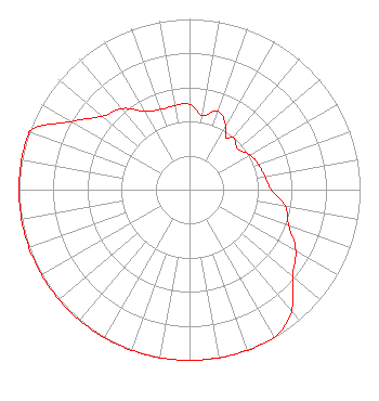 | |||||||||||||||||||||
| Azimuth | Ratio | Azimuth | Ratio | Azimuth | Ratio | Azimuth | Ratio | |||||||||||||||
| 0 | 0.500 | 10 | 0.440 | 20 | 0.490 | 30 | 0.430 | |||||||||||||||
| 35 | 0.370 | 40 | 0.400 | 50 | 0.370 | 60 | 0.410 | |||||||||||||||
| 70 | 0.430 | 80 | 0.450 | 90 | 0.480 | 100 | 0.570 | |||||||||||||||
| 110 | 0.620 | 120 | 0.720 | 130 | 0.790 | 140 | 0.930 | |||||||||||||||
| 150 | 1.000 | 160 | 1.000 | 170 | 1.000 | 180 | 1.000 | |||||||||||||||
| 190 | 1.000 | 200 | 1.000 | 210 | 1.000 | 220 | 1.000 | |||||||||||||||
| 230 | 1.000 | 240 | 1.000 | 250 | 1.000 | 260 | 1.000 | |||||||||||||||
| 270 | 1.000 | 280 | 1.000 | 290 | 1.000 | 300 | 0.800 | |||||||||||||||
| 310 | 0.670 | 320 | 0.620 | 330 | 0.530 | 340 | 0.500 | |||||||||||||||
| 350 | 0.500 | |||||||||||||||||||||
Structure Registration Number 1045612 Structure Type: GTOWER Registered To: K2 Towers III, LLC Structure Address: 1570 Hart Rd Towson, MD County Name: Baltimore County ASR Issued: 03/06/2023 Date Built: 01/01/1972 Site Elevation: 131.1 m (430 ft.) Structure Height: 255.5 m (838 ft.) Height Overall: 256 m (840 ft.) Overall Height AMSL: 387.1 m (1270 ft.) FAA Determination: 02/27/2015 FAA Study #: 2015-AEA-242-OE FAA Circular #: 70/7460-1K Paint & Light FAA Chapters: 3, 4, 5, 12 Removed expiration date from determination. Scenario 1./jjs/case#635066 39-25-07.0 N 76-33-16.2 W (NAD 83) 39-25-06.6 N 76-33-17.3 W (Converted to NAD 27) |
2400 Market Street 4th Floor Philadelphia, PA 19103 Phone: 610-660-5610 Limited Liability Company | Date: 11/16/2017 Application Certifier CBS RADIO STATIONS INC. 1725 Desales St Nw Suite 501 Washington, DC 20036-4426 Applicant DANIEL G. RYSON Cbs 1725 Desales St. Nw, Suite 501 Washington, DC 20036-4426 EMPLOYEE OF PARENT CORPORATION DANIEL G. RYSON Cbs | ||||||||||||||||||||
| ||||||||||||||||||||||