
FCCInfo.com
A Service of Cavell, Mertz & Associates, Inc.
(855) FCC-INFO
|
|
W260CA from 03/17/1997 |
|
|
||||||||||||||||
|
|
W260CA Channel: 260D 99.9 MHz Sebring, Florida Service: FX - A translator or application for a translator. Facility ID: 83599 Fac. Service: FX Programming Delivery Method: Unspecified Status: License Application Accepted: 12/11/2009 Application Granted: 12/23/2009 File Number: BLFT-20091211AER License Expires: 00/00/0000 Prefix Type: This is a license for a translator Application Type: License To Cover FCC Website Links: LMS Facility Details This Application CDBS Application Other W260CA Applications Other W260CA Applications in CDBS Including Superseded Applications Mailing Address Correspondence for W260CA Correspondence related to application BLFT-20091211AER Service Contour - Open Street Map or USGS Map (60 dBu) Service Contour - KML / Google Earth (60 dBu) Class: D, A Noncommercial educational operating with no more than 10W Site Location: 27-30-40.1 N 81-31-53.3 W (NAD 83) Site Location: 27-30-39.0 N 81-31-54.0 W (Converted to NAD 27) Effective Radiated Power: 0.055 kW Transmitter Output Power: 0.16 kW Antenna Center HAAT: 59.3 m Horiz.; 0 m Vert. Antenna Center AMSL: 87 m (285 ft.) Antenna Center HAG: 42 m (138 ft.) Site Elevation: 45 m. (148 ft.) Height Overall*: 152 m (499 ft.) (* As Filed In This Application, may differ from ASR Data, Below.) Directional Antenna Antenna Make/Model: None Antenna ID: 96844 Polarization:
| ||||||||||||||||||
| Antenna Data for Antenna Id: 96844 W260CA FX File: BLFT-20091211AER None - Service: FX Pattern and Field Values Include a 90° Clockwise Rotation | 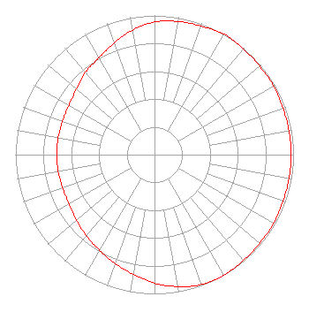 | ||||||||||||||||||
| Azimuth | Ratio | Azimuth | Ratio | Azimuth | Ratio | Azimuth | Ratio | ||||||||||||
| 0 | 0.953 | 10 | 0.972 | 20 | 0.982 | 30 | 1.000 | ||||||||||||
| 40 | 0.991 | 50 | 0.988 | 60 | 0.988 | 70 | 0.982 | ||||||||||||
| 80 | 0.982 | 90 | 0.982 | 100 | 0.982 | 110 | 0.982 | ||||||||||||
| 120 | 0.988 | 130 | 0.988 | 140 | 0.993 | 150 | 1.000 | ||||||||||||
| 160 | 0.993 | 170 | 0.962 | 180 | 0.923 | 190 | 0.873 | ||||||||||||
| 200 | 0.832 | 210 | 0.792 | 220 | 0.762 | 230 | 0.732 | ||||||||||||
| 240 | 0.710 | 250 | 0.703 | 260 | 0.703 | 270 | 0.703 | ||||||||||||
| 280 | 0.703 | 290 | 0.703 | 300 | 0.711 | 310 | 0.732 | ||||||||||||
| 320 | 0.772 | 330 | 0.802 | 340 | 0.853 | 350 | 0.909 | ||||||||||||
Structure Registration Number 1013373 Structure Type: TOWER Registered To: Cohan Radio Group, Inc. Structure Address: Schumacher Road Sebring, FL County Name: Highlands County ASR Issued: 12/06/2002 Date Built: 09/01/1997 Site Elevation: 44.8 m (147 ft.) Structure Height: 148 m (486 ft.) Height Overall: 152 m (499 ft.) Overall Height AMSL: 196.8 m (646 ft.) FAA Determination: 02/11/1997 FAA Study #: 96-ASO-4205-OE FAA Circular #: 70/7460-1J Paint & Light FAA Chapters: 3, 4, 5, 13 27-30-40.0 N 81-31-53.0 W (NAD 83) 27-30-38.9 N 81-31-53.7 W (Converted to NAD 27) |
11530 Carmel Commons Blvd Charlotte, NC 28226-3976 Phone: 704-523-5555 | Date: 12/11/2009 Application Certifier BIBLE BROADCASTING NETWORK, INC. 11530 Carmel Commons Boulevard Charlotte, NC 28226 Applicant JUSTIN W. ASHER Munn-reese, Inc. Po Box 220, 385 Airport Dr. Coldwater, MI 49036-0220 CONSULTING ENGINEER GARY S. SMITHWICK Smithwick & Belendiuk, P.c. 5028 Wisconsin Avenue, Nw Suite 301 Washington, DC 20016 | |||||||||||||||||