
FCCInfo.com
A Service of Cavell, Mertz & Associates, Inc.
(855) FCC-INFO
|
|
WFLC from 09/19/1986 |
|  |
|
||||||||||||||||||||||||
|
|
WFLC Channel: 247C 97.3 MHz Miami, Florida Service: FM - A full-service FM station or application. Facility ID: 72984 Fac. Service: FM Analog & Digital Status: License Application Accepted: 02/24/2005 Application Granted: 03/21/2005 File Number: BLH-20050224ABL License Expires: 00/00/0000 Prefix Type: This is a license for a commercial FM station Application Type: License To Cover FCC Website Links: LMS Facility Details This Application CDBS Application Other WFLC Applications Other WFLC Applications in CDBS Including Superseded Applications Mailing Address Correspondence for WFLC Correspondence related to application BLH-20050224ABL Service Contour - Open Street Map or USGS Map (60 dBu) Service Contour - KML / Google Earth (60 dBu) Public Inspection Files History Cards for WFLC Facility Type: FM STATION Class: C, A Zone II station; with exactly 100kW ERP and a class contour distance 72km-92km Site Location: 25-58-03.3 N 80-12-33.2 W (NAD 83) Site Location: 25-58-02.0 N 80-12-34.0 W (Converted to NAD 27) Effective Radiated Power: 100 kW Transmitter Output Power: 16.11 kW Antenna Center HAAT: 307 m (1007 ft.) Antenna Center AMSL: 308 m (1010 ft.) Antenna Center HAG: 306 m (1004 ft.) Calculated Site Elevation: 2 m. (7 ft.) Height Overall*: 317.6 m (1042 ft.) (* As Filed In This Application, may differ from ASR Data, Below.) Directional Antenna Antenna Make/Model: Electronics Research Inc. COG1084-8CP-DA, 8 sections Antenna ID: 64728 Polarization: | |||||||||||||||||||||||||||
| Antenna Data for Antenna Id: 64728 WFLC FM File: BLH-20050224ABL Electronics Research Inc. - COG1084-8CP-DA, 8 sections Service: FM | 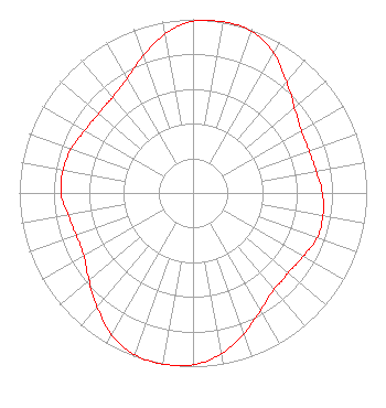 | |||||||||||||||||||||||||||
| Azimuth | Ratio | Azimuth | Ratio | Azimuth | Ratio | Azimuth | Ratio | |||||||||||||||||||||
| 0 | 0.990 | 10 | 1.000 | 20 | 0.990 | 30 | 0.930 | |||||||||||||||||||||
| 40 | 0.840 | 45 | 0.800 | 50 | 0.760 | 60 | 0.720 | |||||||||||||||||||||
| 70 | 0.710 | 80 | 0.720 | 90 | 0.745 | 100 | 0.760 | |||||||||||||||||||||
| 110 | 0.760 | 120 | 0.732 | 130 | 0.715 | 135 | 0.720 | |||||||||||||||||||||
| 140 | 0.725 | 150 | 0.780 | 160 | 0.860 | 170 | 0.940 | |||||||||||||||||||||
| 180 | 0.990 | 190 | 1.000 | 200 | 0.990 | 210 | 0.940 | |||||||||||||||||||||
| 220 | 0.860 | 225 | 0.820 | 230 | 0.780 | 240 | 0.725 | |||||||||||||||||||||
| 250 | 0.715 | 260 | 0.730 | 270 | 0.760 | 280 | 0.760 | |||||||||||||||||||||
| 290 | 0.745 | 300 | 0.720 | 310 | 0.710 | 315 | 0.715 | |||||||||||||||||||||
| 320 | 0.720 | 330 | 0.760 | 340 | 0.840 | 350 | 0.930 | |||||||||||||||||||||
Structure Registration Number 1028046 Structure Type: GTOWER Registered To: American Towers LLC Structure Address: 390 Nw 210th Street (#75010) Miami, FL County Name: Miami-Dade County ASR Issued: 05/11/2023 Date Built: 07/01/1983 Site Elevation: 2.1 m (7 ft.) Structure Height: 316.1 m (1037 ft.) Height Overall: 317.6 m (1042 ft.) Overall Height AMSL: 319.7 m (1049 ft.) FAA Determination: 04/30/2022 FAA Study #: 2021-ASO-33602-OE FAA Circular #: 70/7460-1M Paint & Light FAA Chapters: 4, 9, 15 PRIOR STUDY 2010-ASO-473-OE 25-58-03.7 N 80-12-33.2 W (NAD 83) 25-58-02.4 N 80-12-34.0 W (Converted to NAD 27) |
1601 W Peachtree Street Ne Atlanta, GA 30309 Phone: 404-897-7000 Limited Liability Company | Date: 02/24/2005 Application Certifier COX RADIO, INC. 2741 N. 29th Avenue Hollywood, FL 33020 Applicant FREDERICK D. VEIHMEYER Lohnes And Culver 8309 Cherry Lane Laurel, MD 20707 CONSULTANT KEVIN F. REED, ESQ. Dow Lohnes Pllc | ||||||||||||||||||||||||||
|
| |||||||||||||||||||||||||||