
FCCInfo.com
A Service of Cavell, Mertz & Associates, Inc.
(855) FCC-INFO
|
|
W263DB from 05/31/2017 W263DB from 02/11/2016 W263DB from 06/06/2014 |
|
|
||||||||||||||||
|
|
W263DB Channel: 263D 100.5 MHz Lancaster, Pennsylvania Service: FX - A translator or application for a translator. Facility ID: 144779 Fac. Service: FX Programming Delivery Method: Unspecified Status: License Application Accepted: 10/12/2017 Application Granted: 10/24/2017 File Number: BLFT-20171012AAL License Expires: 00/00/0000 Prefix Type: This is a license for a translator Application Type: License To Cover FCC Website Links: LMS Facility Details This Application CDBS Application Other W263DB Applications Other W263DB Applications in CDBS Including Superseded Applications Mailing Address Correspondence for W263DB Correspondence related to application BLFT-20171012AAL Service Contour - Open Street Map or USGS Map (60 dBu) Service Contour - KML / Google Earth (60 dBu) Class: D, A Noncommercial educational operating with no more than 10W Site Location: 40-02-17.4 N 76-18-21.9 W (NAD 83) Site Location: 40-02-17.0 N 76-18-23.0 W (Converted to NAD 27) Effective Radiated Power: 0 kW Horiz. ; 0.25 kW Vert. Transmitter Output Power: 0.347 kW Antenna Center HAAT: 0 m Antenna Center AMSL: 0 m Horiz.; 171 m Vert. Antenna Center HAG: 0 m Horiz.; 62 m Vert. Site Elevation: 109 m. (358 ft.) Height Overall*: 79 m (259 ft.) (* As Filed In This Application, may differ from ASR Data, Below.) Directional Antenna Antenna Make/Model: None Antenna ID: 129399 Polarization:
| ||||||||||||||||||
| Antenna Data for Antenna Id: 129399 W263DB FX File: BLFT-20171012AAL None - Service: FX | 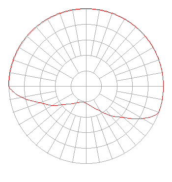 | ||||||||||||||||||
| Azimuth | Ratio | Azimuth | Ratio | Azimuth | Ratio | Azimuth | Ratio | ||||||||||||
| 0 | 1.000 | 10 | 1.000 | 20 | 1.000 | 30 | 1.000 | ||||||||||||
| 40 | 1.000 | 50 | 1.000 | 60 | 1.000 | 70 | 1.000 | ||||||||||||
| 80 | 1.000 | 90 | 1.000 | 100 | 1.000 | 110 | 1.000 | ||||||||||||
| 120 | 0.840 | 130 | 0.630 | 140 | 0.500 | 150 | 0.370 | ||||||||||||
| 160 | 0.300 | 170 | 0.250 | 180 | 0.220 | 190 | 0.210 | ||||||||||||
| 200 | 0.220 | 210 | 0.250 | 220 | 0.300 | 230 | 0.370 | ||||||||||||
| 240 | 0.500 | 250 | 0.630 | 260 | 0.840 | 270 | 1.000 | ||||||||||||
| 280 | 1.000 | 290 | 1.000 | 300 | 1.000 | 310 | 1.000 | ||||||||||||
| 320 | 1.000 | 330 | 1.000 | 340 | 1.000 | 350 | 1.000 | ||||||||||||
Structure Registration Number 1044369 Structure Type: TOWER Registered To: Commercial Sound and Communications Structure Address: W King & N Queen Sts Lancaster, PA County Name: Lancaster County ASR Issued: 05/08/2012 Date Built: 01/01/1977 Site Elevation: 108.8 m (357 ft.) Structure Height: 64.3 m (211 ft.) Height Overall: 78.6 m (258 ft.) Overall Height AMSL: 187.4 m (615 ft.) FAA Determination: 10/06/1976 FAA Study #: 76-EA-918-OE FAA Circular #: 70/7460-1D Paint & Light FAA Chapters: 3, 4, 5, 9 PREVIOUS STUDY #75-EA-1067 40-02-17.4 N 76-18-21.9 W (NAD 83) 40-02-17.0 N 76-18-23.0 W (Converted to NAD 27) |
7136 S. Yale Avenue Suite 501 Tulsa, OK 74136 Phone: 918-664-4581 | Date: 10/12/2017 Application Certifier CAPSTAR TX LLC 7136 S. Yale Avenue Suite 501 Tulsa, OK 74136 Applicant MICHAEL GUIDOTTI 111 Presidential Blvd Bala Cynwyd, PA 19004 REGIONAL ENGINEER CAPSTAR TX LLC Capstar Tx Llc 7136 S. Yale Avenue Suite 501 Tulsa, OK 74136 | |||||||||||||||||