
FCCInfo.com
A Service of Cavell, Mertz & Associates, Inc.
(855) FCC-INFO
|
|
K214ET from 08/26/1996 |
|
|
||||||||||||||||
|
|
K214ET Channel: 214D 90.7 MHz San Luis Obispo, California Service: FX - A translator or application for a translator. Facility ID: 77025 Fac. Service: FX Programming Delivery Method: Unspecified Status: License Application Accepted: 05/17/2011 Application Granted: 06/09/2011 File Number: BLFT-20110517ADY License Expires: 00/00/0000 Prefix Type: This is a license for a translator Application Type: License To Cover FCC Website Links: LMS Facility Details This Application CDBS Application Other K214ET Applications Other K214ET Applications in CDBS Including Superseded Applications Mailing Address Correspondence for K214ET Correspondence related to application BLFT-20110517ADY Service Contour - Open Street Map or USGS Map (60 dBu) Service Contour - KML / Google Earth (60 dBu) Class: D, A Noncommercial educational operating with no more than 10W Site Location: 35-21-36.9 N 120-39-21.6 W (NAD 83) Site Location: 35-21-37.0 N 120-39-18.0 W (Converted to NAD 27) Effective Radiated Power: 0 kW Horiz. ; 0.005 kW Vert. Transmitter Output Power: 0.01 kW Antenna Center HAAT: 501.8 m Horiz.; 0 m Vert. Antenna Center AMSL: 0 m Horiz.; 828 m Vert. Antenna Center HAG: 0 m Horiz.; 83 m Vert. Site Elevation: 745 m. (2444 ft.) Height Overall*: 141 m (463 ft.) (* As Filed In This Application, may differ from ASR Data, Below.) Directional Antenna Antenna Make/Model: None Antenna ID: 104513 Polarization:
| ||||||||||||||||||
| Antenna Data for Antenna Id: 104513 K214ET FX File: BLFT-20110517ADY None - Service: FX Pattern and Field Values Include a 65° Clockwise Rotation | 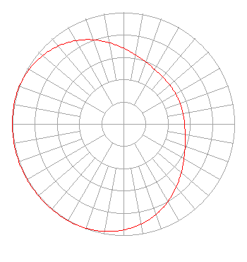 | ||||||||||||||||||
| Azimuth | Ratio | Azimuth | Ratio | Azimuth | Ratio | Azimuth | Ratio | ||||||||||||
| 5 | 0.653 | 15 | 0.607 | 25 | 0.575 | 35 | 0.555 | ||||||||||||
| 45 | 0.546 | 55 | 0.542 | 65 | 0.541 | 75 | 0.542 | ||||||||||||
| 85 | 0.546 | 95 | 0.555 | 105 | 0.575 | 115 | 0.607 | ||||||||||||
| 125 | 0.653 | 135 | 0.709 | 145 | 0.771 | 155 | 0.833 | ||||||||||||
| 165 | 0.888 | 175 | 0.933 | 185 | 0.966 | 195 | 0.988 | ||||||||||||
| 205 | 0.999 | 215 | 1.000 | 225 | 1.000 | 235 | 1.000 | ||||||||||||
| 245 | 1.000 | 255 | 1.000 | 265 | 1.000 | 275 | 1.000 | ||||||||||||
| 285 | 0.999 | 295 | 0.988 | 305 | 0.966 | 315 | 0.933 | ||||||||||||
| 325 | 0.888 | 335 | 0.833 | 345 | 0.771 | 355 | 0.709 | ||||||||||||
Structure Registration Number 1018365 Structure Type: GTOWER Registered To: Scripps Broadcasting Holdings LLC Structure Address: Atop Cuesta Peak San Luis Obispo, CA County Name: San Luis Obispo County ASR Issued: 07/25/2019 Date Built: 01/02/2020 Site Elevation: 745.2 m (2445 ft.) Structure Height: 122.5 m (402 ft.) Height Overall: 141.1 m (463 ft.) Overall Height AMSL: 886.3 m (2908 ft.) FAA Determination: 07/17/2019 FAA Study #: 2019-AWP-6925-OE FAA Circular #: 70/7460-1L Paint & Light FAA Chapters: 4, 6, 12 PRIOR STUDY 1997-AWP-687-OE 35-21-37.2 N 120-39-21.1 W (NAD 83) 35-21-37.3 N 120-39-17.5 W (Converted to NAD 27) |
P.o. Box 391 4002 N. 3300 E. Twin Falls, ID 83303 Phone: 208-733-3133 | Date: 05/17/2011 Application Certifier CALVARY CHAPEL OF TWIN FALLS, INC. Po Box 391 Twin Falls, ID 83303 Applicant LOIS MILLS Po Box 391 Twin Falls, ID 83303 APPLICATION TECHNICIAN CARY TEPPER Booth, Freret, Imlay And Tepper, Pc 7900 Wisconsin Ave, Suite 304 Bethesda, MD 20814-3628 | |||||||||||||||||