
FCCInfo.com
A Service of Cavell, Mertz & Associates, Inc.
(855) FCC-INFO
|
|
|
|
|
||||||||||||||||
|
|
K261EG Channel: 261D 100.1 MHz Aspen, Colorado Service: FX - A translator or application for a translator. Facility ID: 156601 Fac. Service: FX Programming Delivery Method: Unspecified Status: License Application Accepted: 10/31/2016 Application Granted: 11/25/2016 File Number: BLFT-20161031AAK License Expires: 00/00/0000 Prefix Type: This is a license for a translator Application Type: License To Cover FCC Website Links: LMS Facility Details This Application CDBS Application Other K261EG Applications Other K261EG Applications in CDBS Including Superseded Applications Mailing Address Correspondence for K261EG Correspondence related to application BLFT-20161031AAK Service Contour - Open Street Map or USGS Map (60 dBu) Service Contour - KML / Google Earth (60 dBu) Class: D, A Noncommercial educational operating with no more than 10W Site Location: 39-13-16.0 N 106-48-49.1 W (NAD 83) Site Location: 39-13-16.0 N 106-48-47.0 W (Converted to NAD 27) Effective Radiated Power: 0.025 kW Horiz. ; 0 kW Vert. Transmitter Output Power: 0.01 kW Antenna Center HAAT: 0 m Antenna Center AMSL: 3193 m Horiz.; 0 m Vert. Antenna Center HAG: 16 m Horiz.; 0 m Vert. Site Elevation: 3177 m. (10423 ft.) Height Overall*: 24 m (79 ft.) (* As Filed In This Application, may differ from ASR Data, Below.) Directional Antenna Antenna Make/Model: None Antenna ID: 16150 Polarization:
| ||||||||||||||||||
| Antenna Data for Antenna Id: 16150 K261EG FX File: BLFT-20161031AAK None - Service: FX Pattern and Field Values Include a 200° Clockwise Rotation | 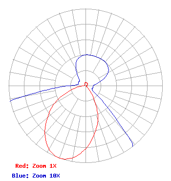 | ||||||||||||||||||
| Azimuth | Ratio | Azimuth | Ratio | Azimuth | Ratio | Azimuth | Ratio | ||||||||||||
| 0 | 0.040 | 10 | 0.040 | 20 | 0.040 | 30 | 0.040 | ||||||||||||
| 40 | 0.040 | 50 | 0.038 | 60 | 0.034 | 70 | 0.025 | ||||||||||||
| 80 | 0.015 | 90 | 0.010 | 100 | 0.010 | 110 | 0.010 | ||||||||||||
| 120 | 0.010 | 130 | 0.020 | 140 | 0.085 | 150 | 0.250 | ||||||||||||
| 160 | 0.470 | 170 | 0.645 | 180 | 0.820 | 190 | 0.950 | ||||||||||||
| 200 | 1.000 | 210 | 0.950 | 220 | 0.820 | 230 | 0.645 | ||||||||||||
| 240 | 0.470 | 250 | 0.250 | 260 | 0.085 | 270 | 0.020 | ||||||||||||
| 280 | 0.010 | 290 | 0.010 | 300 | 0.010 | 310 | 0.010 | ||||||||||||
| 320 | 0.015 | 330 | 0.025 | 340 | 0.034 | 350 | 0.038 | ||||||||||||
Structure Registration Number 1029228 Structure Type: TOWER Registered To: Colorado Radio Marketing LLC Structure Address: Top Of Red Mountain Aspen, CO County Name: Pitkin County ASR Issued: 07/19/2016 Date Built: 07/15/1992 Site Elevation: 3177 m (10423 ft.) Structure Height: 18 m (59 ft.) Height Overall: 24 m (79 ft.) Overall Height AMSL: 3201 m (10502 ft.) FAA Determination: 02/05/1992 FAA Study #: 91-ANM-1012-OE Paint & Light FAA Chapters: NONE 39-13-16.0 N 106-48-49.0 W (NAD 83) 39-13-16.0 N 106-48-46.9 W (Converted to NAD 27) |
97 Cheyenne Avenue Carbondale, CO 81623 Phone: 970-309-3623 Limited Liability Company | Date: 10/31/2016 Application Certifier BS&T WIRELESS, INC. Po Box 1099 Santa Monica, CA 90406-1099 Applicant JON V BANKS 1015 Park West Drive Glenwood Springs, CO 81601 TECHNICAL CONSULTANT MEREDITH S. SENTER, JR. Lerman Senter Pllc 2000 K Street, Nw Suite 600 Washington, DC 20006-1809 | |||||||||||||||||