
FCCInfo.com
A Service of Cavell, Mertz & Associates, Inc.
(855) FCC-INFO
|
|
WORI from 12/20/1993 WORI from 07/23/1993 |
|
|
||||||||||||||||
|
|
WORI Channel: 211B1 90.1 MHz Harrison, Ohio Service: FM - A full-service FM station or application. Facility ID: 38459 Fac. Service: FM Status: License Application Accepted: 05/31/2012 Application Granted: 06/11/2012 File Number: BLED-20120531ADR License Expires: 00/00/0000 Prefix Type: This is a license for a noncommercial educational FM station Application Type: License To Cover FCC Website Links: LMS Facility Details This Application CDBS Application Other WORI Applications Other WORI Applications in CDBS Including Superseded Applications Mailing Address Correspondence for WORI Correspondence related to application BLED-20120531ADR Service Contour - Open Street Map or USGS Map (60 dBu) Service Contour - KML / Google Earth (60 dBu) Public Inspection Files Facility Type: NON-COMMERCIAL EDUC. FM Class: B1, A Zone I or I-A station; with 6kW-25kW ERP and a class contour distance 28km-39km Site Location: 39-13-34.2 N 84-42-58.8 W (NAD 83) Site Location: 39-13-34.0 N 84-42-59.0 W (Converted to NAD 27) Effective Radiated Power: 15 kW Transmitter Output Power: 8.604 kW Antenna Center HAAT: 102 m (335 ft.) Antenna Center AMSL: 320 m (1050 ft.) Antenna Center HAG: 119 m (390 ft.) Calculated Site Elevation: 201 m. (659 ft.) Height Overall*: 123 m (404 ft.) (* As Filed In This Application, may differ from ASR Data, Below.) Directional Antenna Antenna Make/Model: Electronics Research Inc. LP-3E-DA-HW, 3 sections, 0.5 wavelength spaced Antenna ID: 94081 Polarization: | ||||||||||||||||||
| Antenna Data for Antenna Id: 94081 WORI FM File: BLED-20120531ADR Electronics Research Inc. - LP-3E-DA-HW, 3 sections, 0.5 wavelength spaced Service: FM | 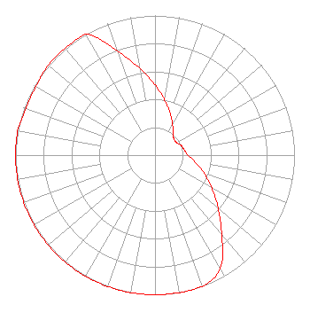 | ||||||||||||||||||
| Azimuth | Ratio | Azimuth | Ratio | Azimuth | Ratio | Azimuth | Ratio | ||||||||||||
| 0 | 0.502 | 10 | 0.399 | 20 | 0.317 | 30 | 0.252 | ||||||||||||
| 40 | 0.200 | 50 | 0.178 | 60 | 0.178 | 70 | 0.200 | ||||||||||||
| 80 | 0.214 | 90 | 0.235 | 100 | 0.296 | 110 | 0.373 | ||||||||||||
| 120 | 0.470 | 130 | 0.591 | 140 | 0.745 | 150 | 0.937 | ||||||||||||
| 160 | 1.000 | 170 | 1.000 | 180 | 1.000 | 190 | 1.000 | ||||||||||||
| 200 | 1.000 | 210 | 1.000 | 220 | 1.000 | 230 | 1.000 | ||||||||||||
| 240 | 1.000 | 250 | 1.000 | 260 | 1.000 | 270 | 1.000 | ||||||||||||
| 280 | 1.000 | 290 | 0.985 | 300 | 0.985 | 310 | 1.000 | ||||||||||||
| 320 | 1.000 | 330 | 1.000 | 340 | 0.796 | 350 | 0.632 | ||||||||||||
Structure Registration Number 1056913 Structure Type: TOWER Registered To: Clearview Tower Company III, LLC Structure Address: Buena Vista Rd Miamitown, OH County Name: Hamilton County ASR Issued: 09/19/2023 Date Built: 11/15/1999 Site Elevation: 201.1 m (660 ft.) Structure Height: 121.8 m (400 ft.) Height Overall: 122.8 m (403 ft.) Overall Height AMSL: 323.9 m (1063 ft.) FAA Determination: 12/21/2000 FAA Study #: 00-AGL-8898-OE FAA Circular #: 70/7460-1J Paint & Light FAA Chapters: 3, 4, 5, 13 39-13-34.0 N 84-42-59.0 W (NAD 83) 39-13-33.8 N 84-42-59.2 W (Converted to NAD 27) |
5700 West Oaks Boulevard Rocklin, CA 95765 Phone: 916-251-1600 Not-for-Profit | Date: 05/31/2012 Application Certifier EDUCATIONAL MEDIA FOUNDATION 5700 West Oaks Blvd Rocklin, CA 95765 Applicant SAM WALLINGTON 5700 West Oaks Blvd Rocklin, CA 95765 VP OF ENGINEERING KAREN A. ROSS, ESQ Davis Wright Tremaine Llp | |||||||||||||||||