
FCCInfo.com
A Service of Cavell, Mertz & Associates, Inc.
(855) FCC-INFO
|
|
WNCH from 09/04/2003 WNCH from 11/22/1996 |
|  |
|
|||||||||||||||
|
|
WNCH Channel: 201B 88.1 MHz Norwich, Vermont Service: FM - A full-service FM station or application. Facility ID: 84441 Fac. Service: FM Analog & Digital Status: License Application Accepted: 08/21/2012 Application Granted: 08/24/2012 File Number: BMLED-20120821ABW License Expires: 00/00/0000 Prefix Type: This is a modification of license for a noncommercial educational FM station Application Type: Minor Modification FCC Website Links: LMS Facility Details This Application CDBS Application Other WNCH Applications Other WNCH Applications in CDBS Including Superseded Applications Mailing Address Correspondence for WNCH Correspondence related to application BMLED-20120821ABW Service Contour - Open Street Map or USGS Map (60 dBu) Service Contour - KML / Google Earth (60 dBu) Public Inspection Files Facility Type: NON-COMMERCIAL EDUC. FM Class: B, A Zone I or I-A station; with 25kW-50kW ERP and a class contour distance 39km-52km Site Location: 43-26-15.3 N 72-27-06.3 W (NAD 83) Site Location: 43-26-15.0 N 72-27-08.0 W (Converted to NAD 27) Effective Radiated Power: 1.55 kW Transmitter Output Power: 1.07 kW Antenna Center HAAT: 686.2 m (2251 ft.) Antenna Center AMSL: 973 m (3192 ft.) Antenna Center HAG: 100.5 m (330 ft.) Calculated Site Elevation: 872.5 m. (2863 ft.) Height Overall*: 129 m (423 ft.) (* As Filed In This Application, may differ from ASR Data, Below.) Directional Antenna Antenna Make/Model: Shivley 6014-2/3R-DA, TWO SECTIONS Antenna ID: 106460 Polarization:
| ||||||||||||||||||
| Antenna Data for Antenna Id: 106460 WNCH FM File: BMLED-20120821ABW Shivley - 6014-2/3R-DA, TWO SECTIONS Service: FM | 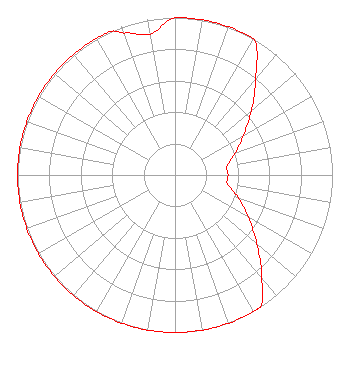 | ||||||||||||||||||
| Azimuth | Ratio | Azimuth | Ratio | Azimuth | Ratio | Azimuth | Ratio | ||||||||||||
| 0 | 1.000 | 10 | 1.000 | 20 | 1.000 | 30 | 1.000 | ||||||||||||
| 40 | 0.796 | 50 | 0.632 | 60 | 0.502 | 70 | 0.409 | ||||||||||||
| 80 | 0.337 | 90 | 0.337 | 100 | 0.340 | 110 | 0.428 | ||||||||||||
| 120 | 0.539 | 130 | 0.678 | 140 | 0.854 | 147 | 1.000 | ||||||||||||
| 150 | 1.000 | 160 | 1.000 | 170 | 1.000 | 180 | 1.000 | ||||||||||||
| 190 | 1.000 | 200 | 1.000 | 210 | 1.000 | 220 | 1.000 | ||||||||||||
| 230 | 1.000 | 240 | 1.000 | 250 | 1.000 | 260 | 1.000 | ||||||||||||
| 270 | 1.000 | 280 | 1.000 | 290 | 1.000 | 300 | 1.000 | ||||||||||||
| 310 | 1.000 | 320 | 1.000 | 330 | 1.000 | 336 | 1.000 | ||||||||||||
| 340 | 0.959 | 350 | 0.909 | ||||||||||||||||
Structure Registration Number 1060721 Structure Type: LTOWER Registered To: Vermont Public Co. Structure Address: Mount Ascutney Windsor, VT County Name: Windsor County ASR Issued: 07/01/2021 Date Built: 06/11/2021 Site Elevation: 872 m (2861 ft.) Structure Height: 116 m (381 ft.) Height Overall: 129.1 m (424 ft.) Overall Height AMSL: 1001.1 m (3284 ft.) FAA Determination: 08/28/2020 FAA Study #: 2020-ANE-5022-OE FAA Circular #: 70/7460-1L Paint & Light FAA Chapters: 4, 8, 12 43-26-15.0 N 72-27-06.0 W (NAD 83) 43-26-14.7 N 72-27-07.7 W (Converted to NAD 27) |
365 Troy Avenue Colchester, VT 05446 Phone: 802-846-8309 | Date: 08/21/2012 Application Certifier VERMONT PUBLIC RADIO 365 Troy Ave Colchester, VT 05446 Applicant RICH PARKER Vermont Public Radio 365 Troy Avenue Colchester, VT 05446 DIRECTOR OF ENGINEERING JOHN CRIGLER, ESQ. Garvey Schubert Barer | |||||||||||||||||