
FCCInfo.com
A Service of Cavell, Mertz & Associates, Inc.
(855) FCC-INFO
|
|
|
|
|
||||||||||||||||
|
|
W227AQ Channel: 227D 93.3 MHz Burlington, Vermont Service: FX - A translator or application for a translator. Facility ID: 145050 Fac. Service: FX Programming Delivery Method: Unspecified Status: License Application Accepted: 01/27/2017 Application Granted: 02/08/2017 File Number: BLFT-20170127ACF License Expires: 00/00/0000 Prefix Type: This is a license for a translator Application Type: License To Cover FCC Website Links: LMS Facility Details This Application CDBS Application Other W227AQ Applications Other W227AQ Applications in CDBS Including Superseded Applications Mailing Address Correspondence for W227AQ Correspondence related to application BLFT-20170127ACF Service Contour - Open Street Map or USGS Map (60 dBu) Service Contour - KML / Google Earth (60 dBu) Class: D, A Noncommercial educational operating with no more than 10W Site Location: 44-29-50.2 N 73-12-49.5 W (NAD 83) Site Location: 44-29-50.0 N 73-12-51.0 W (Converted to NAD 27) Effective Radiated Power: 0.22 kW Transmitter Output Power: 0.15 kW Antenna Center HAAT: 0 m Antenna Center AMSL: 153 m (502 ft.) Antenna Center HAG: 122 m (400 ft.) Site Elevation: 31 m. (102 ft.) Height Overall*: 136 m (446 ft.) (* As Filed In This Application, may differ from ASR Data, Below.) Directional Antenna Antenna Make/Model: None Antenna ID: 126681 Polarization:
| ||||||||||||||||||
| Antenna Data for Antenna Id: 126681 W227AQ FX File: BLFT-20170127ACF None - Service: FX Pattern and Field Values Include a 126° Clockwise Rotation | 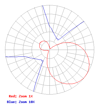 | ||||||||||||||||||
| Azimuth | Ratio | Azimuth | Ratio | Azimuth | Ratio | Azimuth | Ratio | ||||||||||||
| 6 | 0.046 | 16 | 0.037 | 26 | 0.032 | 36 | 0.030 | ||||||||||||
| 46 | 0.045 | 56 | 0.187 | 66 | 0.388 | 76 | 0.570 | ||||||||||||
| 86 | 0.715 | 96 | 0.829 | 106 | 0.920 | 116 | 0.979 | ||||||||||||
| 126 | 1.000 | 136 | 0.979 | 146 | 0.920 | 156 | 0.829 | ||||||||||||
| 166 | 0.715 | 176 | 0.570 | 186 | 0.388 | 196 | 0.187 | ||||||||||||
| 206 | 0.045 | 216 | 0.030 | 226 | 0.032 | 236 | 0.037 | ||||||||||||
| 246 | 0.046 | 256 | 0.065 | 266 | 0.142 | 276 | 0.202 | ||||||||||||
| 286 | 0.234 | 296 | 0.250 | 306 | 0.260 | 316 | 0.250 | ||||||||||||
| 326 | 0.234 | 336 | 0.202 | 346 | 0.142 | 356 | 0.065 | ||||||||||||
Structure Registration Number 1042292 [ASR Heights Differ from W227AQ Application] Structure Type: GTOWER Registered To: Independent Digital & Wireless, Inc. Structure Address: Twr 1 Intervale Rd Burlington, VT County Name: Chittenden County ASR Issued: 02/16/2021 Date Built: 02/16/2021 Site Elevation: 31.4 m (103 ft.) Structure Height: 137 m (449 ft.) Height Overall: 137 m (449 ft.) Overall Height AMSL: 168.4 m (552 ft.) FAA Determination: 02/05/2021 FAA Study #: 2021-ANE-367-OE FAA Circular #: 70/7460-1K Paint & Light FAA Chapters: 3, 4, 5, 12 OM&L to remain the same as prior study = PAINT/RED LIGHTS 44-29-49.7 N 73-12-49.1 W (NAD 83) 44-29-49.5 N 73-12-50.6 W (Converted to NAD 27) |
288 South River Road Bedford, NH 03110 Phone: 603-668-6400 | Date: 01/27/2017 Application Certifier MONTPELIER BROADCASTING, INC. 288 South River Road Bedford, NH 03110 Applicant FRED W. VOLKEN 348 W. Sierra Madre Blvd. Sierra Madre, CA 91024 ENGINEERING CONSULTANT BARRY A. FRIEDMAN Thompson Hine Llp Suite 700 1919 M Street, N.w. Washington, DC 20036 | |||||||||||||||||